Thursday thaw, Atlantic tropical storm in January
Your local thermometer gets a work out in the next few days.
Our brief micro-thaw arrives in southern Minnesota Thursday afternoon. Temperatures in the metro and southern Minnesota push the thawing point for an hour or two around 2 p.m. Up north, the passing Clipper drops some snow. A few inches pile up in a snowy stripe from the Red River Valley through Bemidji, Brainerd to Duluth and the North Shore. The same brings a snowy dusting of less than an inch to the metro and southern Minnesota Thursday night.
Then we all brace for what looks like the Mother-of-All-Arctic-Fronts this winter. Temps at 15 below in the inner metro core and -20 in the outer suburbs Sunday and Monday morning? It looks likely.
The long-range forecast shows a return to warmer than average temperatures with 30s by the last week of January. NOAA's Climate Forecast System favors (much) warmer than average temperatures again in February.
Create a More Connected Minnesota
MPR News is your trusted resource for the news you need. With your support, MPR News brings accessible, courageous journalism and authentic conversation to everyone - free of paywalls and barriers. Your gift makes a difference.
Two weeks of (real) winter this year? It's not out of the question.

Clipper, then Arctic
Watch the maps. It's a classic Minnesota winter sequence. Low pressure rides by, briefly pulling warm air into southern Minnesota. Snow drapes north of the system, producing a few inches up north and another metro dusting Thursday night. Then winds bang around into the northwest, and the nose of bitter Arctic high pressure dives south from the Arctic Circle.

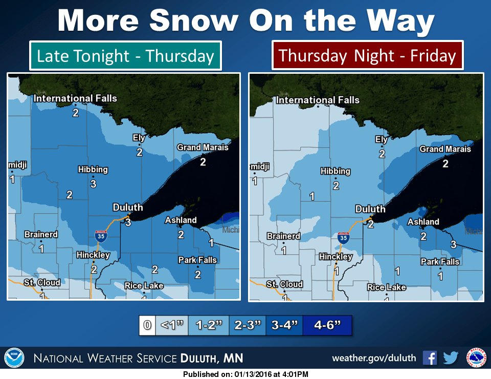
Snow in northern Minnesota
The steadiest snow blankets the northern half of Minnesota Thursday. NOAA's 4 km resolution NAM model lays down a stripe of moisture from the Red River Valley toward lake Superior. The Twin Cities rides the southern edge of this one.

A general blanket of 1 to 3 inches falls across the northern half of Minnesota. A heavier 2 to 5 inch stripe is centered on Grand Forks and Bemidji.

Many Iron Range and the North Shore communities pick up a combined 2 to 4 inches Thursday and Friday.
Going Arctic
You'll feel this cold front blasting through Friday night. This should be winter's best shot. Watch the cold sub-zero purple haze push south by early Sunday. Unnatural colors on the maps generally mean weather trouble.

Winter's bottom
This should be it, barring an unexpectedly barbaric Arctic shot in February. The latest read on the duration and magnitude of cold in the metro is for about 59 consecutive sub-zero hours according to ECMWF guidance. I'm still not buying the Euro's notion of -19 in the urban heat island at MSP, but -20 is looking likely Sunday and Monday morning in the outer metro 'burbs like Lakeville and Blaine.

Late January warming trend?
We often get a milder spell, or even a thaw after Arctic outbreaks. The longer-range guidance suggests above average temperatures again over Minnesota and the Great Lakes as we close out January.

Temperatures in the 30s and hints of snow pepper NOAA's GFS 16-day outlook.

The long-range view into February via daily runs of NOAA's CFS v2 model suggests a return to warmer than average temperatures across North America.

Rare January Atlantic Tropical Storm
Hurricane season begins June 1 in the Atlantic. Apparently Tropical Storm Alex didn't get the memo.
As our oceans warm, the notion of "hurricane seasons" are increasingly challenged.
Capital Weather Gang's Jason Samenow has more on the highly unusual January tropical systems in the Atlantic and Pacific.
For the first time since 1978, a named tropical weather system has formed in the Atlantic Ocean. At 4 p.m. today, the National Hurricane Center announced Subtropical Storm Alex had developed over the eastern Atlantic Ocean.
A subtropical storm is one that exhibits a combination of tropical and non-tropical characteristics.
Positioned 785 miles south-southwest of the Azores, Alex has maximum sustained winds of 50 mph. It is forecast to maintain this strength over the next couple of days as it zips northward and transitions into more of a non-tropical (or extratropical) storm. When it reaches the Azores Friday, it may unload 3 to 5 inches of rain, with some isolated totals to 7 inches.
On average, the first named storm in the Atlantic does not occur until July 9.
Capital Weather Gang contributor Phil Klotzbach notes the three other January tropical cyclones occurred in 1938, 1951 and 1978. He also says two other systems developed in December and survived into January: Alice in 1954-1955 and Zeta in 2005-2006.
Meanwhile, in the central Pacific, the Central Pacific Hurricane Center is issuing advisories for Hurricane Pali, which has maximum sustained winds of 80 mph. The storm located just 4 degrees in latitude north of the equator, is the third strongest storm to occur so far south on record in the northwest Pacific basin and the strongest storm to occur so close to the equator in the western hemisphere.
On Monday, Pali became the earliest hurricane to form in the central Pacific on record.