Southern Minn. on track for snow, tough morning commute ahead
Go Deeper.
Create an account or log in to save stories.
Like this?
Thanks for liking this story! We have added it to a list of your favorite stories.


Snowstorms are like the snowflakes they carry. Usually, no two are alike.
Our latest low pressure system takes the southern route. The lack of cold air with this system means a wetter snow. And a sharp northern edge makes for a quick cutoff from a couple of slushy inches, to little or nothing in the northwest metro.
A fresh coating of snow will blanket southern Minnesota into Wednesday morning. The Twin Cities rides the razor sharp northern edge of snowfall with this system. Wednesday morning's commute will bring snow and wet to slick roads for the Twin Cities. In southern Minnesota, heavier snow will make for difficult traveling conditions.
Turn Up Your Support
MPR News helps you turn down the noise and build shared understanding. Turn up your support for this public resource and keep trusted journalism accessible to all.
Winter storm warnings are out along the I-90 corridor in southern Minnesota counties.
Winter weather advisories sneak into southern metro counties.
Latest Twin Cities radar loop

In the storm's central snowfall core, there's potential for as much as a foot of heavy wet snow near the Iowa border with this system.
Thaw tracker
Tuesday was the eighth consecutive day above the thawing point in the Twin Cities. That makes for one of the longer January thaws on record. The string of four consecutive days and nights above freezing is a new record for the Twin Cities. In fact, St. Cloud has never recorded consecutive January days with low temperatures above freezing until this week. That's the kind of record that gets climate gurus talking.
Widespread January warmth
January temps in the 60s in Illinois and 70s in Indiana?
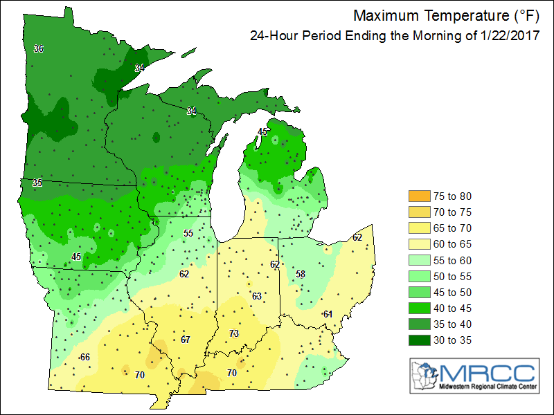
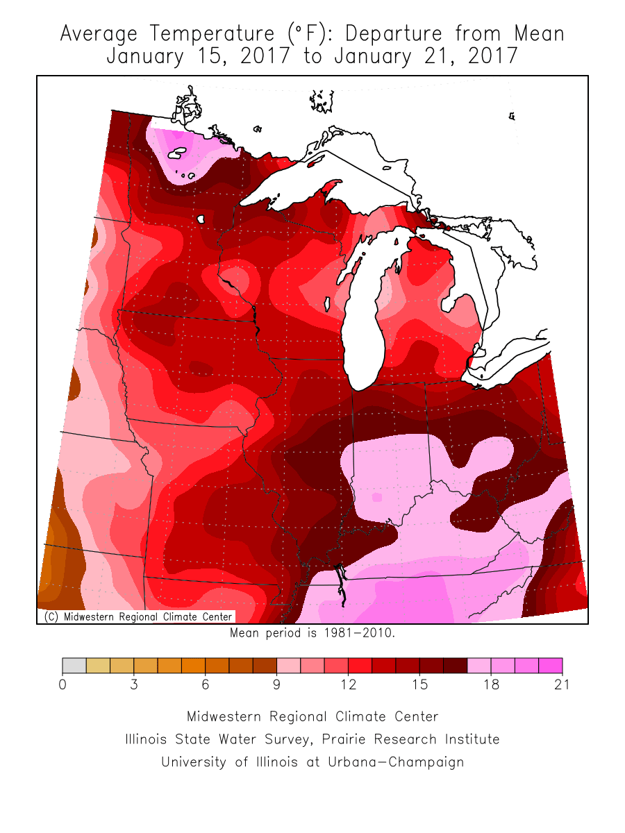
It felt more like March across the Midwest during the past week. Temps ran as much as 20 degrees warmer than average across northern Minnesota.
Here's more on the record January warmth from the Midwest Regional Climate Center.
Temperatures 10°F or more above-normal were widespread across the Midwest in an unusually warm week (Figure 4). Parts of southern Illinois, Indiana, Ohio and Kentucky were 15-18°F above normal. Most of Missouri, Iowa, Wisconsin and Minnesota were 12-15°F above normal. As a result, many daily high maximum and high minimum temperature records were broken. Over 50 high maximum temperature records were broken on January 20 (Figure 5) and January 21 (Figure 6), where temperatures in the 60’s were common across southern parts of the region. However, minimum temperatures had many more records broken. Over 180 high minimum temperature records were broken through the morning of January 20 (Figure 7). Only a few areas in the Upper Midwest had minimum temperatures below freezing through the morning of January 21, and more than 200 high minimum temperatures were recorded, with at least ten records in each Midwest state (Figure 8).
Back to winter reality?
We'll dip below freezing later this week but, temperatures will remain milder than average overall into early next week. There are signs of a couple frigid semi-Arctic jabs punching south again as February approaches.
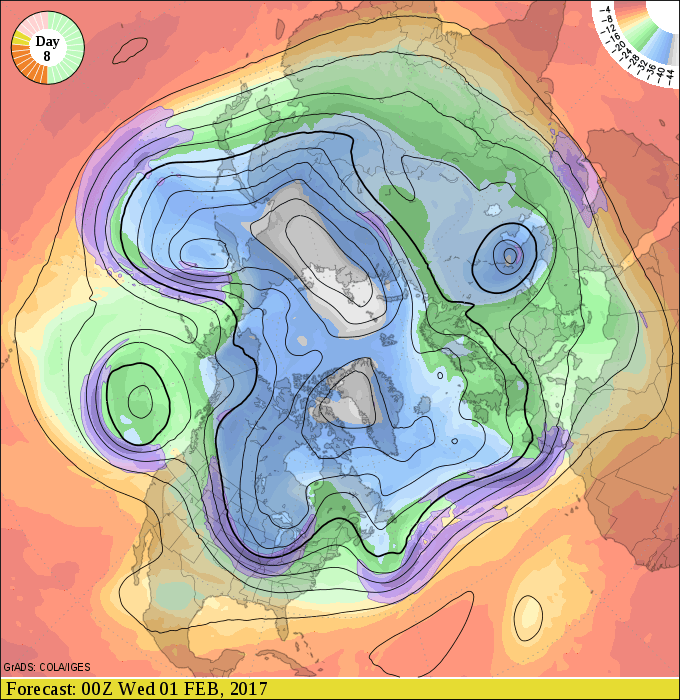
NOAA's GFS 16-day temp outlook favors colder air. Nothing super bitter, but lows may flirt with the zero mark in early February.
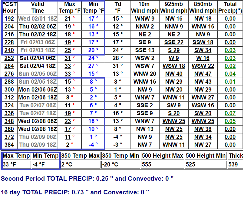
The season formerly known as winter is not over just yet.