
Summery highs in the 80s for most of Minn., western Wis. this weekend
Best weekend rain chances to the north and east
Go Deeper.
Create an account or log in to save stories.
Like this?
Thanks for liking this story! We have added it to a list of your favorite stories.


When we had those highs in the 70s earlier this week, I heard someone in line at the grocery store say “I hope summer isn’t over!”
No, it isn’t over. Summer has made a comeback.
Temperature trends
Most of Minnesota and western Wisconsin will see highs in the 80s Friday afternoon, with some upper-70s possible in a few spots along the North Shore of Lake Superior.
Turn Up Your Support
MPR News helps you turn down the noise and build shared understanding. Turn up your support for this public resource and keep trusted journalism accessible to all.
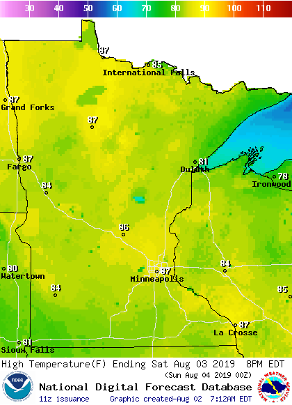
Saturday highs will be well into the 80s in many areas:
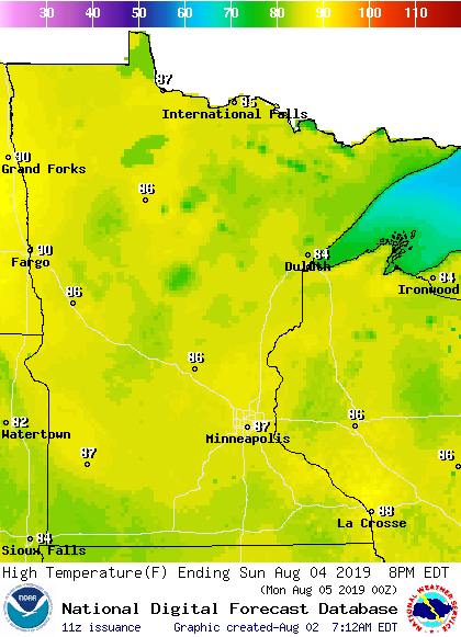
Similar highs are on tap for Sunday:
Looking into next week, Twin Cities metro area highs are projected to reach the mid-80s Monday and lower-80s on Tuesday, followed by around 80 degrees Wednesday and Thursday.
Rain and thunder chances
Periods of rain with some embedded thunderstorms will continue this Friday morning in portions of western Minnesota. Forecast models show that activity shrinking by early this afternoon.
Some scattered showers and thunderstorms will be possible Friday afternoon and evening in roughly the northern half of Minnesota and far northern Wisconsin.
As always, updated weather information can be heard on the Minnesota Public Radio Network, and you’ll also see updated weather info on the MPR News live weather blog.
The northern half of Minnesota, plus northern Wisconsin, will have a chance of scattered afternoon and evening showers and thunderstorms this weekend. There could be an isolated shower/thunderstorm in west-central Wisconsin on Saturday.
The Twin Cities metro area could see an isolated shower or thunderstorm late Saturday afternoon or Saturday evening.
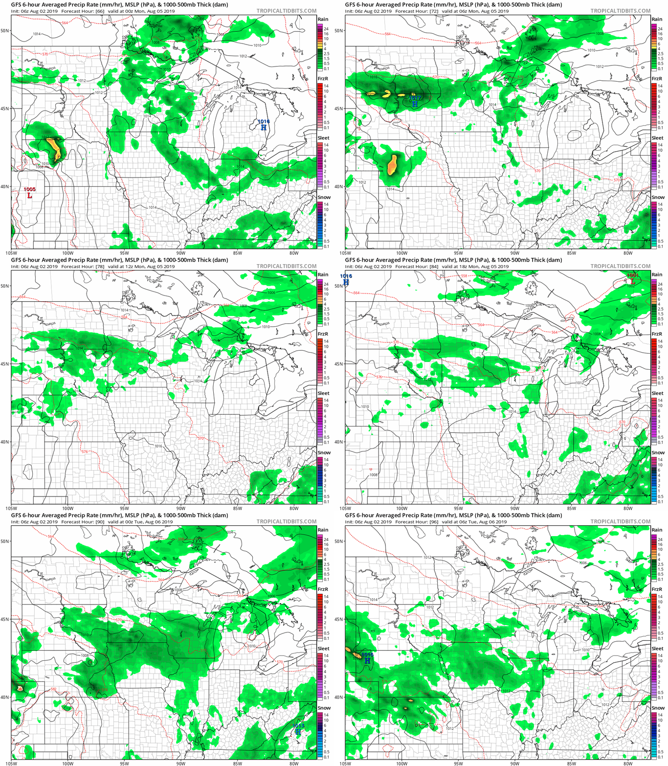
There’s a good chance that much of Minnesota and western Wisconsin will see some rain at times on Monday. The National Oceanic and Atmospheric Administration’s Global Forecast System model shows the potential rain pattern Sunday evening through Monday evening:
Climate Cast update
The Climate Reality Project event opens in the Twin Cities Friday and runs through Sunday. They expect 1,200 people to attend this event this weekend.
MPR News meteorologist Paul Huttner will be moderating a panel discussion on cities and climate change between St. Paul Mayor Melvin Carter and Minneapolis Mayor Jacob Frey at the event Sunday.

Paul’s special Friday Climate Cast interview with former Vice President Al Gore will air around 5:44 p.m. Friday afternoon on All Things Considered.
Tune in Friday for Climate Cast and monitor MPR Weather on Twitter for updates.
Tropical storm Erick
What had been Hurricane Erick is now Tropical Storm Erick as it passes well to the south of Hawaii:
Updates on Erick are available from the NWS Central Pacific Hurricane Center, and the NWS Honolulu, Hawaii office.
Programming note
You can hear my live weather updates on Minnesota Public Radio at 7:49 a.m. Thursdays and Fridays, and at 7:35 a.m., 9:35 a.m. and 4:35 p.m. each Saturday and Sunday.

