
How high will it go? Tracking the December thaw
Highs in the 40s look likely this weekend

Go Deeper.
Create an account or log in to save stories.
Like this?
Thanks for liking this story! We have added it to a list of your favorite stories.


It’s been a cold December overall so far across Minnesota.
Most of Minnesota recorded milder than average temps first 8 days of December. Then Arctic air settled in on December 9. Nine of the past ten days have brought temperatures significantly colder than average. All 5 sub-zero lows in the Twin Cities have occurred starting on December 9.
The Twin Cities are running 2.9 degrees below average so far this month. Duluth and many northern Minnesota locations are running more than 5 degrees colder than average.
Warm front arrives
Turn Up Your Support
MPR News helps you turn down the noise and build shared understanding. Turn up your support for this public resource and keep trusted journalism accessible to all.
The average high and low in the Twin Cities today are 26 and 11 degrees. Temperatures hovered around 13 degrees at midnight and pushed to near 30 degrees today. So today will go in the books as just the 2nd warmer than average day in the past 10 days.
Temperatures crack the thawing point Friday across much of southern Minnesota. It appears most of southern Minnesota will string together at least 5 days of highs in the 30s between Friday and Christmas Day.
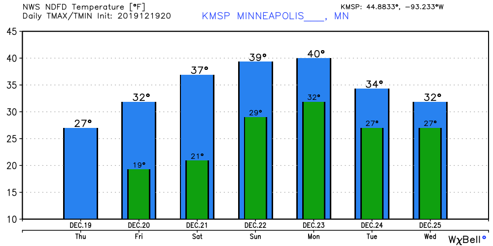
Peak warmth Monday
Sunday and Monday will likely be the warmest days of this December thaw. Highs near 40 degrees will melt some serious snow across southern Minnesota.
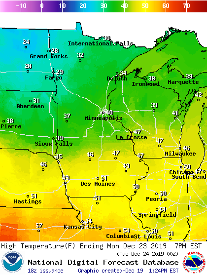
Gauging peak warmth
How high will the mercury go during this thaw? Thta’s a question that’s dependant on a few key factors.
Air mass potential: How warm is the inbound air mass? As you can see on the map below this airmass is plenty warm enough to drive temperature into the upper 40s to near 50 degrees into central and northern Iowa.
Snow cover: Snow cover is fading fast in Iowa. Snow cover in southern Minnesota is only a few inches. That will likely be mostly gone by Sunday afternoon. So highs well into the 40s are likely there. The Twin Cities has 7 inches of snow cover as of today. That will limit our warm up some, but we may see bare spots opening up on south-facing slopes by Sunday.
Fog? Snowmelt may trigger some early morning fog in the next few days. But low-level winds look breezy enough o mix out most of the fog this weekend. That should assure plenty of sunshine to help boost afternoon temperatures.
Extreme event bias: Forecast models often underestimate temperatures during events that skew far away from averages. My assessment is this is one of those times. I’m inclined to say temperatures will likely reach or exceed 40 degrees in the Twin Cities Saturday through Monday. The NOAA GFS extended range guidance below looks credible to me for the Twin Cities. That would push temperatures as high as 45 degrees during this December thaw event.

Stay tuned.

