Thaw arrives; spotty rain and snow showers

Temperatures 10 degrees warmer than average for the next week

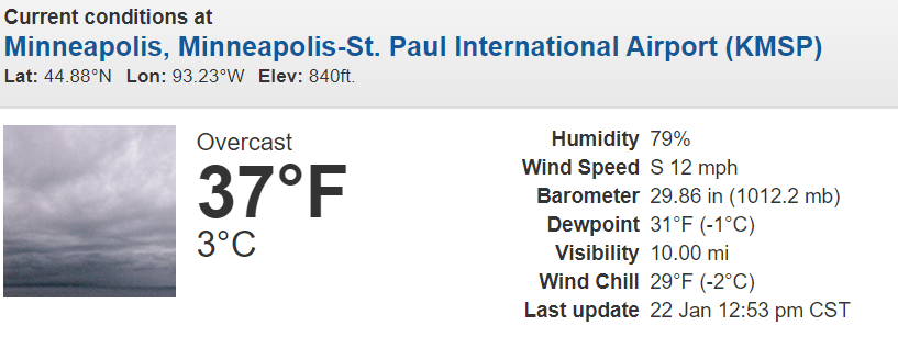
Early afternoon weather conditions at Twin Cities International Airport
NOAA

The thaw is here, and this one looks like it will stick around a while. But it comes with a winter weather advisory.

Winter weather advisory
Twin Cities National Weather Service

Including the Minnesota cities of Red Wing, Owatonna, Blue Earth and Albert Lea and the Wisconsin cities of River Falls, Prescott, Menomonie, Durand, Chippewa Falls, and Eau Claire.

1146 AM CST Wed Jan 22 2020 ...WINTER WEATHER ADVISORY NOW IN EFFECT UNTIL 5 PM CST THIS AFTERNOON...

* WHAT...Snow accumulations of 1 to 2 inches.

* WHERE...Portions of west central Wisconsin and south central and southeast Minnesota.

* WHEN...Until 5 PM CST this afternoon.

* IMPACTS...Plan on slippery road conditions. The hazardous conditions could impact the evening commute.

Thawing out

Minnesota is riding the northern edge of an above-freezing Pacific air mass as we move into late January.

Temperatures Wednesday afternoon
Oklahoma Mesonet

Staying power

There are some remarkable elements of this January thaw. First, this looks like a long-duration event. Highs will be at or above freezing into next week in the Twin Cities and most of southern Minnesota.

And take a look at the overnight lows on the chart below. We’ll barely dip below freezing over the next week at night. So overnight minimum temperatures will be about 20 degrees warmer than the average low of 8 degrees by next week.

Create a More Connected Minnesota

MPR News is your trusted resource for the news you need. With your support, MPR News brings accessible, courageous journalism and authentic conversation to everyone - free of paywalls and barriers. Your gift makes a difference.

Temperature forecast for Twin Cities
National Oceanic and Atmospheric Administration, via Weather Bell

Warm January in the bag?

The medium-range upper-air maps continue to support milder than average temperatures for the rest of January. That means we’ll finish the month well above average.

Colder by early February?

There are signs more subzero temperatures may push south as we move in the first week of February. The upper-air forecast suggests a deep trough of low-pressure diving south from Canada.

Upper air forecast map for 6 pm February 5
NOAA

That could bring another shot of subzero air during the first week of next month.

Stay tuned.