
Gauging the warmup: A legitimate shot at 60 Sunday
The warmest air mass of 2020 so far arrives this weekend
Go Deeper.
Create an account or log in to save stories.
Like this?
Thanks for liking this story! We have added it to a list of your favorite stories.


The weather maps continue to run red as March unfolds.
Temperatures are already running 10 degrees warmer than average for the first days of March in the Twin Cities. Highs in the 40s look likely the rest of this week for much of southern Minnesota. Minnesota rides the northern edge of a widespread springlike air mass this week. It feels like spring across most of the U.S. from Iowa southward.

Weekend warm surge
This weekend brings an even milder surge of Pacific air. The upper air forecast maps for Saturday feature a well-amplified ridge of high pressure across the central U.S.

Highs this week hover in the low 40s in the Twin Cities. Then this weekend, southwest winds blow in the warmest air so far in 2020. Many forecast models crank out highs near 60 degrees in the Twin Cities Sunday afternoon.
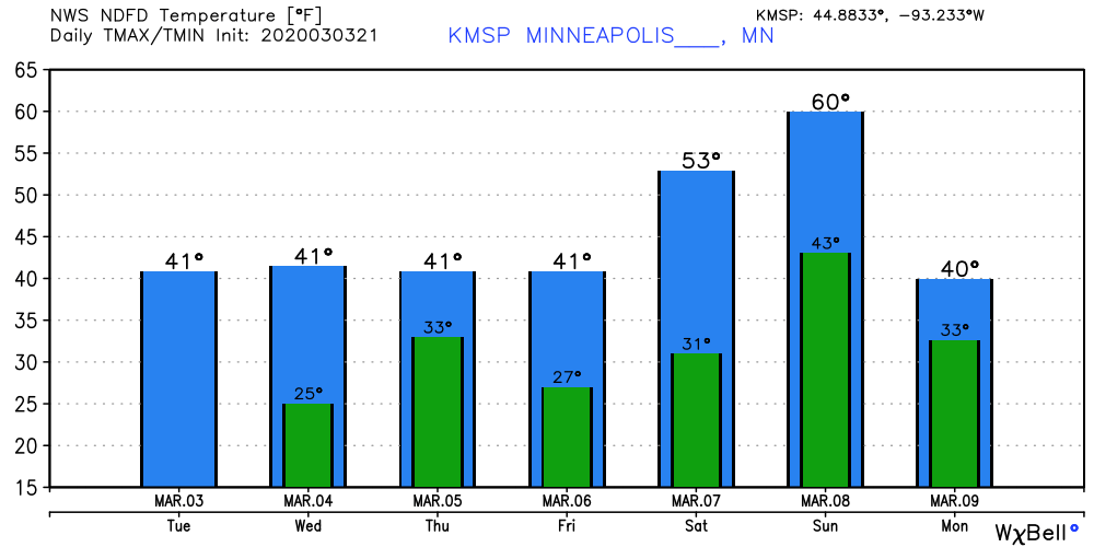
Highs around 60 could be conservative if we lose most of the snow cover across southern Minnesota by Sunday.
I still think we’re not done with snow yet this spring. NOAA’s GFS model today hiccuped about the possibility of snow for Minnesota around St. Patrick's Day.
Stay tuned.
Turn Up Your Support
MPR News helps you turn down the noise and build shared understanding. Turn up your support for this public resource and keep trusted journalism accessible to all.

