
March reality check: The other shoe arrives
Colder pattern ahead as we move deeper into March
Go Deeper.
Create an account or log in to save stories.
Like this?
Thanks for liking this story! We have added it to a list of your favorite stories.


Most of Minnesota went to bed in late April and woke up in March.
Sunday’s high of 61 degrees at MSP Airport was the warmest day since October 20. It is also the average high for April 22.
Our March reality check kicked into high gear today with chilly northerly breezes. A more typical March air mass is sagging south from Canada early this week. Blue is the dominant color across the Upper Midwest once again. Springlike weather has been shoved southward.

Mid-week warm-up
Turn Up Your Support
MPR News helps you turn down the noise and build shared understanding. Turn up your support for this public resource and keep trusted journalism accessible to all.
It will be brief, but temperatures will rebound again as we move into the middle of the week. Highs push toward 50 again in the Twin Cities by Wednesday. Temps fall again late this week under cool northwest flow.
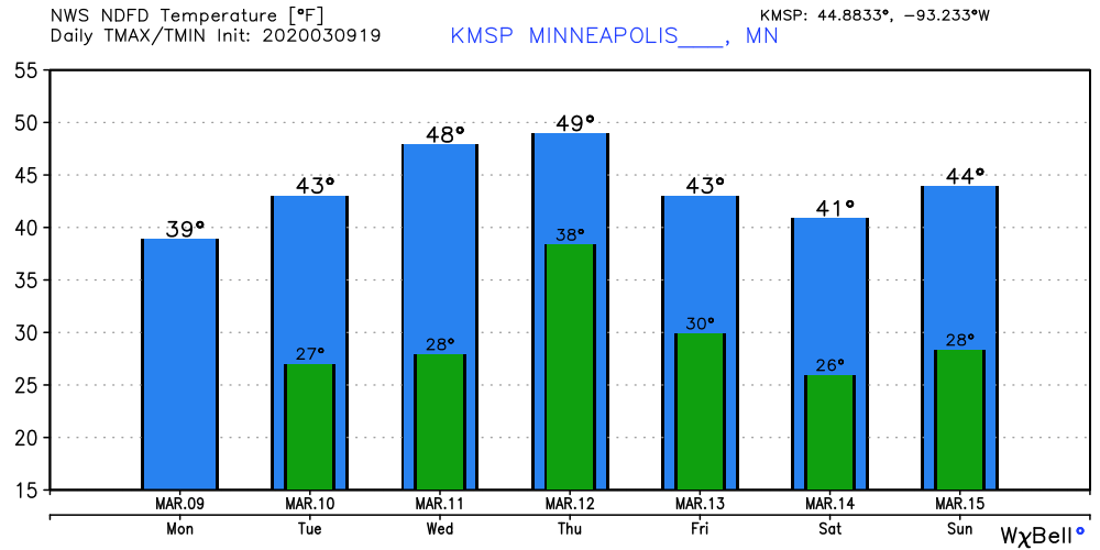
A couple of minor rain and snow chances sweep through Tuesday night, and again Thursday. Northern Minnesota could see some accumulating snow Thursday.
Rising rivers
The rapid snowmelt over the weekend has rivers on the rise. Flooding is occurring at a few sites. You can check river levels and forecasts here.
Ice jams can occur as ice breaks up and rushes downstream. Check out this video near Mankato.
Keep an eye out for rapidly fluctuating river levels this week.

