
Brighter weekend ahead; a shot at 70 by Tuesday?
Our wintry Friday interlude gives way to the warmest air mass of 2020 so far next week

Go Deeper.
Create an account or log in to save stories.
Like this?
Thanks for liking this story! We have added it to a list of your favorite stories.


Our wintry Friday interlude with ice, snow and even some graupel gives way to sunnier skies this weekend.
We typically get at least one more shot of wintry weather in early April. At least I don’t see another April blizzard on the horizon this year.
It’s the little things.
Nicer weekend
Our weather improves this weekend. Sunnier bright blue skies return. Saturday runs cool with highs in the 40s. Sunday brings highs back into the 50s across much of Minnesota. Cooler by the lake and in the northwest corner.
Turn Up Your Support
MPR News helps you turn down the noise and build shared understanding. Turn up your support for this public resource and keep trusted journalism accessible to all.
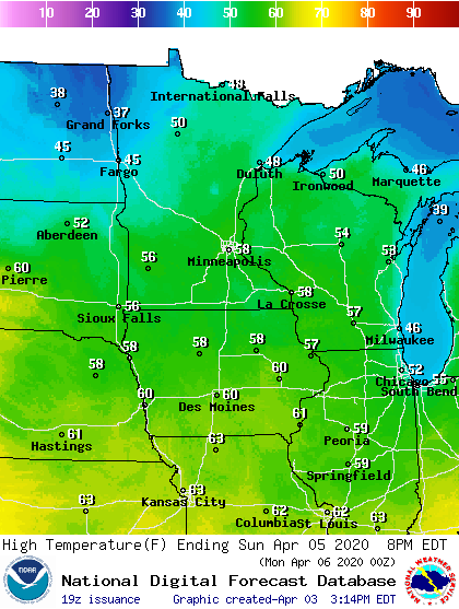
This will be a great weekend for some socially distant outdoor exercise. There’s a sentence I never saw myself writing.
Warmest air mass so far next week
Next week brings the warmest air mass so far in 2020. Highs reach the mid-60s on a springy Monday in southern Minnesota. By Tuesday afternoon, we make a run at the year’s first 70-degree temperature for some towns in southern Minnesota.
April thundershowers?
We’ll see a few April showers Sunday night and Monday night across Minnesota. Tuesday could bring more widespread showers in the northern half of Minnesota.
Looking at the maps I could see a few thunderstorms pop up Tuesday afternoon in southern Minnesota. Model forecast CAPE (Convectively Available Potential Energy) levels suggest thunderstorms are possible from the Twin Cities southward Tuesday afternoon.

Could we see our first severe risk areas and severe weather watch in 2020 for parts of Minnesota next week?
Stay tuned.

