Temperature focus: Freeze warnings Thursday night; warming trend next week
What are the average last spring freeze dates in Minnesota?
Go Deeper.
Create an account or log in to save stories.
Like this?
Thanks for liking this story! We have added it to a list of your favorite stories.


Cover up your super petunias, Minnesota.
The combination of clear skies, light winds and dew points in the single digits and teens are the perfect combination for freezing temperatures. If fact, the air over Minnesota Thursday is drier than the Sonoran Desert in Arizona where dew points are in the upper 20s Thursday.
Freeze warning
The freeze warning Friday morning covers all of southern Minnesota and much of central Wisconsin and eastern South Dakota.
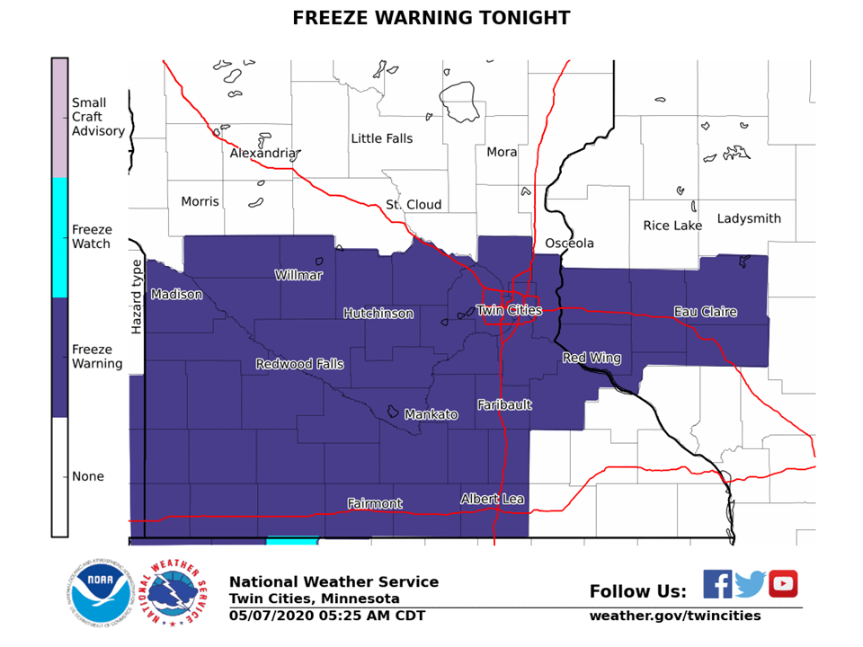
Including the cities of Willmar, Litchfield, Monticello, Minneapolis, Blaine, St Paul, Stillwater, Olivia, Hutchinson, Gaylord, Chanhassen, Chaska, Victoria, Shakopee, Hastings, New Ulm, St Peter, Le Sueur, Faribault, Red Wing, St James, Mankato, Waseca, Owatonna, Fairmont, Blue Earth, Albert Lea, Hudson, River Falls, Menomonie, Durand, Chippewa Falls, and Eau Claire
236 PM CDT Thu May 7 2020 ...FREEZE WARNING REMAINS IN EFFECT FROM 3 AM TO 9 AM CDT FRIDAY... ...FREEZE WATCH REMAINS IN EFFECT FROM LATE FRIDAY NIGHT THROUGH SATURDAY MORNING...
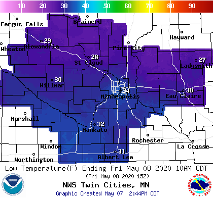
* WHAT...For the Freeze Warning, sub-freezing temperatures as low as 28 expected. For the Freeze Watch, sub-freezing temperatures as low as 28 possible. The core of the Twin Cities metro will likely remain in the mid 30s both nights.
* WHERE...Portions of west central Wisconsin and central, east central, south central and southeast Minnesota.
* WHEN...For the Freeze Warning, from 3 AM to 9 AM CDT Friday. For the Freeze Watch, from late Friday night through Saturday morning.
* IMPACTS...Frost and freeze conditions will kill crops, other sensitive vegetation and possibly damage unprotected outdoor plumbing.
Why no freeze warning across northern Minnesota? Freeze warnings are usually only issued in areas that during the typical growing season or where things have already greened up. Here’s more from the Twin Cities National Weather Service office.
Turn Up Your Support
MPR News helps you turn down the noise and build shared understanding. Turn up your support for this public resource and keep trusted journalism accessible to all.
A freeze warning remains in place for most of the area, where green-up is well underway (no headline is in place across the north where the growing season isn`t as established)
Low Friday morning will dip well below freezing across much of Minnesota. The inner Twin Cities metro core (494/694 loop) may see lows in the low to mid-30s.
A freeze watch continues into Saturday morning.
Late frost for MSP?
The average date for the last 32-degree temperature at the Minneapolis-St. Paul International Airport is April 25. But freezing temperatures are typical for most of Minnesota in May.
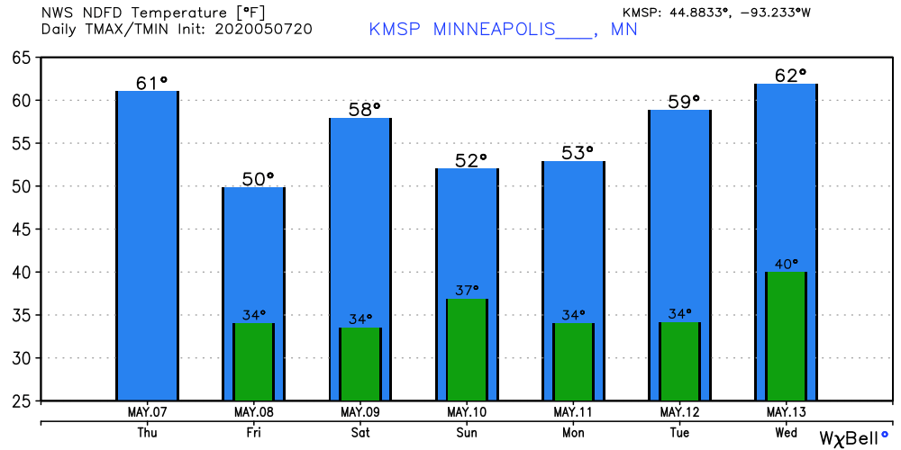
Warming trend next week
Temperatures remain chilly through the weekend. A warming trend kicks in toward the middle of next week. Highs return to the 60s once again by next Wednesday.