Hot and stormy: Head advisory and severe risk Wednesday includes Twin Cities
Heat index values near 100 degrees Wednesday; storms likely
Where’s the nearest beach?
A heat advisory kicks in Wednesday at noon for much of southern Minnesota including the Twin Cities area. Heat index values will reach 100 degrees across parts of southern Minnesota Wednesday afternoon.

Including the cities of Monticello, Hutchinson, Gaylord, St Peter, Le Sueur, Faribault, Red Wing, Mankato, Waseca, Owatonna, Blue Earth, Albert Lea, Hudson, River Falls, Menomonie, Durand, Chippewa Falls, and Eau Claire
305 PM CDT Tue Jul 7 2020 ...HEAT ADVISORY IN EFFECT FROM NOON TO 7 PM CDT WEDNESDAY...
* WHAT...Heat index values around 100 degrees expected.
* WHERE...Portions of west central Wisconsin and central, south central and southeast Minnesota.
* WHEN...From noon to 7 PM CDT Wednesday.
* IMPACTS...Hot temperatures and high humidity may cause heat illnesses to occur.
The Twin Cities has recorded eight days of 90-degree heat so far this year. Wednesday looks like day 9. That approaches our annual average of 11 days at or above 90 degrees. And we’re not even halfway through meteorological summer yet. At this rate, we’re on pace for 18 to 20 days of 90-degree heat this year. The record is 44 days set back in the steamy summer of 1988.
Steamy July
Temperatures are running more than 7 degrees warmer than average so far for the month of July in the Twin Cities. The medium-range forecast maps continue to favor warmer than average temperatures overall for the remainder of July.
Create a More Connected Minnesota
MPR News is your trusted resource for the news you need. With your support, MPR News brings accessible, courageous journalism and authentic conversation to everyone - free of paywalls and barriers. Your gift makes a difference.

With June coming in at 4 degrees warmer than average in the Twin Cities, it appears highly likely this will be a hotter than average summer overall in Minnesota. I’m not surprised in this year of 2020.
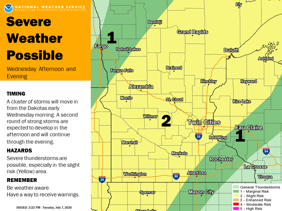
Wednesday severe risk
Severe weather still looks likely overnight in northwest Minnesota and early Wednesday across northern Minnesota. The most favored time for storms in eastern Minnesota and the Twin Cities is late Wednesday afternoon into Wednesday evening.

Forecast models differ on coverage and timing of storms Wednesday. NOAA’s NAM 3 km resolution model continues to paint two separate waves of severe storms crossing Minnesota overnight into Wednesday evening. Here’s the run from 10 pm Tuesday to 10 pm Wednesday.

Expect severe weather watches and warnings across Minnesota Wednesday.