
MPR weather alert: Widespread damaging wind event likely across Minn. Friday night
Derecho possible with blowdown-type wind damage; gust to 80-plus mph possible

Go Deeper.
Create an account or log in to save stories.
Like this?
Thanks for liking this story! We have added it to a list of your favorite stories.


It’s not often I type language this urgent and graphic in Updraft posts. But everyone in northern and central Minnesota needs to be aware of a serious damaging wind threat overnight into the wee hours of Saturday morning.
Update 6 pm: NOAA has issued a rare PDS (Particularly Dangers Situation) Severe Thunderstorm Watch until 1 am for much of central Minnesota. Includes far northwest Twin Cities suburbs.
Severe Thunderstorm Watch Number 380 NWS Storm Prediction Center Norman OK
535 PM CDT Fri Jul 17 2020 The NWS Storm Prediction Center has issued a
* Severe Thunderstorm Watch for portions of Northern and central Minnesota Southeast North Dakota Northern South Dakota
* Effective this Friday afternoon and Saturday morning from 535 PM until 100 AM CDT. ...THIS IS A PARTICULARLY DANGEROUS SITUATION...
* Primary threats include... Widespread damaging winds expected with scattered significant gusts to 90 mph likely Scattered large hail and isolated very large hail events to 2.5 inches in diameter possible A couple tornadoes possible
SUMMARY...An intense linear-type complex of storms is expected to evolve into a derecho this evening and produce widespread/significant damaging winds as it accelerates east-southeastward across the region. Isolated large hail is also possible, and a tornado risk cannot be ruled out, particularly near the warm front.
Here’s my latest read on the severe weather situation Friday night after scanning the latest forecast model runs. Changes in storm timing and coverage maybe hour to hour Friday night, so this is a heads up. You’ll need to closely follow NWS, NOAA weather radio, and other sources to keep updated overnight.
You can hear warnings as they are issued on MPR News stations across Minnesota.
Turn Up Your Support
MPR News helps you turn down the noise and build shared understanding. Turn up your support for this public resource and keep trusted journalism accessible to all.

Severe risk zone
The elevated severe wind damage risk zone overnight favors northern and central Minnesota. Here’s the risk area for the Red River Valley and northwest Minnesota from the Grand Forks NWS office.

Here’s the risk zone from the Duluth NWS office.

The Twin Cities lies on the southern edge of the threat zone. Many forecast models keep storms mostly north of the Twin Cities. A few suggest the Twin Cities could get clipped by storms around 2 to 3 a.m.

Storm timing
Forecast models vary on precise storm timing so this may change. Here is NOAA’s HRRR model. It depicts a bow echo/derecho racing at 40-50 mph from the Red River Valley across northern Minnesota overnight. This loop runs between 7 p.m. Friday and 7 a.m. Saturday.
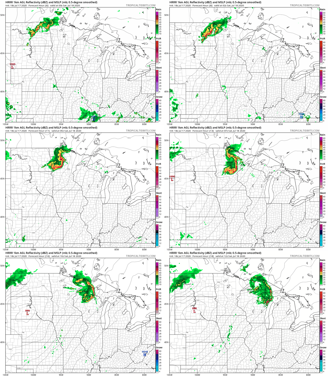
Here is my read on the highest risk timing windows for damaging winds in various parts of Minnesota overnight. I can’t list every location, so please infer based on your location. Again, the timing could change a bit so stay updated.
Red River Valley: 6 to 9 p.m.
Bemidji, Detroit Lakes, Fergus Falls, Alexandria: 7 p.m. to 9 p.m.
Walker (Leech Lake), Brainerd lakes, Little Falls, St. Cloud: 8 p.m. to midnight.
BWCA, Iron Range, Lake Mille Lacs: 10 p.m. to midnight
Duluth, Hinckley, Interstate-35 corridor: 11 p.m. to 1 a.m.
Damage threat
There is an elevated risk Friday night for a widespread damaging wind event. Damaging bow echoes and a long track damaging wind event called a derecho are possible. NOAA’s Storm Prediction Center has highlighted the potential for “hurricane-force winds.”
Here are the likely impacts on the ground.
Widespread wind gusts from 60 to 80+ mph.
Widespread tree damage including uprooting and snapped tree trunks.
Possible blowdown-type tree damage across large areas.
Widespread power outages with power lines down.
Safety
Here are some special considerations for safety Friday night with this system.
Storms will occur overnight. Have a NOAA weather radio or another way to wake you when warnings are issued.
Campers in tents or camp trailers are NOT safe. Everyone needs to be indoors in a sturdy structure overnight.
If you know somebody that’s camping Friday night and can reach them now, please let them know tents are not safe Friday night. Get them indoors.

Resources
Here are some links to severe weather resources.
Stay safe out there overnight!

