
It's a record: Warmest Election Day in the Twin Cities and much of Minnesota
Highs pushed into the 70s in much of Minnesota on Election Day 2020. Temps hit 80 in southwest Minnesota.

Go Deeper.
Create an account or log in to save stories.
Like this?
Thanks for liking this story! We have added it to a list of your favorite stories.


It’s official.
The Twin Cities set a record Tuesday for the warmest Election Day on record. Temperatures soared into the 70s this afternoon across much of Minnesota. Temperatures pushed the 80-degree mark in southwest Minnesota.

Temperatures are still climbing as of this post. During the 1 pm hour, the temperature hit 72 degrees at MSP Airport. That broke the previous record of 71 degrees set on Election Day 2008.
Election Day 2008 was on Nov. 4. The daily record high in the Twin Cities for Nov. 3 is 74 degrees also set in 2008.
The temperature soared to 81 degrees in Madison in southwest Minnesota Tuesday afternoon.
More records this week?
Daily record highs in the Twin Cities run in the low to mid-70s this week. High temperatures may challenge daily records again Wednesday and on Friday and Saturday. The high-temperature forecast for Wednesday below looks to be a few degrees to conservative.
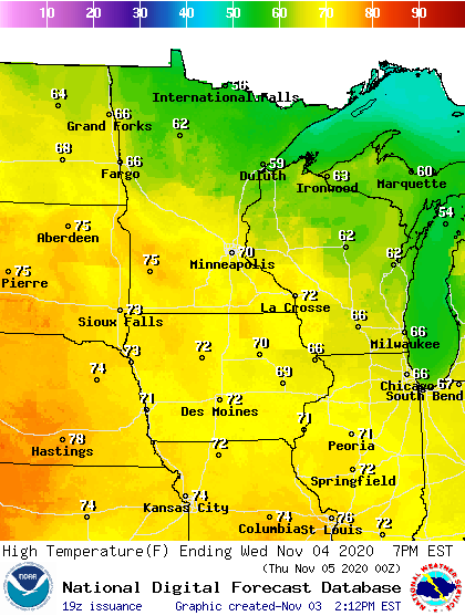
The unseasonably warm weather will last through Sunday. Much colder weather returns next week.
Turn Up Your Support
MPR News helps you turn down the noise and build shared understanding. Turn up your support for this public resource and keep trusted journalism accessible to all.

