Sunshine Saturday, light snow Sunday, a big thaw by Monday
Temperatures push the 40-degree mark by Monday afternoon
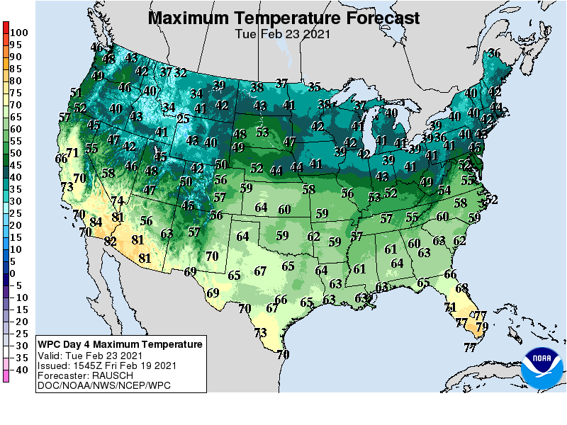
Get ready for a little bit of everything in the next few days Minnesota.
I posted earlier today about the air quality advisory this weekend. In addition to that news, we have a classic winter Saturday, and shot of light snow Sunday and a big thaw early next week.
Classic Saturday
Saturday brings light winds and sunshine to start the day. High clouds will drift eastward in the afternoon. Highs will reach the 20s across Minnesota for a classic winter Saturday. It will be a great day to get out and enjoy our snow cover.
Light snow Sunday
A weak low-pressure system brings light snow to Minnesota Sunday. NOAA’s NAM 3 km resolution model paints the most consistent snow across southeast Minnesota.
Most of Minnesota will see an inch or less Sunday. A swath of 1 to 3 inches looks likely for southeast Minnesota.
Big thaw next week
California breezes blow into Minnesota early next week. Highs could touch 50 degrees in western Minnesota Monday or Tuesday afternoon. Highs in the 40s favor areas form the Twin Cities westward. Highs in the 30s will be common in northeast Minnesota.
Temperatures look cooler later next week with highs mainly in the 20s. Right now I don’t see any big cold waves in sight. Some models hint at a possible rain/snow system toward the end of the first week in March.
Create a More Connected Minnesota
MPR News is your trusted resource for the news you need. With your support, MPR News brings accessible, courageous journalism and authentic conversation to everyone - free of paywalls and barriers. Your gift makes a difference.