Tracking snow system tonight into early Wednesday

Accumulating snow favors central Minnesota. Twin Cities dusting Wednesday morning?
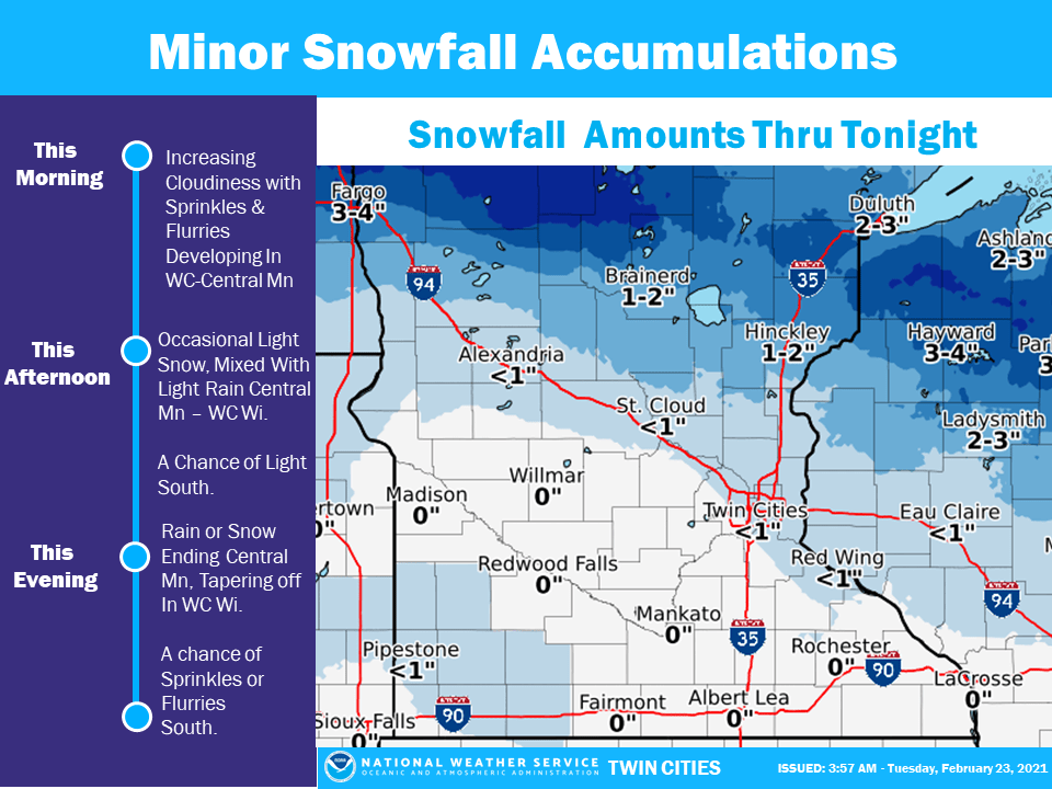
Snowfall projection
Snowfall projection
Twin Cities National Weather Service

We’re tracking a Clipper system packing some snow to a swath of central Minnesota into Wednesday morning.

The low-pressure system tracks across central Minnesota Tuesday night. Most of the snow will fall along and north of Interstate 94.

NOAA’s GFS model paints the snow zone across central Minnesota between 6 p.m. Tuesday and 6 a.m. Wednesday.

NOAA GFS model
NOAA GFS model from 6 pm Tuesday to 6 am Wednesday.
NOAA via tropical tidbits

Snowfall totals

Create a More Connected Minnesota

MPR News is your trusted resource for the news you need. With your support, MPR News brings accessible, courageous journalism and authentic conversation to everyone - free of paywalls and barriers. Your gift makes a difference.

As low-pressure systems go, this one is weak to moderate in strength. The heaviest snowfall potential favors the Red River Valley and west-central Minnesota towns like Ada, Park Rapids, and Detroit Lakes. That’s the zone that will likely see 1 to 3 inches, with a score of 3 to 6 inches possible.

Snowfall totals from the Grand Forks NWS office
Grand Forks NWS Office

The system will produce lighter snowfall totals across parts of east-central Minnesota. Look for a general 1 to 3-inch snowfall zone from near Brainerd through the Iron Range, Duluth and Hinckley.

Snowfall totals from the Duluth NWS office
Duluth National Weather Service

The Twin Cities could pick up a light snowy dusting Wednesday morning. Snowfall totals will be less than an inch in most areas.

Snowfall projection
Snowfall projection
Twin Cities National Weather Service

Keep an eye out for slick roads in the snow zone Tuesday night and Wednesday morning.