
Snowfall update: Heavier snow brushing southwest Twin Cities today
Ides of March system with heavier snow band just southwest of Twin Cities.

Go Deeper.
Create an account or log in to save stories.
Like this?
Thanks for liking this story! We have added it to a list of your favorite stories.


Here’s an afternoon update on our Ides of March snowfall today.
Mankato has already picked up 5 inches of snowfall as of 10:30 a.m.
A band of heavier snow has set up southwest of the Twin Cities and is nudging slowly northward.
Expect snowfall of varying intensity through the afternoon hours from the Twin Cities southward.
Turn Up Your Support
MPR News helps you turn down the noise and build shared understanding. Turn up your support for this public resource and keep trusted journalism accessible to all.
Winter storm warnings now include the far southwest Twin Cities.
Including the cities of Hutchinson, Chanhassen, Chaska, Victoria, Shakopee, and Faribault 1155 AM CDT Mon Mar 15 2021
...WINTER STORM WARNING REMAINS IN EFFECT UNTIL 7 PM CDT THIS EVENING...
* WHAT...Heavy snow expected. Total snow accumulations of 5 to 7 inches. Winds gusting as high as 35 mph.
* WHERE...McLeod, Carver, Scott and Rice Counties.
* WHEN...Until 7 PM CDT this evening. * IMPACTS...Travel could be very difficult. The hazardous conditions could impact the morning or evening commute.
Big snowfall gradient across Twin Cities
Heavier snowfall band Monday favor the southwest Twin Cities. There will be a big snowfall gradient across the Twin Cities from southwest to northeast today.
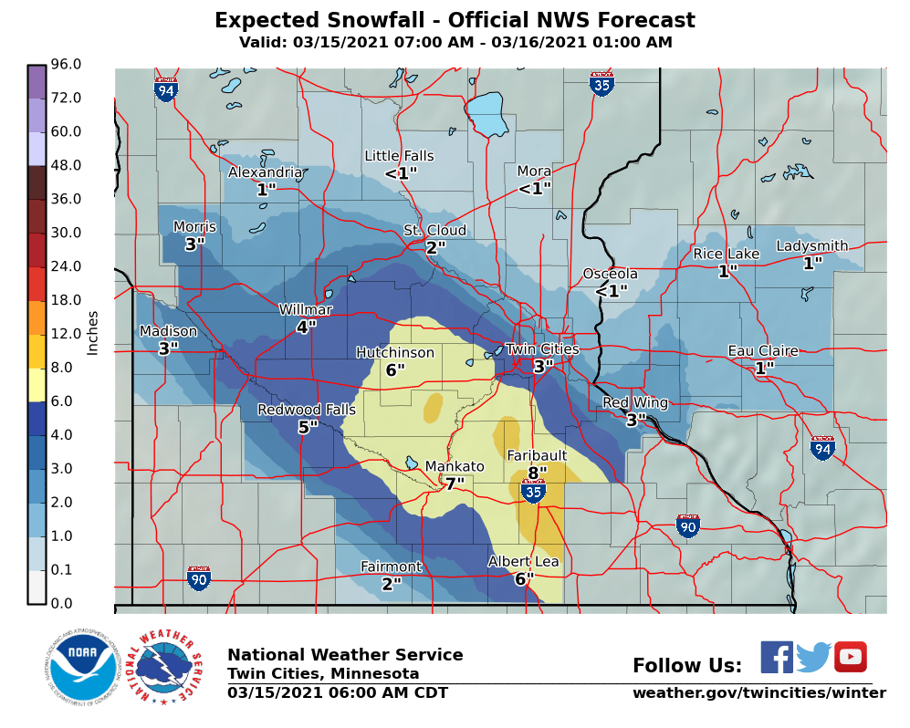
The National Oceanic and Atmospheric Administration’s GFS model lays out the heavy snow band across south-central and southeast Minnesota.

With temperatures at or below freezing, expect a mix of wet and slippery road conditions depending on the intensity of snowfall in various locations.

