Record for longest early season heat wave likely set Tuesday

Monday marks six straight days of 90-degree heat in MSP. The streak likely reaches nine days by Friday.

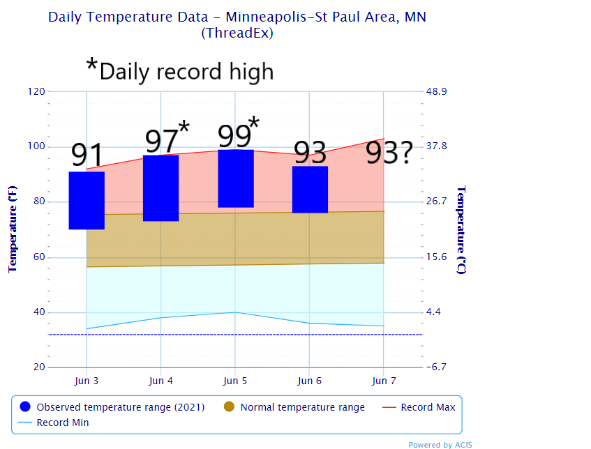
High temperatures at MSP Airport from Friday through Monday
NOAA

We’re sweating through what looks like the longest early-season heat wave for the Twin Cities and parts of Minnesota.

Monday marks the fifth straight day of 90-degree heat in the Twin Cities and much of western and southern Minnesota. You can see the individual daily highs above. We also set daily record highs Friday and Saturday in the Twin Cities and several other locations.

If we hit 90 as expected Tuesday, it will tie the record of six days as the longest streak of 90-degree days before June 15 in the Twin Cities. That has happened three times, lastly in 2018.

Early season 90-degree heat records
Early season 90-degree heat records for the Twin Cities.
Minnesota DNR Climate Working Group

Forecast: Hot all week

Temperatures will likely reach 90 to 95 degrees through Thursday or Friday in the Twin Cities and most of southern Minnesota.

Create a More Connected Minnesota

MPR News is your trusted resource for the news you need. With your support, MPR News brings accessible, courageous journalism and authentic conversation to everyone - free of paywalls and barriers. Your gift makes a difference.

weather graphic
Twin Cities forecast versus record highs through Friday
National Weather Service

That means that our streak of 90-degree days will likely reach eight or nine by Thursday and Friday.

So we’re living through what looks like the longest duration early-season 90-degree heat wave in Twin Cities history.

The heat advisory for the greater Twin Cities continues through Thursday at 8 p.m.

Stay cool, Minnesota.