
Scattered rain and storms fade overnight; much cooler and less humid this week
A pleasant air mass follows Tuesday's rain
Go Deeper.
Create an account or log in to save stories.
Like this?
Thanks for liking this story! We have added it to a list of your favorite stories.


Tuesday delivered welcome rains to many Minnesota lawns and farm fields. It’s not enough to end a growing drought, but every little bit helps ease drought stress.
Here are some updated rainfall totals as of late Tuesday:
Willmar 1.62 inches
Glencoe 1.43 inches
Brainerd 0.94 inches
Hutchinson 0.74 inches
Victoria 0.70 inches
Minneapolis-St. Paul International Airport 0.14 inches
A few scattered areas of rain and thunderstorms will linger across parts of Minnesota overnight into early Tuesday morning. The highest risk for severe weather or flooding overnight lies along the I-90 corridor in southern Minnesota.
Cooler midweek
The air mass behind our inbound cold front is significantly cooler and less humid. Wednesday features a cold I have not typed in several months.
Turn Up Your Support
MPR News helps you turn down the noise and build shared understanding. Turn up your support for this public resource and keep trusted journalism accessible to all.
Cooler.
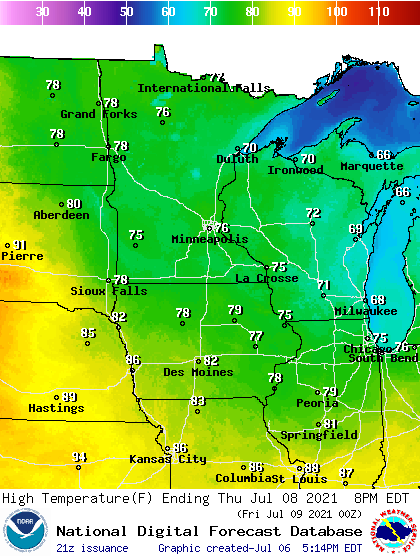
Highs will linger in the 60s north to 70s south Wednesday. Clouds will linger but gradually fade Wednesday.
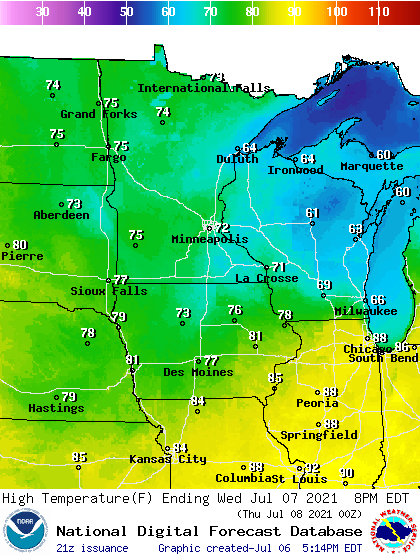
Thursday looks glorious across Minnesota. Brilliant sunshine and highs in the 70s will feel like a vacation after our recent string of 90s.
Dry air mass
Another pleasant feature of our inbound air mass is dryness. Dew points will be in the 30s and 40s up north, with comfortable 50s in the south.

Enjoy our free AC for the next few days.

