
Widespread significant rainfall may be a crop-saver for farmers
1 to 2 inches of rain across much of central and southern Minnesota Tuesday.

Go Deeper.
Create an account or log in to save stories.
Like this?
Thanks for liking this story! We have added it to a list of your favorite stories.


This wasn’t just another rain. Tuesday’s widespread rainfall may be a crop-saver for many Minnesota farmers.
Significant rains fell across much of central and southern Minnesota Tuesday. While rainfall coverage is typically selective in summer thunderstorms, a lot of territory in Minnesota picked up 1 to 2 inches of rainfall.
You can see the areas of deep green and yellow on the map above that indicate areas between 1 and 2 inches of rainfall. Smaller orange-colored blips show more than 2 inches of rain fell in parts of southern Minnesota near the Interstate 90 corridor.
Here’s a list of the highest rainfall totals in Minnesota Tuesday. Click the link to see rainfall totals near you.
Turn Up Your Support
MPR News helps you turn down the noise and build shared understanding. Turn up your support for this public resource and keep trusted journalism accessible to all.

Critical rainfall
During my recent vacation I traveled from southwestern Minnesota all the way to the North Shore near Grand Marais. It’s easy to see how dry fields are across Minnesota. Rivers and lakes are near record lows in some areas.
Tuesday’s Minnesota crop report from the United States Department of Agriculture shows 78 percent of topsoil in Minnesota is short or very short of moisture.
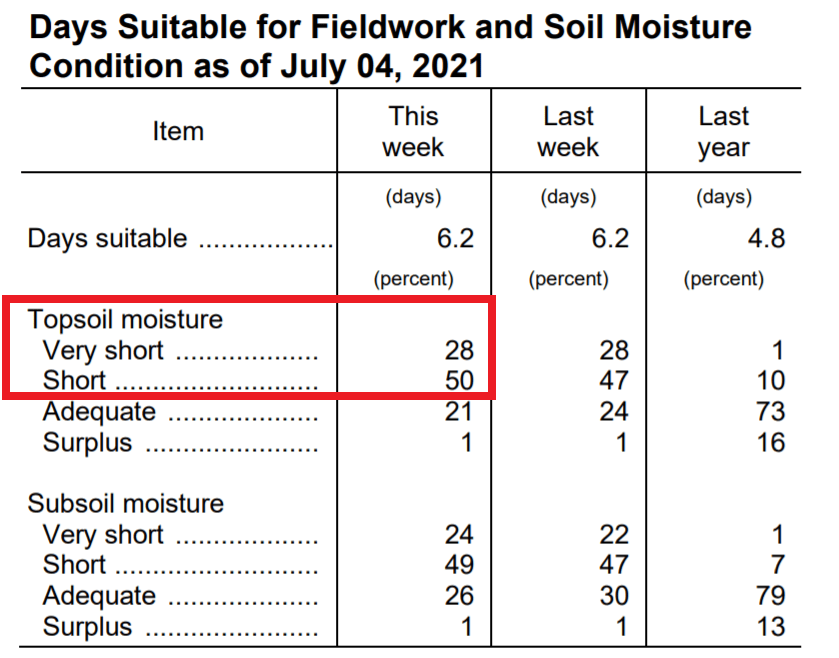
Many crops have been getting along in stored soil moisture, and that has been going fast in our hot, dry summer. Tuesday’s well-timed rains and our cooler weather this week may be a crop-saver for many Minnesota fields.
Drought still in place
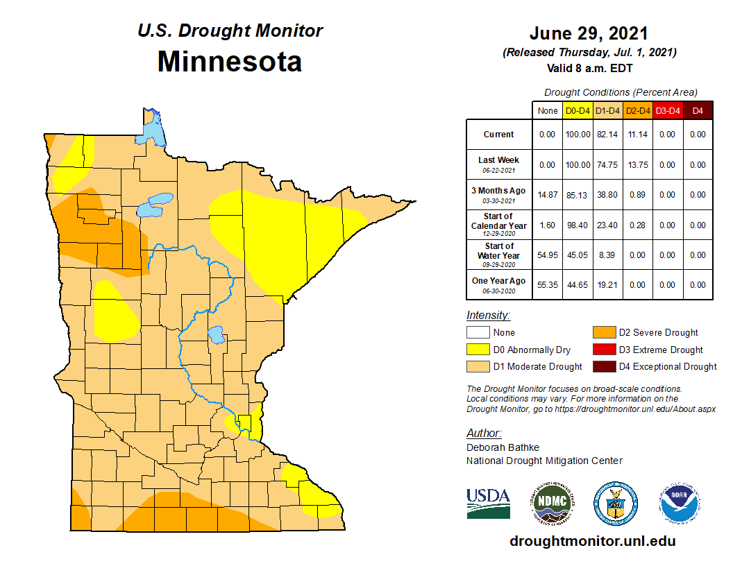
One day of rain will not bust the ongoing drought in Minnesota. Eighty-two percent of Minnesota is in drought as of last week’s U.S. Drought Monitor; 11 percent is listed in severe drought.
Unfortunately, the bulk of Tuesday’s rains will not make the 8 a.m. cutoff for precipitation factored into this week’s drought monitor. So expect this week’s update to look very similar to last week’s map.
Wednesday’s forecast models have trended toward steering Friday’s possible rainfall south of Minnesota. We need more rain, but right now the usually trusty European and most other forecast models predict little rain through the upcoming weekend.
Stay tuned.

