
Stormy Wednesday: Severe risk, potentially heavy rains likely
Another shot of beneficial rainfall may come with a side of severe weather.
Go Deeper.
Create an account or log in to save stories.
Like this?
Thanks for liking this story! We have added it to a list of your favorite stories.


We still need rain in much of Minnesota. This week’s opportunity for widespread significant rainfall comes with a price. There is a risk for heavy rainfall and severe weather as the system approaches Wednesday.
The system
Forecast models have been picking up on a low-pressure system passing through southern Minnesota or Iowa this Wednesday for several days now.
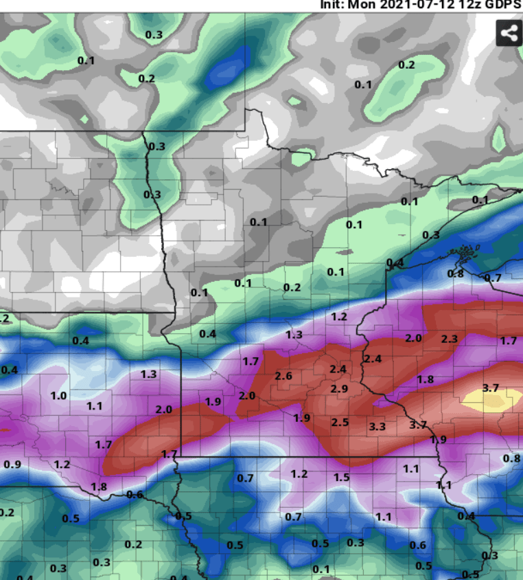
Monday’s model runs suggest the system will produce widespread rain and thunder across the southern half of Minnesota, northern Iowa, and Wisconsin.
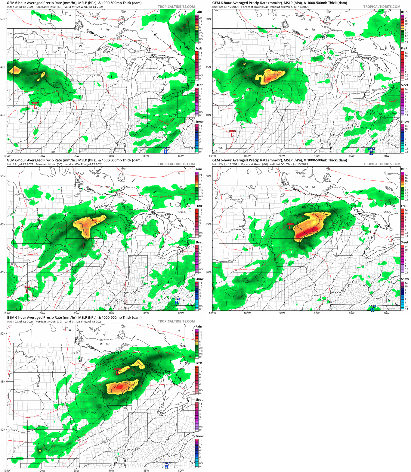
Right now the Canadian model takes the middle ground between the American (farther south) and European (farther north) models in laying out storms and potentially heavy rainfall across southern Minnesota Wednesday.
Turn Up Your Support
MPR News helps you turn down the noise and build shared understanding. Turn up your support for this public resource and keep trusted journalism accessible to all.
Heavy rainfall potential
This system looks likely to tap a deep pool of summer moisture lying to the south of Minnesota. Check out the sea of tropical dew points in the upper 60s and 70s lying in wait just a few hundred miles south and southeast of Minnesota.

Rain and thunderstorm coverage looks spotty Tuesday evening. But as the system pulls in deeper moisture Wednesday, rain and thunder will be widespread with potentially slow-moving heavy thunderstorms.
Forecast models rainfall varies as usual between models. Right now the Canadian model seems a good blend, and lays out widespread 1- to 3-inch rainfall totals across much of southern Minnesota including the Twin Cities by Thursday.
Here’s the latest Twin Cities National Weather Service rainfall projection.
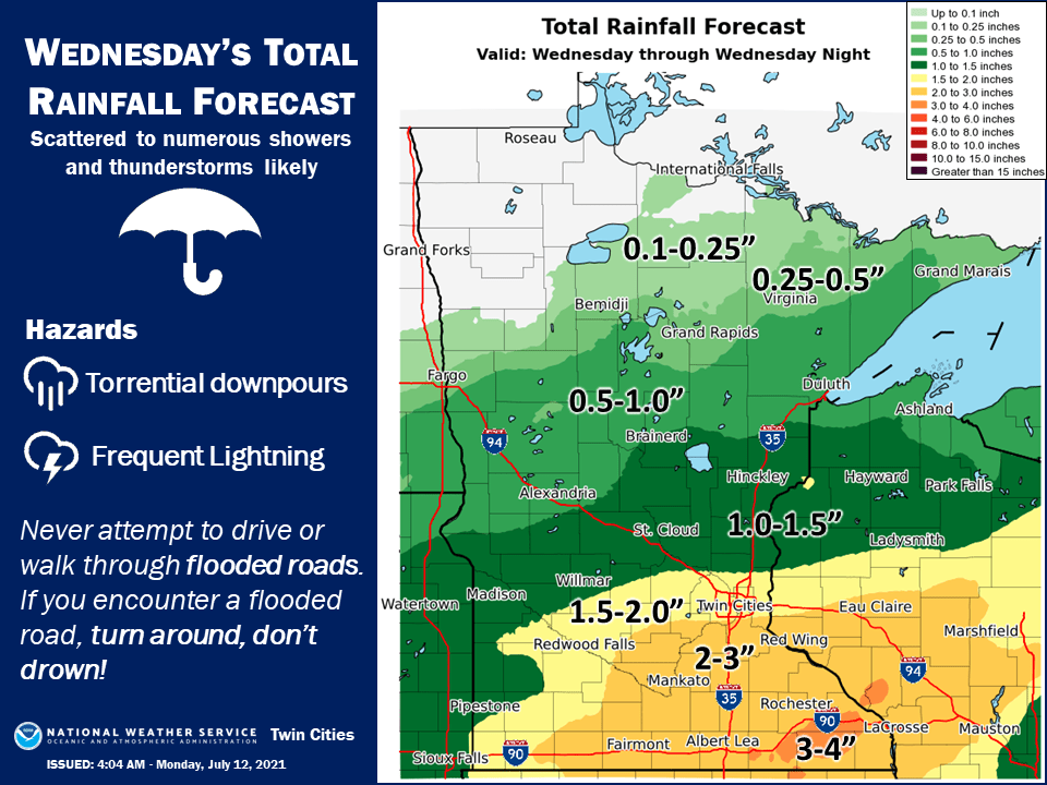
It should be noted that some models like the European suggest there could be localized 3- to 5-inch rainfall pockets Wednesday. This seems reasonable given the deep tropical moisture pooling to the south.
Severe risk
There’s also the risk that some storms could be severe packing high winds and hail. There’s a marginal risk for most of eastern and southern Minnesota Tuesday. But a higher slight risk zone covers the southern half of Minnesota and parts of Iowa and Wisconsin Wednesday.
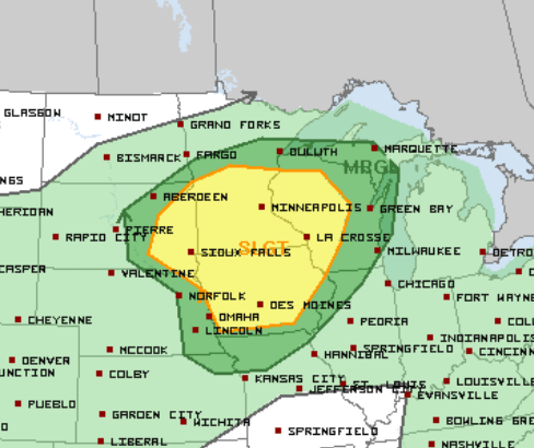
The National Oceanic and Atmospheric Administration’s Storm Prediction Center is already alerting on the potential for squall-line type systems packing damaging winds Wednesday.
Coupled with a strengthening and expanding cold pool, along with the strengthening wind fields, there still appears potential for the evolution of a large and sustained, organized and forward (northeastward/eastward) propagating convective system. This could be accompanied by swaths of damaging wind gusts, and the environment may become conditionally conducive to a number of embedded mesovortices along the gust front, accompanied by the risk for tornadoes. If current trends in model output persist, and lingering uncertainties clear, severe weather probabilities will need to be increased in later outlooks for this period.
Keep an eye out for potentially strong to severe storms late Tuesday, and especially Wednesday packing high winds, possible hail, and heavy to locally flooding rains.

