
Hazy, hot and humid through Friday
Multi-inch rainfall possible in some drought areas. Severe risk Friday night.

Go Deeper.
Create an account or log in to save stories.
Like this?
Thanks for liking this story! We have added it to a list of your favorite stories.


Day 23.
Wednesday’s high temperatures hit 90 degrees at the Minneapolis-St. Paul International Airport. That’s the 23rd day this year of 90-degree heat in the Twin Cities. That blows away the 30-year annual average (1981-2010) of 11 days of 90-degree heat.
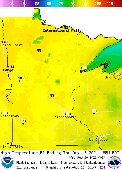
Our steamy late summer air mass persists through Friday. Highs will again push past the 90-degree mark across much of Minnesota again Thursday.
Dew points remain in the sticky 60s and tropical 70s once again Thursday.

Severe risk Friday
Friday brings scattered showers and some strong thunderstorms, especially in western Minnesota. NOAA’s Storm Prediction center paints a slight risk for severe storms across most of Minnesota late Friday and Friday night.
The best chance for multi-inch rainfall favors western Minnesota Friday. The Twin Cities and eastern Minnesota will likely see less rain overall.

Stay tuned as we watch for forecast model changes for Friday’s inbound weather system.
Turn Up Your Support
MPR News helps you turn down the noise and build shared understanding. Turn up your support for this public resource and keep trusted journalism accessible to all.

