Flash flood watch includes Twin Cities: Additional waves of heavy rain
Flash flood watch includes St. Cloud and the Twin Cities. 3 inches of rain possible in some locations overnight.

Go Deeper.
Create an account or log in to save stories.
Like this?
Thanks for liking this story! We have added it to a list of your favorite stories.


A flash flood watch has been issued until 7 a.m. for much of central Minnesota including St. Cloud, Willmar and the greater Twin Cities area.
Including the cities of Le Sueur, St Paul, Sauk Rapids, Chanhassen, Elk River, Albert Lea, St Cloud, Gaylord, Waseca, Mankato, Shakopee, Monticello, Victoria, Faribault, Chaska, Stillwater, Willmar, Litchfield, Hutchinson, St Peter, Red Wing, Hastings, Minneapolis, Owatonna, Glenwood, Blaine, and Blue Earth
544 PM CDT Thu Aug 26 2021
...FLASH FLOOD WATCH IN EFFECT THROUGH FRIDAY MORNING...
The National Weather Service in the Twin Cities has issued a * Flash Flood Watch for portions of central Minnesota, east central Minnesota, south central Minnesota, southeast Minnesota and west central Minnesota, including the following counties, in central Minnesota, Benton, Kandiyohi, McLeod, Meeker, Sherburne, Sibley, Stearns and Wright. In east central Minnesota, Anoka, Carver, Dakota, Hennepin, Ramsey, Scott and Washington. In south central Minnesota, Blue Earth, Faribault, Freeborn, Le Sueur, Nicollet, Rice, Steele and Waseca. In southeast Minnesota, Goodhue. In west central Minnesota, Pope.
* Through Friday morning.
* A band of training thunderstorms is beginning to develop just south of I-94. This activity is likely to continue or become more widespread through the evening hours and produce areas of very heavy rain. Localized totals greater than 3 inches are possible, leading to the possibility of flash flooding.
* Flash flooding of creeks, streams, urban areas, and low lying areas is possible.
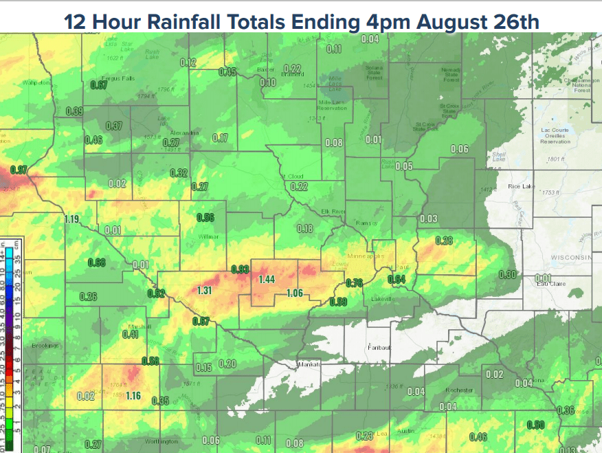
Thursday’s severe thunderstorms dumped brief but torrential rains across much of the Twin Cities. Many areas picked up close to or above a quick inch of rain.
Here’s a look at preliminary rainfall totals from Thursday’s storms.
That was just the first round. It looks like 2 to 3 more rounds of rain and thunder will visit much of Minnesota through the weekend.
Turn Up Your Support
MPR News helps you turn down the noise and build shared understanding. Turn up your support for this public resource and keep trusted journalism accessible to all.
Differences in timing
It’s been interesting, and a little frustrating to watch the short-range forecast models try and time out rain waves this week. That trend of model divergence continues as we look through Thursday evening into early Friday.
NOAA’s NAM 3 km resolution model brings another wave of strong storms with heavy rain through central Minnesota and the Twin Cities Thursday evening.
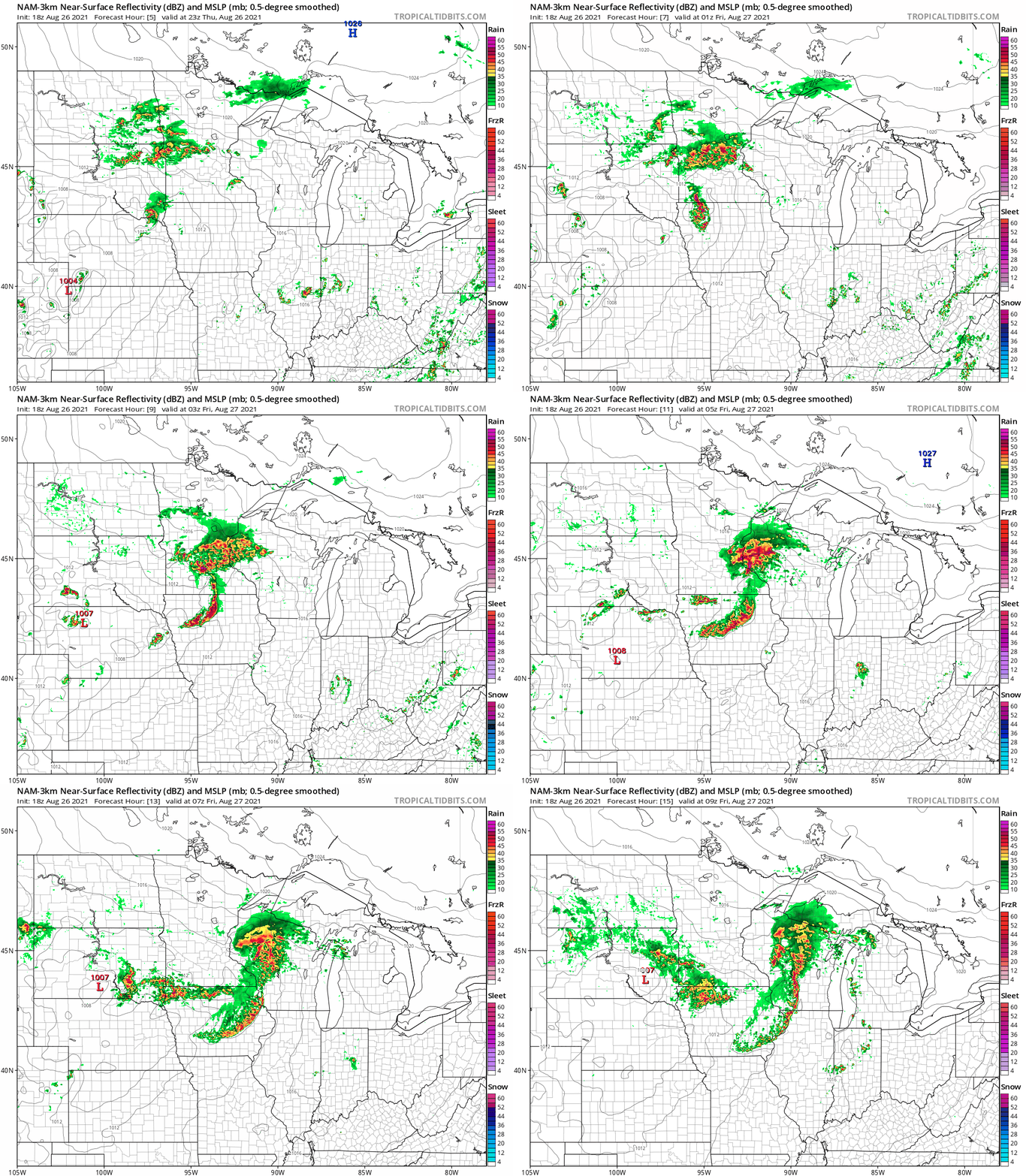
Other forecast models hold off the heaviest rainfall zone until after midnight into early Friday morning.
Either way, we’re likely to get another wave of heavy rainfall across central and southern Minnesota through Friday morning.
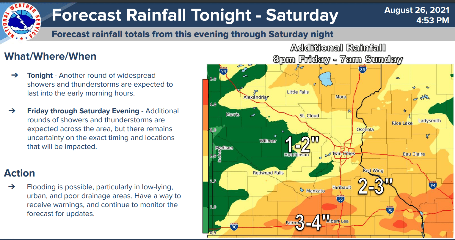
Additional waves of rain and thunder are likely Friday afternoon and again Saturday afternoon and evening.
In total, the Twin Cities and central Minnesota will likely see at least another 1” to 2” of rainfall. The heaviest rainfall signal remains across southern Minnesota, where an additional 3” to 4” of rain is likely to fall through Saturday night.