July-like heat sparks scattered storms into Friday morning
Here's a look at the most likely timing for storms through the overnight hours.

Go Deeper.
Create an account or log in to save stories.
Like this?
Thanks for liking this story! We have added it to a list of your favorite stories.


A warm July-like air mass is unstable enough to crank out scattered thunderstorms through Thursday evening and the overnight hours.
Temperatures surged into the mid and upper 80s across central and southern Minnesota Thursday afternoon. Montevideo, Minn., has reached 90 degrees and Redwood Falls is at 91 degrees as of this post time.

Our July-like heat comes with a side of slightly tropical air. Moisture is streaming northward from the Gulf of Mexico onto Minnesota, with a tongue of dew points in the 60s riding southerly breezes northward. This moisture is fuel for scattered storms.

Severe risk
NOAA’s Storm Prediction Center paints a slight severe risk from northern Minnesota southward. Roughly the northwest half of the Twin Cities is included in the slight risk zone, with the remainder of the Twin Cities under a marginal severe risk through 7 a.m. Friday.
Turn Up Your Support
MPR News helps you turn down the noise and build shared understanding. Turn up your support for this public resource and keep trusted journalism accessible to all.
Storm timing
Scattered storms will blossom across northern Minnesota into this evening. The Duluth National Weather Service has a good graphic showing the most likely timing of storms across northern Minnesota through this evening:

Twin Cities and southern Minnesota
The latest forecast model trends suggest a chance of storms approaching the northwest Twin Cities this evening after 8 or 9 p.m. if the northern storms are able to develop southward.
But the latest forecast model solutions now favor a second wave of storms developing in western Minnesota later this evening, then moving into the greater Twin Cities area after midnight.
So a few cells may possibly approach the Twin Cities late this evening, but it appears the better chance for storms will arrive after midnight into the overnight hours.
NOAA’s HRRR model is typical of those that fade the northern line, then push the second line toward the Twin Cities after midnight from the west.

How much rain?
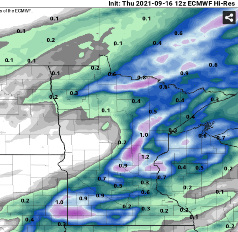
Rainfall coverage looks spotty again but will be significant under the stronger cells.
The European model paints larger areas of 0.25 to 0.5-inch rainfall, with some local totals at or above 1 inch through Friday.