
Any signs of the first frost for the Twin Cities?
We're approaching the average date of the first 32-degree temperature of fall.

Go Deeper.
Create an account or log in to save stories.
Like this?
Thanks for liking this story! We have added it to a list of your favorite stories.


“Hey Paul, when can we expect the first frost in the Twin Cities?”
That’s a question I get a lot this time of year.
And it’s a good question since we’re actually approaching the average date of the first 32-degree temperatures in the Twin Cities area.
Freezing temperatures have already occurred at several northern Minnesota locations. And it’s pretty typical to get frost up north in September.
Here’s a look at the average dates for the first 32-degree temperature in fall across Minnesota:
Turn Up Your Support
MPR News helps you turn down the noise and build shared understanding. Turn up your support for this public resource and keep trusted journalism accessible to all.

Here’s a wider look at the average first 32-degree temperatures around the Midwest:

Twin Cities approaching the average first 32-degree temperature
Weather records at the Minneapolis-St. Paul International Airport show the long-term average for the first 32-degree temperature in fall is about Oct. 8. Thanks to the urban heat island, most Twin Cities suburbs typically see the first frost earlier than the airport and downtown urban core of the Twin Cities.

In 2016 the first 32-degree temperature did not arrive until Nov. 18. That’s the latest on record and the longest growing season on record in the Twin Cities area. Here’s more on that record year from the Minnesota DNR Climate Working Group:
In 2016 the Twin Cities observed its longest frost-free season on record, tallying 219 consecutive days without a 32 degree F reading at the MSP Airport. The first such reading of the 2016 fall was also by far the latest on record, and did not come until Nov. 18 — 11 days later than the old record of Nov. 7, set in 1900. The Twin Cities "threaded" record for these purposes extends back to 1873.
No 32 in sight yet for Twin Cities
Looking at the weather maps, I don’t see any real chance of freezing temperatures for the Twin Cities for at least the next one to two weeks. The coldest temperatures in the next week for Minnesota arrive next Monday morning with lows in the 40s (and some isolated 30s) up north to near 50 in the Twin Cities.
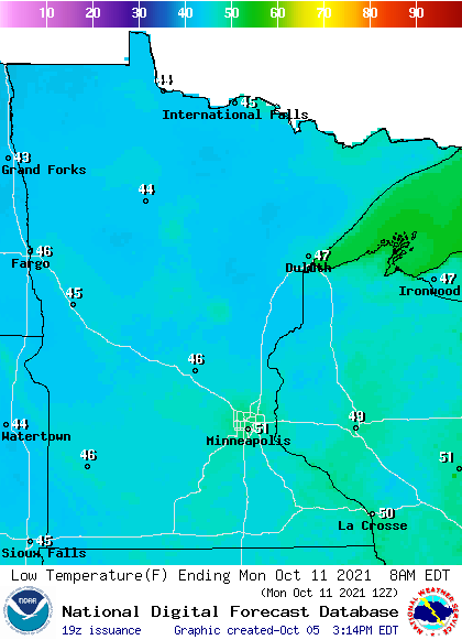
At this point, the coldest temperature the forecast models are cranking out so far for the Twin Cities is in the lower 40s around Oct. 16.
As of today, it appears our first 32-degree temperature in the Twin Cities area will come later than the longer-term average date of around Oct. 8. And looking at the maps today, it could be at least late October before we see freezing temperatures in the Twin Cities.
Stay tuned.

