Coldest night so far Tuesday, 60 again this weekend?

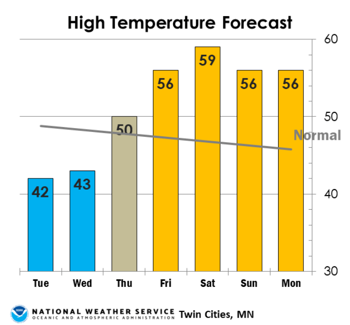
Forecast high temperatures for the Twin Cities area
Twin Cities National Weather Service

The first few days of November really feel like late autumn in Minnesota. But our frosty start to November gives way to milder temperatures again later this week.

Wednesday morning will be the coldest night so far this season for much of Minnesota. So far the coldest temperature this season at Minneapolis-St. Paul International Airport is 31 degrees on Oct. 23.

Lows should dip into the mid to upper-20s in the Twin Cities and southern Minnesota Wednesday morning. I won’t be surprised to see lows in the teens up north in the colder nooks and crannies like Embarrass and Tower.

Forecast minimum temps Wednesday
NOAA

Warming trend ahead

Our chilly high-pressure system slides east of Minnesota the rest of this week. That opens the door to milder southerly breezes as we move toward the weekend. Highs will climb through the 50s, and a few of the forecast models I trust suggest more 60s in the Twin Cities and southern Minnesota by Sunday afternoon.

Forecast high temperatures Sunday
NOAA GFS temperature output for noon Sunday
NOAA via tropical tidbits

NOAA’s six to 10-day outlook strongly favors milder than average temperatures as we move into the second week of November.

NOAA 6 to 10-day temperature outlook
NOAA six to 10-day temperature outlook
NOAA

Rain or snow next week?

Minnesota’s weather pattern looks basically dry through early next week. A few forecast models suggest a system that could bring a mix of rain and snow to parts of Minnesota around the middle of next week.

Stay tuned.

Create a More Connected Minnesota

MPR News is your trusted resource for the news you need. With your support, MPR News brings accessible, courageous journalism and authentic conversation to everyone - free of paywalls and barriers. Your gift makes a difference.