Gradually colder; weekend snow chance up north
Potentially plowable snow for northern Minnesota this weekend.
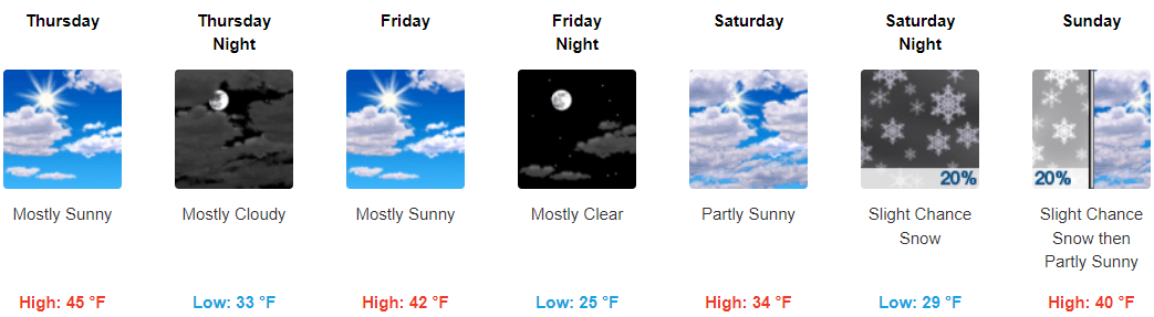
Cold fronts lately are just not what they used to be in Minnesota.
Two cool fronts sag southward across Minnesota Thursday.
They will deliver an air mass about 10 degrees colder than Wednesday, but temperatures will still hover about 10 degrees above average for Dec. 2 in southern Minnesota. Highs will be in the 40s and 50s in southern Minnesota with 30s up north.
Keep in mind the average high temperature for this week is around 34 degrees in the Twin Cities. Our mild fall has skewed our normal weather perspective lately.
Create a More Connected Minnesota
MPR News is your trusted resource for the news you need. With your support, MPR News brings accessible, courageous journalism and authentic conversation to everyone - free of paywalls and barriers. Your gift makes a difference.
Overall the forecast for southern Minnesota looks fairly quiet through the upcoming weekend. Temperatures will gradually chill down into the more seasonable 30s by the weekend, with 20s in northern Minnesota.
Weekend snow chance up north
Now, let’s talk about snow. Most forecast models are moving a weather system through northern Minnesota this weekend that could produce significant snow. The precise track of the system is still uncertain, but the majority of forecast model solutions do bring possible accumulations north of a Fargo to Duluth line.
Here’s the National Oceanic and Atmospheric Administration’s GFS model run.
If this scenario verifies, much of northern Minnesota could see potentially plowable snowfall this weekend. The Twin Cities would be on the southern edge of the system, with little accumulation likely and maybe a few snow showers.
Stay tuned as we watch the new forecast model runs Thursday.