Winter storm likely brings heavy snow to northern Minnesota this weekend

Forecast models suggest 5 inches to 10-plus inches will fall across northern Minnesota

Snowfall projection
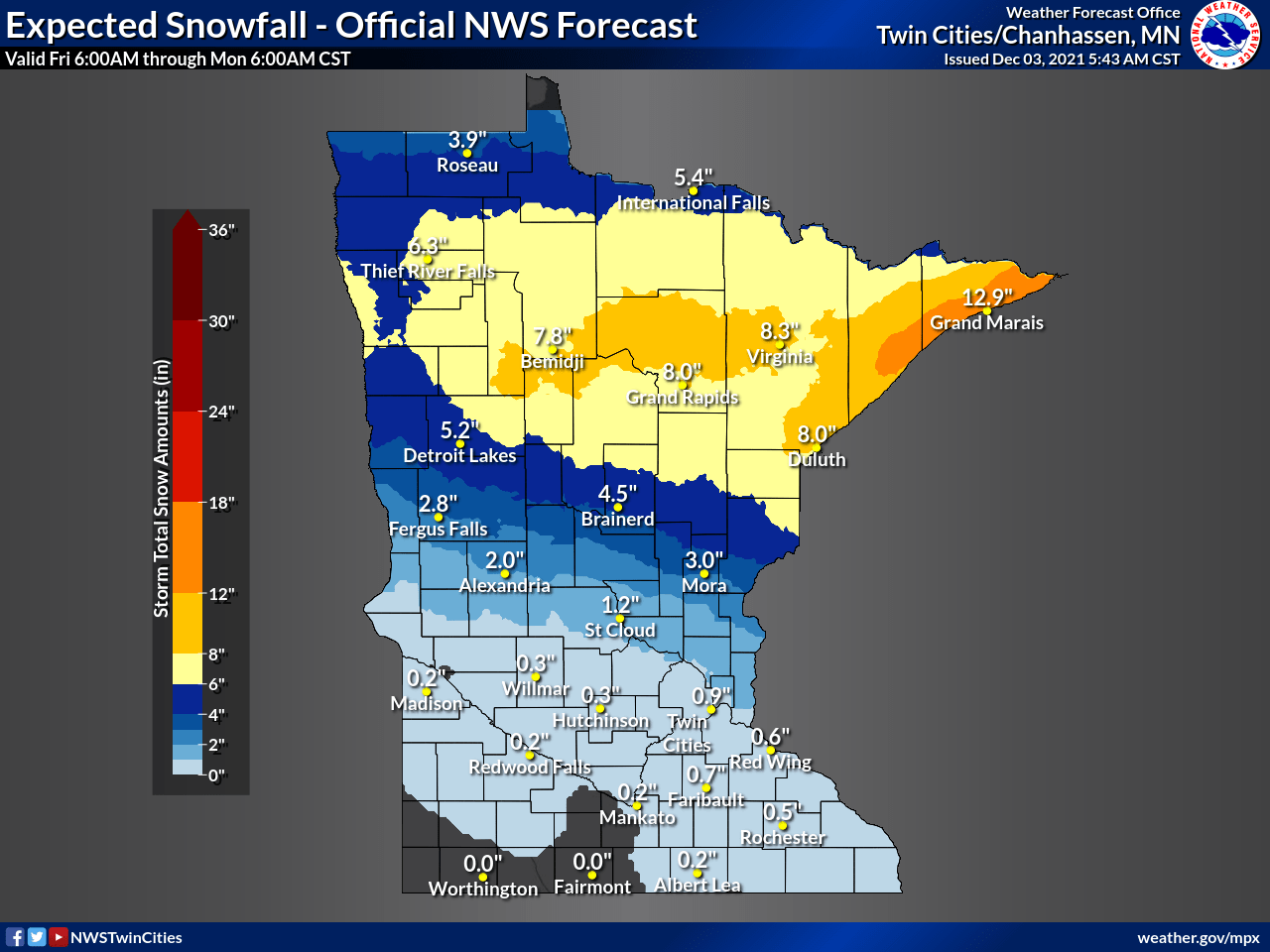
Snowfall projection by Monday.
NOAA

December is ready to forcefully announce itself in the northern half of Minnesota this weekend.

A potent winter storm takes aim at the northland. Winter storm watches cover all of northern Minnesota, basically along and north of a Fargo, N.D., to Duluth line.

Winter storm watch
Winter storm watch.
Duluth National Weather Service

Here are the watch zone details for northwest Minnesota from the Grand Forks National Weather Service office.

Including the cities of Crookston, East Grand Forks, Ada, Twin Valley, Halstad, Hallock, Karlstad, Lancaster, Roseau, Warroad, Greenbush, Baudette, Warren, Stephen, Argyle, Newfolden, Middle River, Grygla, Red Lake, Redby, Ponemah, Thief River Falls, Red Lake Falls, Fosston, Fertile, McIntosh, Erskine, Bagley, Clearbrook, Bemidji, Mahnomen, Naytahwaush, Waubun, Alida, Ebro, Lake Itasca, Long Lost Lake, Lower Rice Lake, Roy Lake, Upper Rice Lake, Park Rapids, Detroit Lakes, Wolf Lake, Cando, Langdon, Cavalier, Walhalla, Drayton, Pembina, Neche, St. Thomas, Fort Totten, Maddock, Leeds, Minnewaukan, Devils Lake, Grafton, Park River, New Rockford, Lakota, Mcville, Aneta, Tolna, Grand Forks, Cooperstown, Finley, Hope, Mayville, Hillsboro, Hatton, Portland, Edinburg, Adams, and Lankin

322 AM CST Fri Dec 3 2021

...WINTER STORM WATCH IN EFFECT FROM SATURDAY EVENING THROUGH SUNDAY AFTERNOON...

* WHAT...Heavy snow possible. Total snow accumulations of 6 inches or greater possible. Winds could gust as high as 40 mph late Sunday morning into Sunday afternoon.

* WHERE...Portions of north central and northwest Minnesota and northeast and east central North Dakota.

* WHEN...From Saturday evening through Sunday afternoon.

* IMPACTS...Travel could be very difficult. Patchy blowing snow could significantly reduce the visibility.

Here are the watch zone details for northeast Minnesota from the Duluth National Weather Service office.

Political Coverage Powered by You

Your gift today creates a more connected Minnesota. MPR News is your trusted resource for election coverage, reporting and breaking news. With your support, MPR News brings accessible, courageous journalism and authentic conversation to everyone - free of paywalls and barriers. Your gift makes a difference.

Including the cities of Ely, Isabella, Hibbing, Two Harbors, Silver Bay, Grand Marais, Duluth, Superior, Washburn, Bayfield, Ashland, and Hurley

324 AM CST Fri Dec 3 2021

...WINTER STORM WATCH IN EFFECT FROM LATE SATURDAY NIGHT THROUGH LATE SUNDAY NIGHT...

* WHAT...Heavy snow possible. Total snow accumulations of 6 or more.

* WHERE...Portions of northwest Wisconsin and northeast Minnesota.

* WHEN...From late Saturday night through late Sunday night.

* IMPACTS...Travel could be very difficult to impossible.

* ADDITIONAL DETAILS...There is some uncertainty on storm track therefore snow amounts could change. The greatest confidence is along the North Shore exceeding 8 inches or more. Blowing and drifting snow is also possible along the North Shore as winds increase mid-morning Sunday.

The system

A potent low-pressure system is moving through the Upper Midwest this weekend. Forecast models are in better agreement Friday regarding a storm track that will place the heaviest snow zone across northern Minnesota late Saturday and Sunday.

NOAA’s GFS model pushes an arm of light snow through central Minnesota Saturday evening, then blankets the northern half of Minnesota with steadier, accumulating snows Saturday night through Sunday.

NOAA GFS model 6 pm Saturday to midnight Monday
NOAA GFS model 6 pm Saturday to midnight Monday.
NOAA via tropical tidbits

Overall snowfall totals still favors a zone of 5 to 10 inches across most of northern Minnesota. There could be some local totals in excess of 10 inches, especially along the ridge above the North Shore. It appears possible that locations like Lutsen, Minn., and Finland, Minn., could pick up more than a foot of snow with this system.

The Twin Cities area looks most likely to see occasional rain and snow, with all snow and some lighter accumulation of an inch or two Sunday night.

Here’s NOAA’s GFS snowfall output.

NOAA GFS snowfall output
NOAA GFS snowfall output by Monday.
NOAA via pivotal weather

Another way of expressing potential snowfall totals is by percentages. Here’s the percent chance of more than 4 and 6 inches of snow from the Duluth NWS office.

Snowfall percentages
Snowfall percentages.
Duluth National Weather Service

Key forecast points

  • A significant winter storm is on the way for northern Minnesota this weekend.

  • Snow will begin Saturday evening and increase Saturday night.

  • The heaviest snowfall rates will occur late Saturday night and Sunday.

  • More than 6 inches of snow is likely across northern Minnesota by late Sunday.

  • Strong northwest winds will cause blowing snow by Sunday night.

  • Travel impacts will be widespread across northern Minnesota this weekend.

  • Subzero temperatures are likely behind the storm Monday and Tuesday morning across northern Minnesota.

Stay tuned as we watch the evolution of this system through the weekend.