
Arctic again: Twin Cities could hit 17 below Wednesday morning
Temps moderate by the weekend, with highs in the teens and 20s above zero

Go Deeper.
Create an account or log in to save stories.
Like this?
Thanks for liking this story! We have added it to a list of your favorite stories.


Here we go again.
Another arctic swipe blows through Minnesota into Wednesday morning. The core of this latest subzero air mass will only last about 40 hours for most of Minnesota.
Temperatures could challenge the coldest readings so far this winter in the Twin Cities Wednesday morning. The coldest temperature recorded so far this winter at the Minneapolis-St. Paul International Airport is 17 below zero on Jan. 7.
Wind chill warnings
Wind chill warnings cover a huge chunk of Minnesota through Wednesday morning. The warnings zone runs from northwest Minnesota through south-central Minnesota to the Iowa border.
Turn Up Your Support
MPR News helps you turn down the noise and build shared understanding. Turn up your support for this public resource and keep trusted journalism accessible to all.
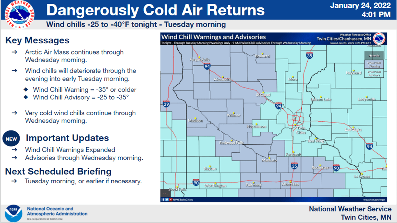
Including the cities of Crookston, East Grand Forks, Ada, Twin Valley, Halstad, Moorhead, Hallock, Karlstad, Lancaster, Roseau, Warroad, Greenbush, Baudette, Warren, Stephen, Argyle, Newfolden, Middle River, Grygla, Red Lake, Redby, Ponemah, Thief River Falls, Red Lake Falls, Fosston, Fertile, McIntosh, Erskine, Bagley, Clearbrook, Bemidji, Mahnomen, Naytahwaush, Waubun, Alida, Ebro, Lake Itasca, Long Lost Lake, Lower Rice Lake, Roy Lake, Upper Rice Lake, Park Rapids, Detroit Lakes, Wolf Lake, Breckenridge, Fergus Falls, Perham, New York Mills, Parkers Prairie, Henning, Battle Lake, Wadena,
116 PM CST Mon Jan 24 2022
...WIND CHILL WARNING REMAINS IN EFFECT FROM 9 PM THIS EVENING TO NOON CST TUESDAY...
* WHAT...For the Wind Chill Warning, dangerously cold wind chills expected. Wind chills as low as 50 below zero. For the Wind Chill Advisory, very cold wind chills expected. Wind chills as low as 40 below zero.
* WHERE...Portions of central, north central, northwest and west central Minnesota and northeast and southeast North Dakota.
* WHEN...For the Wind Chill Warning, from 9 PM this evening to noon CST Tuesday. For the Wind Chill Advisory, until 9 PM CST this evening.
* IMPACTS...The dangerously cold wind chills could cause frostbite on exposed skin in as little as 10 minutes.
Wind chill advisories cover the rest of Minnesota.
Including the cities of Princeton, Mora, Elk River, Cambridge, Center City, Monticello, Minneapolis, Blaine, St Paul, Stillwater, Chanhassen, Chaska, Victoria, Shakopee, Hastings, Faribault, Red Wing, Osceola, Rice Lake, Ladysmith, Hudson, River Falls, Menomonie, Durand, Chippewa Falls, and Eau Claire
312 PM CST Mon Jan 24 2022
...WIND CHILL ADVISORY REMAINS IN EFFECT FROM 9 PM THIS EVENING TO 10 AM CST WEDNESDAY...
* WHAT...Very cold wind chills expected. Wind chills as low as 35 below zero.
* WHERE...Portions of northwest and west central Wisconsin and central, east central, south central and southeast Minnesota.
* WHEN...From 9 PM this evening to 10 AM CST Wednesday.
* IMPACTS...The dangerously cold wind chills could cause frostbite on exposed skin in as little as 10 minutes.
Temperatures Tuesday morning will tickle minus 30 once again in parts of northern Minnesota. Most of southern Minnesota will bottom out between minus 10 and minus 18 Tuesday.
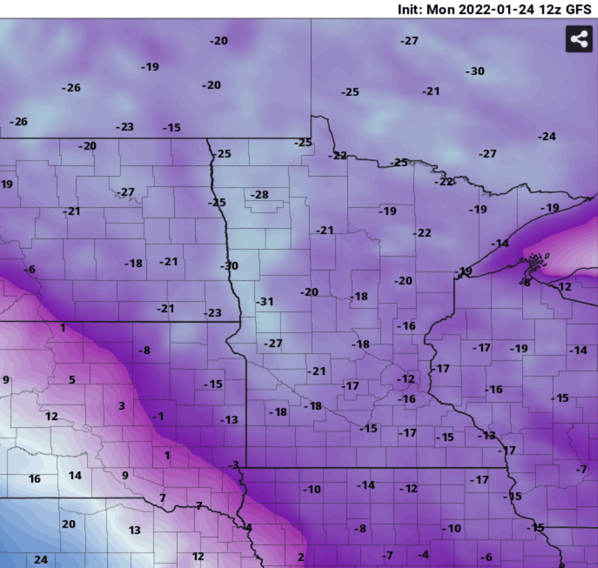
The core of the coldest air with this outbreak will slide across southern Minnesota early Wednesday. Lows will reach minus 15 to minus 20 across southern Minnesota. Temperatures in northern Minnesota will moderate slightly by early Wednesday.
Temperatures moderate by this weekend with highs in the teens and 20s above zero.
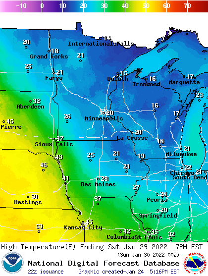
Note the persistent appearance of relative warmth again in Nebraska and Kansas with temperatures in the 50s Sunday. There is little snow cover from Sioux Falls, S.D., south and west. While it’s been a real winter in Minnesota, winter has yet to really take consistent hold in the central plains.

