
Next arctic front blows in Tuesday, three more subzero mornings this week
Winter storm warnings up for the Red River Valley. Gusty Tuesday ahead.
Go Deeper.
Create an account or log in to save stories.
Like this?
Thanks for liking this story! We have added it to a list of your favorite stories.


February arrives Tuesday. Our first arctic front of the month arrives right on schedule.
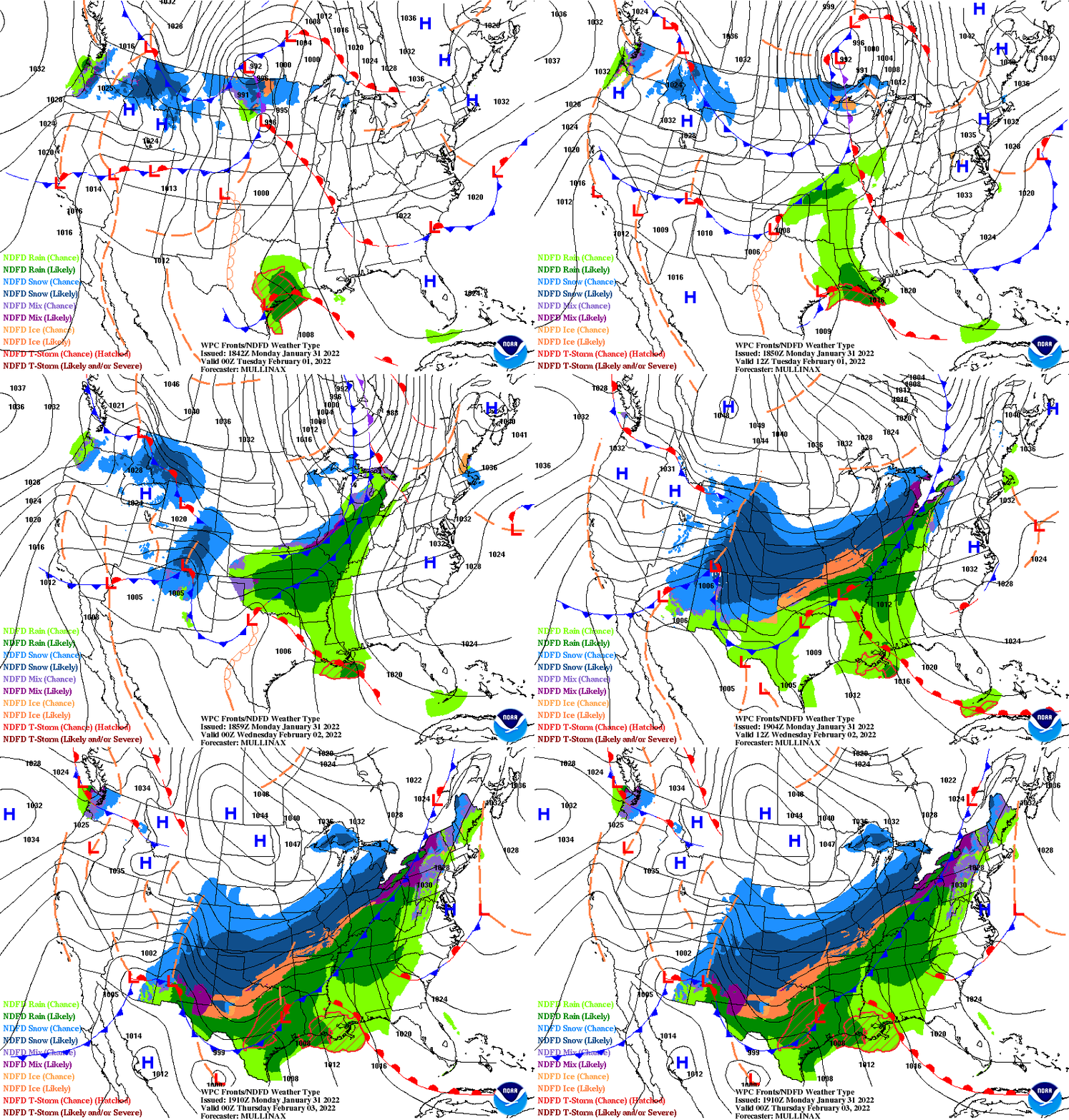
NOAA’s 2.5-day surface animation shows the arctic front blowing through Minnesota by Tuesday, with another large and very cold arctic high-pressure cell diving into Minnesota by Wednesday. Also, note the massive snow — and ice — swath that will spread through the central and northeast U.S. this week.
Winter storm warning for Red River Valley
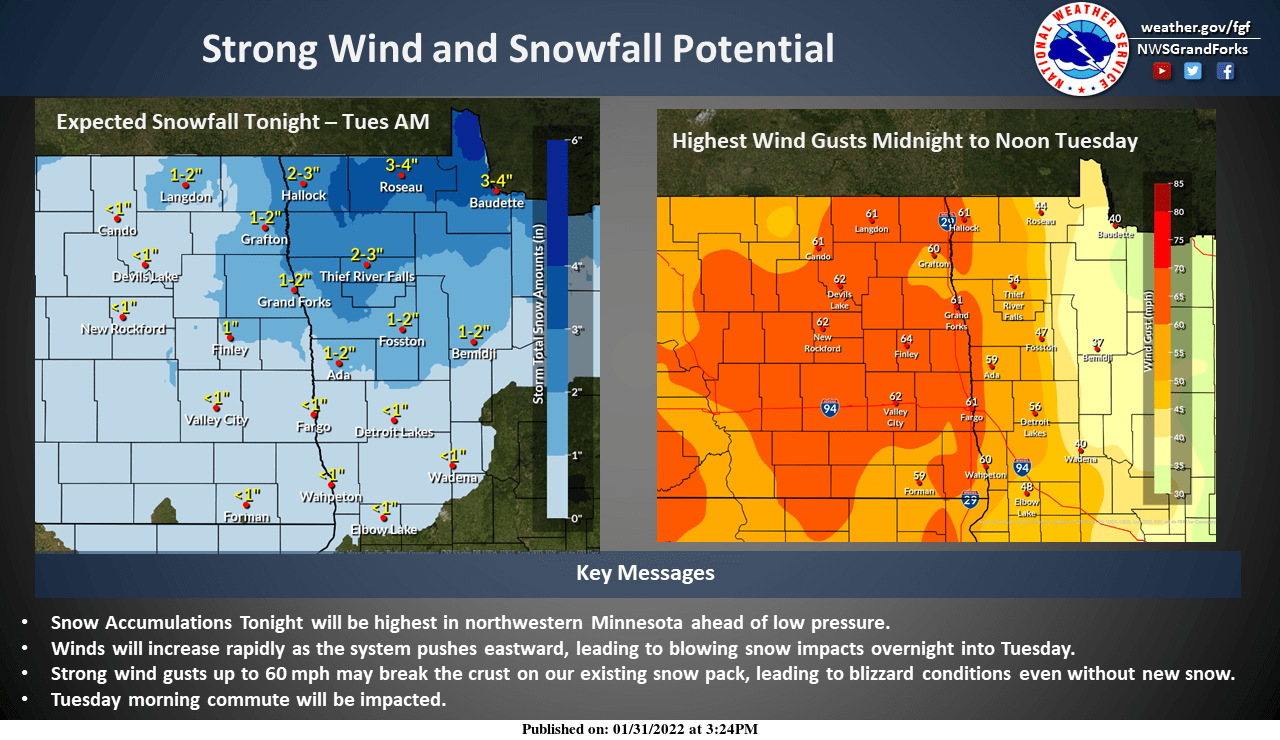
The arctic front will bring an inch or two of snow to northern Minnesota overnight. But winds gusting to 55 mph in the open areas of the Red River Valley will produce severe blowing snow and reduced visibilities at times.
Including the cities of Crookston, East Grand Forks, Ada, Twin Valley, Halstad, Moorhead, Hallock, Karlstad, Lancaster, Roseau, Warroad, Greenbush, Warren, Stephen, Argyle, Breckenridge, Cavalier, Walhalla, Drayton, Pembina, Neche, St. Thomas, Grafton, Park River, Lakota, Mcville, Aneta, Tolna, Grand Forks, Cooperstown, Finley, Hope, Mayville, Hillsboro, Hatton, Portland, Valley City, Fargo.
332 PM CST Mon Jan 31 2022
...WINTER STORM WARNING REMAINS IN EFFECT UNTIL 3 PM CST TUESDAY...
* WHAT...A period of snow expected this evening, possibly mixed with freezing rain or sleet. Total snow accumulations of up to two inches. After midnight look for strong west to northwest winds gusting over 50 mph creating reduced visibilities in blowing snow.
* WHERE...Portions of northwest and west central Minnesota and northeast and southeast North Dakota.
* WHEN...From 6 PM this evening to 3 PM CST Tuesday.
* IMPACTS...Plan on slippery road conditions. Widespread blowing snow could significantly reduce visibility. The hazardous conditions could impact the morning commute. The cold wind chills as low as 25 below zero could cause frostbite on exposed skin in as little as 30 minutes.
Three subzero mornings
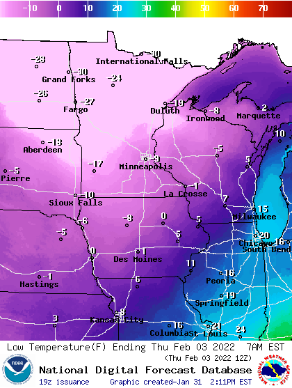
Temperatures hold fairly steady overnight into early Tuesday for much of Minnesota. Then temperatures will plunge by Tuesday evening. We’re in for three more nights of subzero weather between Tuesday and Friday morning. The coldest morning arrives Thursday with temperatures around 10 below zero in the Twin Cities to 30 below up north.
Weekend warm up
At least we’re timing the cold snaps during the week, with milder weekends for outdoor winter play. Highs return to the 20s above zero this weekend in southern Minnesota, with teens up north.

Good timing for most Minnesotans.
Turn Up Your Support
MPR News helps you turn down the noise and build shared understanding. Turn up your support for this public resource and keep trusted journalism accessible to all.

