
Arctic adventure: Wind chill advisories and warnings again into Thursday morning
Our latest cold blast brings another round of bitter subzero wind chills
Go Deeper.
Create an account or log in to save stories.
Like this?
Thanks for liking this story! We have added it to a list of your favorite stories.


We’re headed for the bottom of our latest temperature roller coaster ride Thursday morning.
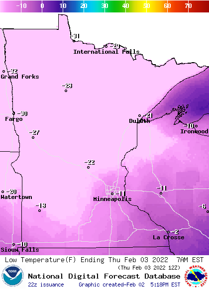
Temperatures will be subzero across all of Minnesota once again Thursday morning. It will be all of 30 below zero across the north, with lows around 10 below in the inner Twin Cities urban 494/694 freeway loop. Many Twin Cities suburbs will see lows in the teens below zero.
Wind chill warnings and advisories
Another round of wind chill warnings and advisories cover Minnesota into Thursday morning.
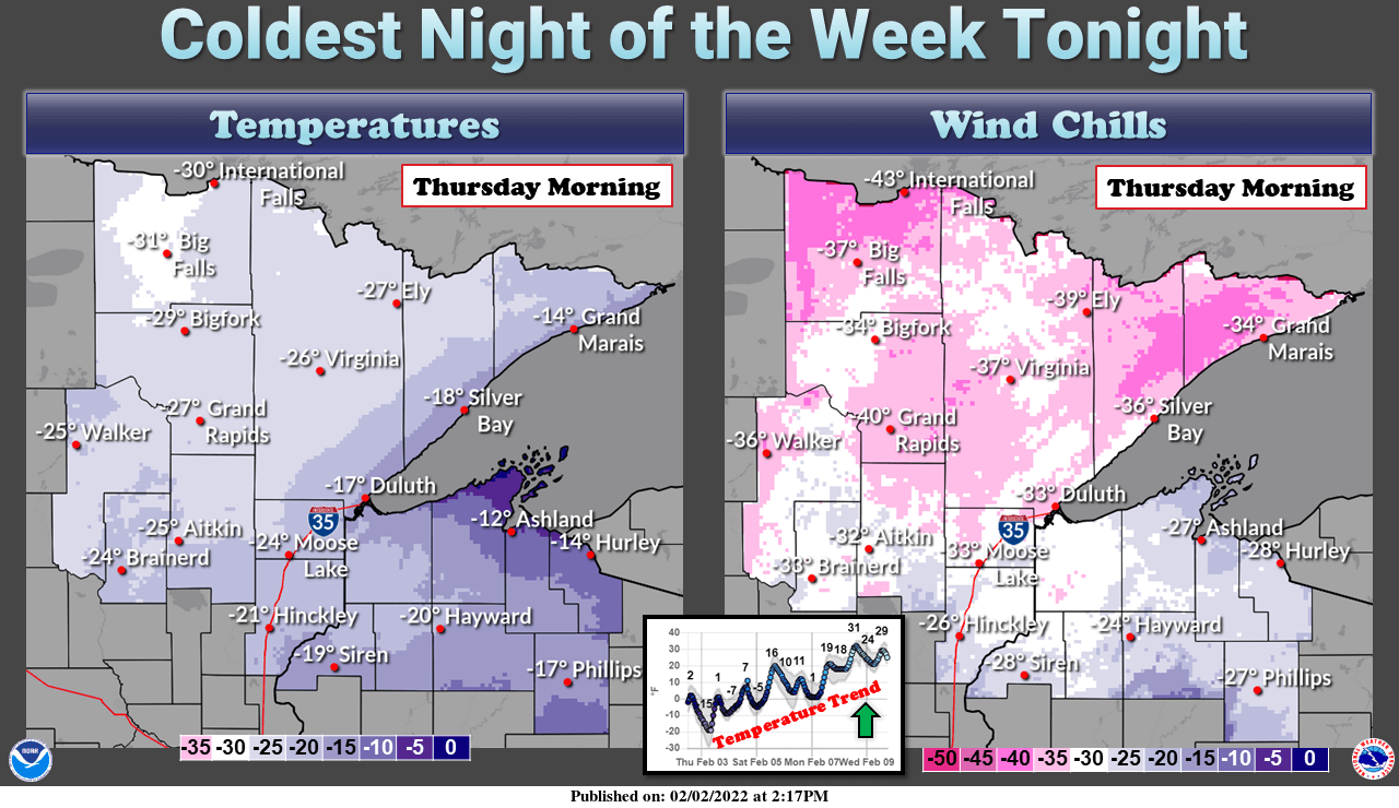
It seems like we get numb to frequent wind chill warnings in Minnesota. But the graphic text in the wind chill warning for the Red River Valley and northwest Minnesota is a good reminder. Your exposed skin can freeze in 5 minutes at a wind chill of around minus 50.
Including the cities of Crookston, East Grand Forks, Ada, Twin Valley, Halstad, Moorhead, Hallock, Karlstad, Lancaster, Roseau, Warroad, Greenbush, Baudette, Warren, Stephen, Argyle, Newfolden, Middle River, Grygla, Red Lake, Redby, Ponemah, Thief River Falls, Red Lake Falls, Fosston, Fertile, McIntosh, Erskine, Bagley, Clearbrook, Mahnomen, Naytahwaush, Waubun, Alida, Ebro, Lake Itasca, Long Lost Lake, Lower Rice Lake, Roy Lake, Upper Rice Lake, Detroit Lakes, Breckenridge, Cando, Langdon, Cavalier, Walhalla, Drayton, Pembina, Neche, St. Thomas, Fort Totten, Maddock, Leeds, Minnewaukan, Devils Lake, Grafton, Park River, New Rockford, Lakota, Mcville, Aneta, Tolna, Grand Forks, Cooperstown, Finley, Hope, Mayville, Hillsboro, Hatton, Portland, Valley City, Fargo, Lisbon, Enderlin, Gwinner, Milnor, Forman, Rutland, Wahpeton, Edinburg, Adams, and Lankin 336 PM CST Wed Feb 2 2022 ...WIND CHILL ADVISORY REMAINS IN EFFECT UNTIL 6 PM CST THIS EVENING... ...WIND CHILL WARNING REMAINS IN EFFECT UNTIL NOON CST THURSDAY... * WHAT...Wind chills as low as 40 below zero through 6 PM CST this evening, then wind chills as low as 55 below zero from 6 pm through noon Thursday. * WHERE...Portions of north central, northwest and west central Minnesota and northeast and southeast North Dakota. * WHEN...For the Wind Chill Warning, from 6 PM this evening to noon CST Thursday. For the Wind Chill Advisory, until 6 PM CST this evening. * IMPACTS...The dangerously cold wind chills could cause frostbite on exposed skin in as little as 5 minutes.
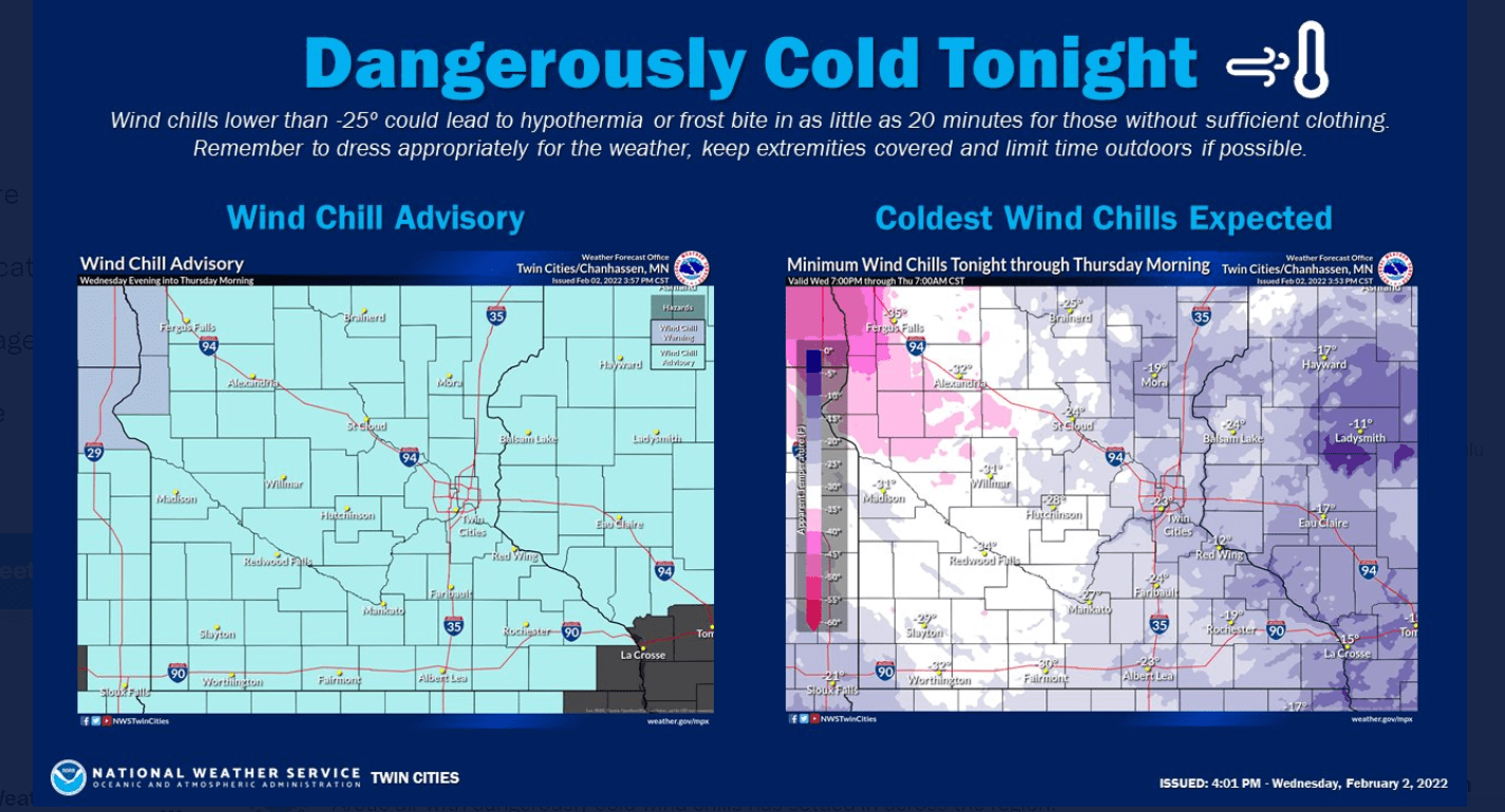
Wind chill advisories include the Twin Cities and southern Minnesota.
URGENT - WINTER WEATHER MESSAGE National Weather Service Twin Cities/Chanhassen MN 249 PM CST
Wed Feb 2 2022
...DANGEROUSLY COLD WIND CHILLS ACROSS THE ENTIRE COVERAGE AREA TONIGHT THROUGH THURSDAY MORNING...
Tonight through Thursday morning, lows will range from around 10 degrees below zero in far southern Minnesota and western Wisconsin to between 15 and 25 degrees below zero for much of central through southern Minnesota.
Combined with northwest winds of 5 to 10 mph, wind chills will drop to between 25 and 35 degrees below zero for all of central and southern Minnesota and western Wisconsin.
A Wind Chill Advisory is in effect this evening for much of west central through south central Minnesota. At midnight the advisory expands to encompass all of the coverage area. The advisory ends at 9 AM tomorrow for west central Wisconsin and east central Minnesota, and ends at noon tomorrow for the remainder of the coverage area.
Be sure to dress appropriately if venturing outdoors, including wearing layers, a hat and gloves. Be sure outdoor animals have ways of avoiding the dangerously cold wind chills and bring pets indoors.
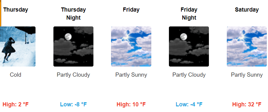
Temperatures rebound quickly for Saturday with highs into the 30s across southern Minnesota.
Turn Up Your Support
MPR News helps you turn down the noise and build shared understanding. Turn up your support for this public resource and keep trusted journalism accessible to all.

