Updraft® - Minnesota Weather News

Heavy, wet snow accumulates up north; nicer weekend ahead

Rain and snow showers for southern Minnesota.
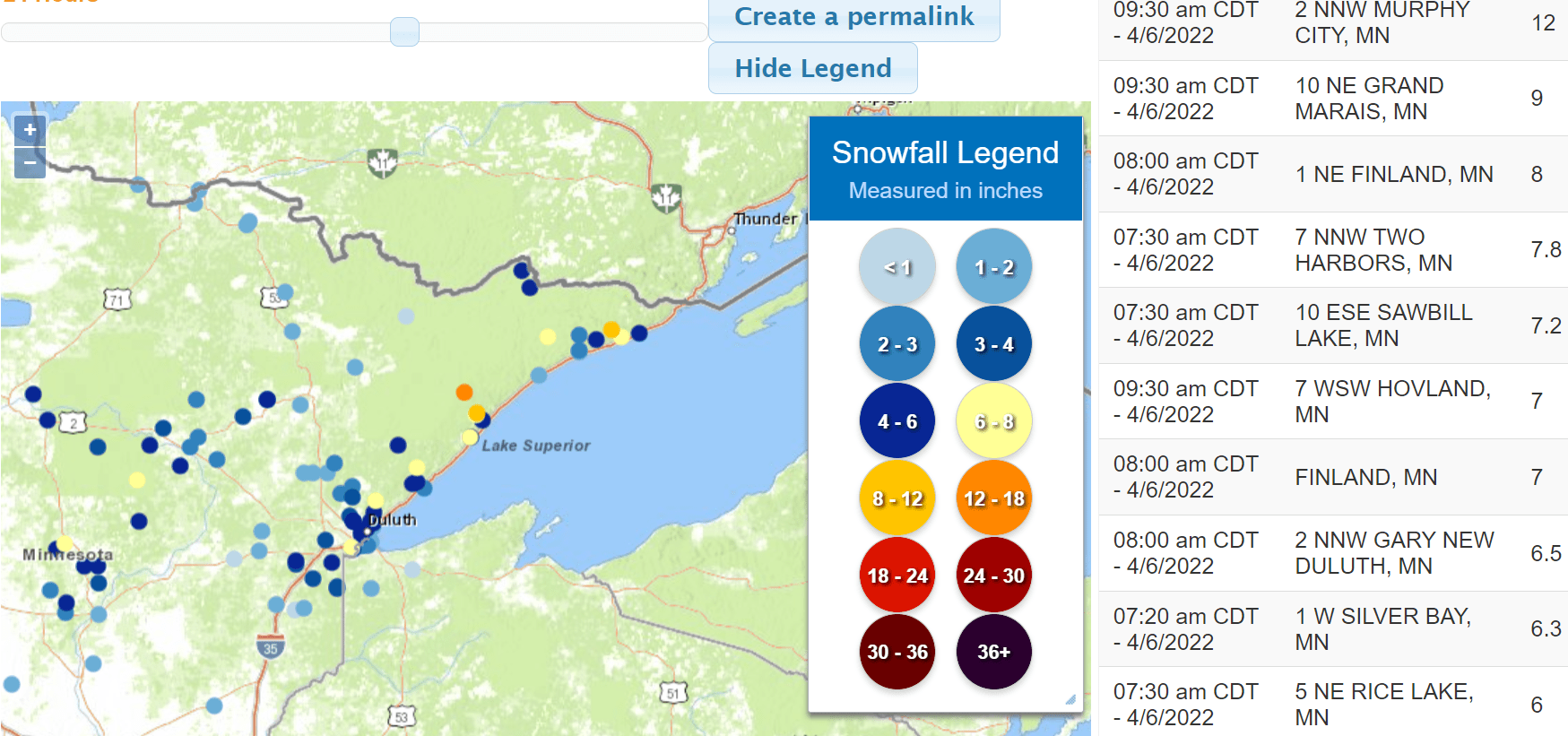
Snowfall reports
Snowfall reports.
Duluth National Weather Service

Welcome to another Wednesday wintry weather system in Minnesota.

A massive mid-latitude cyclone stretches more than 1,000 miles from Canada all the way to the Gulf Coast states. The National Oceanic and Atmospheric Administration’s GOES-16 visible satellite loop shows the classic comma shape spinning over the Upper Midwest.

This same storm produced 61 preliminary tornado reports in the Gulf Coast states Tuesday, according to NOAA’s Storm Prediction Center.

Storm reports
Storm reports Tuesday.
NOAA Storm Prediction Center

Wintry for Minnesota

Here at home, this system has produced widespread rain and plenty of snow up north.

The heaviest snowfall totals are coming in from northeast Minnesota on the higher terrain a few miles inland of Lake Superior. Warmer air near Lake Superior has reduced snowfall totals along the lakefront. The heaviest snow burst occurred overnight into early this morning.

Here are some selected snowfall totals as of midday.

  • Duluth area, 5 inches

  • Two Harbors, 2 to 5 inches (around town)

  • 7 miles NW of Two Harbors, 7.8 inches

  • Finland, 8 inches

  • 10 miles NE of Grand Marais, 9 inches

  • Murphy City,12 inches (on Highway 1 a few miles inland)

  • Chisholm, 4.4 inches

  • Bemidji, 4.8 inches

  • Two Inlets, 8.2 inches (Between Bemidji and Detroit lakes)

About an inch of snow is reported at many locations across central Minnesota, including just west and northwest of the Twin Cities.

Here at the Weather Lab in the southwest Twin Cities, I’ve recorded an inch of mostly rain with a few early morning snow showers.

Storm lingers

The heaviest snow with this system is behind us now. But snow showers will linger across much of Minnesota into Thursday and even early Friday. Here is a look at additional expected accumulations as of Wednesday morning for northeastern Minnesota.

Snowfall projection for northeast Minnesota
Snowfall projection for northeastern Minnesota.
Duluth National Weather Service

Wind advisories

Wind advisories cover most of western Minnesota. Gusts could reach 50 mph in western Minnesota. Gusts in the Twin Cities will exceed 30 mph.

Wind advisory
Wind advisory.
Twin Cities National Weather Service

Including the cities of Alexandria, Long Prairie, Morris, Glenwood, St Cloud, Madison, Benson, Montevideo, Willmar, Litchfield, Granite Falls, Olivia, Hutchinson, Gaylord, Redwood Falls, New Ulm, St Peter, St James, Mankato, Fairmont, and Blue Earth

935 AM CDT Wed Apr 6 2022

...WIND ADVISORY REMAINS IN EFFECT UNTIL 10 PM CDT THURSDAY...

* WHAT...Northwest winds 25 to 35 mph with gusts up to 50 mph expected.

* WHERE...Portions of central, south central, southwest and west central Minnesota.

* WHEN...From 7 AM this morning to 10 PM CDT Thursday.

* IMPACTS...Gusty winds could blow around unsecured objects. Tree limbs could be blown down and a few power outages may result.

Nicer weekend ahead

Our weather will finally improve after this slow-moving system pushes east by Saturday. Look for bright sun Saturday, with highs in the 50s in southern Minnesota this weekend.

Forecast high temperatures Sunday
Forecast high temperatures Sunday.
NOAA

There are signs of yet another midweek rain and snow system next week. There are also signs of highs in the 60s and possibly 70s around April 24-25.

Stay tuned.

Volume Button
Volume
Now Listening To Livestream
MPR News logo
On Air
BBC World Service: Newshour