
Scattered severe thunderstorms possible late Sunday afternoon into Sunday evening
Cooler and less humid on Monday
Go Deeper.
Create an account or log in to save stories.
Like this?
Thanks for liking this story! We have added it to a list of your favorite stories.


Areas of rain with a few embedded thunderstorms were over south-central Minnesota and parts of northwestern and north-central Minnesota at 11 a.m. Sunday, moving to the east-southeast.
A cool front will gradually work its way into Minnesota this afternoon and evening, and it’s expected to generate another batch of showers and thunderstorms. Those thunderstorms will tend to be mainly in northern Minnesota and parts of central Minnesota and northwestern Wisconsin during the early afternoon, then scattered thunderstorms will be possible anywhere in Minnesota and western Wisconsin later this afternoon into Sunday evening. The best chance of scattered t-storms in the Twin Cities metro area is expected to be very late this afternoon and into this evening.
Severe storms are possible
According to the NWS Storm Prediction Center, scattered severe thunderstorms are possible Sunday afternoon and evening in the yellow-shaded area of Minnesota (including the Twin Cities metro) plus parts of western Wisconsin:
Turn Up Your Support
MPR News helps you turn down the noise and build shared understanding. Turn up your support for this public resource and keep trusted journalism accessible to all.
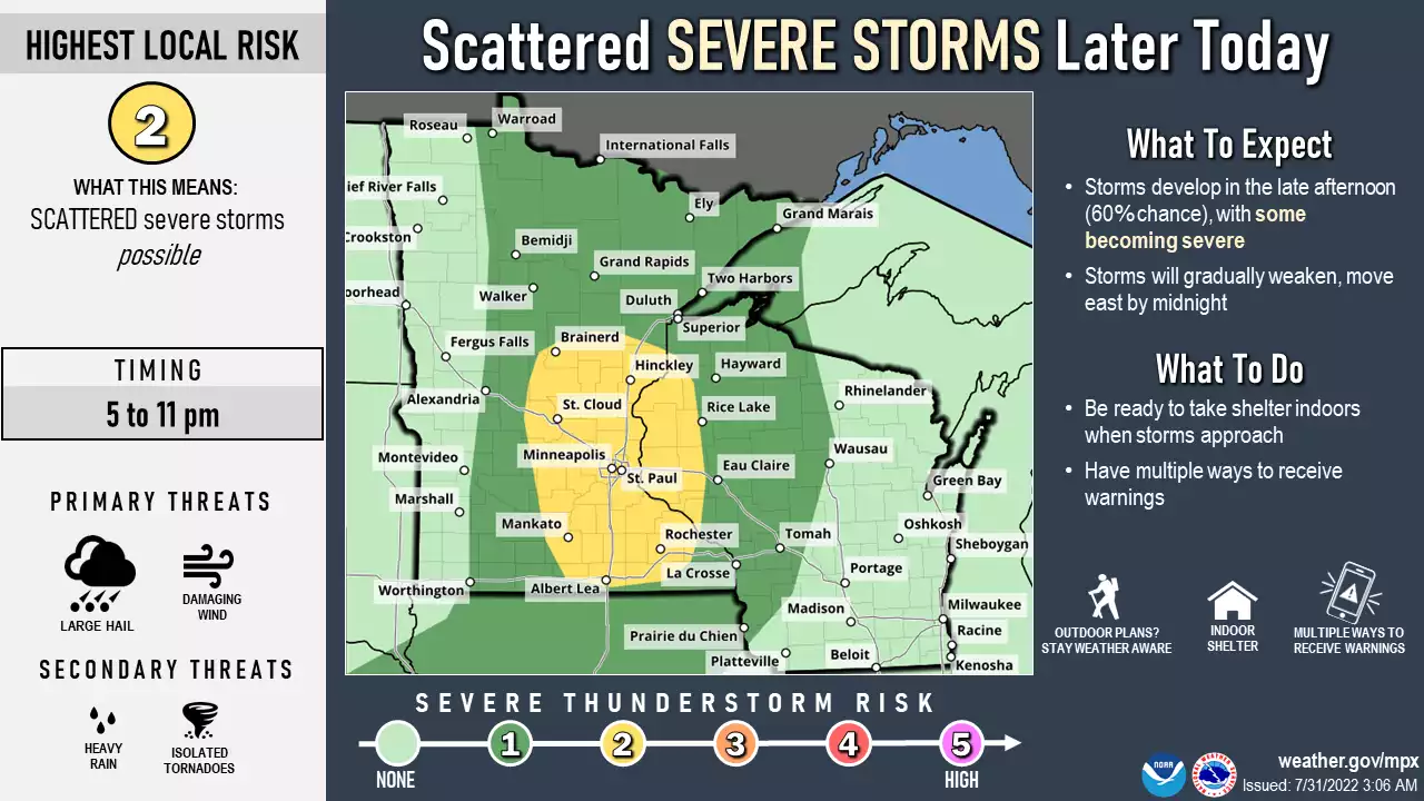
An isolated severe thunderstorm is possible in the dark-green shaded area. The graphic and its thunderstorm timing info are provided by the Twin Cities NWS office. The Storm Prediction Center updates the severe weather outlook every few hours.
Be weather-aware this afternoon and evening, and have a way to receive watches and warnings. It’ll be good to know what county you’re in, since weather warnings are issued by county or portions of counties.
You can hear updated weather information for Minnesota and western Wisconsin on the Minnesota Public Radio News network, and you can see updated weather info on the MPR News live weather blog.
Temps and dew points
Sunday highs will reach the lower 90s in southwestern Minnesota. We’ll see mainly 80s elsewhere, with mid to upper 80s in much of central Minnesota into the Twin Cities metro area and west-central Wisconsin. Far northern Minnesota could see a few 70s. Dew points will be in the sticky 60s in most areas.
Monday highs will retreat a few degrees in most locations:

Monday afternoon dew points will be in the comfortable 50s in much of northern and central Minnesota, with stickier 60s to the southeast:

Back to high temps, Twin Cities metro area highs are projected to reach the mid 90s on Tuesday then around 90 Wednesday, followed by mid 80s Thursday and lower 90s on Friday.
It looks like warm temps will linger next weekend into the beginning of the following week. The NWS Climate Prediction Center shows a strong tendency for above-normal temps in the upper Midwest from August 5 through August 9:

Weather nugget
Our Twin Cities record high for July 31 is 105 degrees, set in 1988. The Twin Cities high temp was 101 degrees the next day and 99 the day after that. The Twin Cities had 44 days with highs of 90 degrees or warmer in 1988. I was living in a house without air conditioning that year.

