MnDOT has closed many highways in southwest and south-central Minnesota, including a long stretch of I-90. Officials are advising no travel on highways across the rest of southern Minnesota
Many school districts and colleges have canceled or moved to e-learning Monday; the Minnesota House has canceled all committee meetings and is encouraging remote participation for its 3:30 p.m. floor session.
Secondary storm possible Tuesday night into Wednesday
Most highways in southern Minnesota that were closed due to blizzard conditions on Sunday night have now reopened.
The Minnesota Department of Transportation said those highways — which included Interstate 90 between Worthington and Albert Lea, and Interstate 35 from Albert Lea south into Iowa — reopened by 10 a.m. Monday.
However, no-travel advisories remained in place for that part of the state, amid ongoing hazardous driving conditions.
“If motorists need to travel, MnDOT urges drivers to use caution as roads are completely or partially covered with ice,” MnDOT reported just before 9:30 a.m. Monday. “Strong winds are expected to continue today causing blowing and drifting snow, icy and compacted roads, and difficult driving conditions.”
While highways were closed, the Freeborn County Sheriff’s Office said Sunday night that an emergency shelter for stranded travelers was opened at the National Guard Armory in Albert Lea.
Many schools across southern Minnesota canceled classes on Monday, or moved to online learning, amid the ongoing dangerous driving conditions.
Lake City mayor on Sunday's storm
by Cathy Wurzer
Lake City got 18.5 inches of snowfall at last report from the National Weather Service. Mayor Brian Quinn told Morning Edition the snow stuck to his window was heavy, wet and cementlike.
"The street plows actually had to use our heavy loader equipment to even start to clear the streets before the large plow trucks could even move the snow," he said. Crews there have been busy since around 4 a.m. Sunday.
During the course of the storm, a fire broke out at a pallet company that the mayor says employs about 50 people.
"We had to reroute our street plows to make a pass for the fire trucks to get back there," Quinn said. "A crew of seven people in a town that's about four and a half square miles, it really speaks a lot to their team collaboration and ability to communicate quickly, to pivot and get that route open so the crews could get back there."
Quinn said no one was hurt in the fire.
Armando Velasquez, 13, shovels snow with two of his friends in Rochester on Sunday.
Michael Ayres wasn’t surprised by the weekend blizzard walloping Rochester with 14 inches of snow by Sunday morning.
“Usual Minnesota,” said Ayres, 55, as he shoveled his walkway. “No surprises in March to have a big snow dump, and it’s fine.
“And [it] was very fortuitous. We had a sleepover at our house last night, so I had extra help this morning.”
The blizzard conditions made the city quiet except for the sound of a stray snow blower and the rush of gusting winds. As the snow started to peter out midday, residents began emerging from their homes.
Alton Ayres, 13, and his friends Armando Velasquez, 13, and Joseph Teng, 13, got roped into shoveling Sunday morning after a night of movies and games. But they’re hoping they can have fun later — maybe go sledding.
(From left to right) Joseph Teng, 13, Armando Velasquez, 13, and Alton Ayres, 13, help shovel snow after a sleepover Sunday.
Molly Castle Work | MPR News
Southeast Minnesota was hit particularly hard by the weekend snowstorm. Rochester and nearby cities like Mankato suspended public transportation operations Sunday and urged residents to stay at home and off roadways if at all possible. Highways closed across the region, even down to Iowa.
But, that meant Rochester residents got creative, taking other modes of transportation Sunday.
Lonny Olson-Williams, 64, skied down a snow-covered sidewalk in his neighborhood, heading towards a bike path that weaves alongside the Zumbro River.
“I make a point of trying to enjoy the snow when it shows up,” Olson-Williams said. “Electricity is on. Water is running. It’s a good day.”
Lonny Olson-Williams, 64, skis in Rochester on Sunday.
Molly Castle Work | MPR News
Further up the block, several neighbors ran snowblowers and shoveled, working together to clear paths. More snow was forecast to fall later on. But there was a consensus — everyone was happy the state was getting a good old-fashioned snowstorm after a few years of mild winters.
“The past three winters have been super just… bleh… ’wussy,’ I call it,” said Carrie Nelson, 54. “It's nice to actually see a decent snowfall.”
Around the corner, Adam Carlson, 44, was running his snowblower, clearing the sidewalk along his entire block. He said the same thing and also explained how he enjoys the fringe benefits of a weekend snow day.
“It’s just a nice way to kind of slow down,” Carlson said. “Nobody expects things to really move, you know. So it’s kind of a nice excuse to get the snow cleaned and just warm up, have a nice cup of coffee or tea and make a stew and chill out.”
Adam Carlson, 44, uses his snowblower machine to clear walkways Sunday in Rochester.
Molly Castle Work | MPR News
St. Paul gets less snow than anticipated
Mark Dahl, 56, has his shoveling routine down so well he doesn’t even wear a coat knowing he’ll work up a sweat, especially with how heavy the late-season snow can be.
He still hacked away at the snow that was as tall as the top of his boot in layers, first using his snow thrower — which is like a small version of a snowblower — and then a shovel, to make the heart-attack snow more manageable.
He lives in St. Paul’s Highland Park neighborhood, which like most of the rest of the Twin Cities, is under a snow emergency. That means cars needed moving by Sunday night, lest they end up trapped by snowdrifts from plowing, or towed. Even if they wanted to go anywhere, officials all over the state warned travel was dangerous.
“Most of the cars will be out,” Dahl said. “I don’t know, these people hardly ever move their car anyway, so they just go right around them and pin them in.”
Just a block over, Tyler Wied cleared his sidewalk, a rude awakening after flying back from the 95-degree Costa Rican sunshine.
A neighborhood in the Highland Park area of St. Paul was quiet at 7:20 a.m. as more snow falls on Sunday.
Anika Besst | MPR News
He and his wife moved their flight up to get ahead of the more than 700 cancellations at Minneapolis-St. Paul International Airport during the blizzard.
“The flight coming from Costa Rica today was canceled, so we made the right decision to come back on Saturday,” he said Sunday.
A few houses down, Stella Dinzeo admitted it could have been worse, especially since the temperature wasn’t Arctic.
“It’s really heavy, but it’s not bad,” she said. “It’s refreshing and not as bad as I expected. I was prepared for, you know, Minnesota to blow up, according to the news. It sounded worse than what it is.”
Down the street, Gretchen and Jim Guenter took their dogs Jasper and Kayla for a walk, much to the dogs’ excitement. They’re medium-sized cattle dogs that beamed, with tails flying.
“Our younger dog, Jasper, he just gets the zoomies,” Gretchen said. “He just wants to go in every fresh piece of snow there is, up on every lawn, through every pile.”
After days of 50-degree weather the past few weeks, deep down, they knew Minnesota was in for another blast, though for the Twin Cities it was milder than the 18 to 24 inches originally predicted. But it was still enough to prompt St. Paul to cancel school Monday.
“It feels weird, but it is March and it is tournament season. So this is what we get every year, right?” Jim said.
Ronan Falenczykowski, 10, plays in a snow fort at Victory Park in North Minneapolis during a snowstorm on Sunday.
Snowfall continues across southern Minnesota as a weekend winter storm moves through the state. For some Minnesotans, it was a welcomed day to play in the snow and for others … it was a lot of shoveling.
Our freelance photographers in the Twin Cities and Rochester followed along
Twin Cities
9 of 9
Anja Nord, 2, rides a sled pulled by her mom, Addie, as they walk home from the park along North 44th Avenue in Minneapolis during a snowstorm on Sunday.
Carly Danek for MPR News
1 of 9
David Policard laughs as he sleds away from his family at the Theodore Wirth Sledding Hill in Minneapolis during a snowstorm on Sunday.
Carly Danek for MPR News
2 of 9
Alexis Bravo (in yellow), 10, rides the shoulders of his brother, Fernando, 13, as their family looks on at Theodore Wirth Sledding Hill in Minneapolis during a snowstorm on Sunday.
Carly Danek for MPR News
Rochester
5 of 5
Snowplows begin to clear downtown roads on Sunday in Rochester.
Marissa Ding for MPR News
1 of 5
Arlen Unger shovels chunks of densely packed snow and ice from underneath his truck on Sunday in Rochester.
Marissa Ding for MPR News
2 of 5
A snowplow backs up while preparing to clear more snow on Sunday in Rochester.
Marissa Ding for MPR News
A Minneapolis Public Works snowplow clears snow along Nicollet Avenue during heavy snowfall on Sunday.
Minnesota transportation officials closed highways in south-central Minnesota on Sunday evening — including a long stretch of Interstate 90 — with blizzard conditions expected to continue into early Monday.
“Snow and strong winds are creating blowing and drifting snow, significantly reducing visibility and creating hazardous travel conditions,” the Minnesota Department of Transportation reported. Those conditions could become even more hazardous after nightfall.
MnDOT said the closures include:
I-90 between Worthington and Albert Lea
State Highway 60 between Mankato and the Iowa border
State Highway 19 between Winthrop and the Iowa border
U.S. Highway 169 between Vernon Center and the Iowa border
All other state and federal highways in Nobles, Jackson, Cottonwood, Watonwan, Martin and Faribault counties
Those closures are expected to remain in place overnight, and until conditions improve on Monday. Find updated information on MnDOT’s 511 website.
While the heaviest snow has already fallen, blizzard conditions will continue into Sunday night as powerful winds blow around the fresh snowpack. Snowfall is expected to finally wrap up late tonight.
Blizzard conditions continue; chilly start to the work week
Snowfall totals continue to stack up across southern Minnesota and western Wisconsin as this powerful weekend winter storm moves through the region.
Snowfall amounts
National Weather Service
The hardest-hit area from the storm has fallen roughly 50 to 75 miles south and east of the Twin Cities, stretching from near Rochester through the Mississippi River Valley and into western Wisconsin. Many communities have already exceeded 12 inches of snow, with some locations reporting totals just shy of 2 feet.
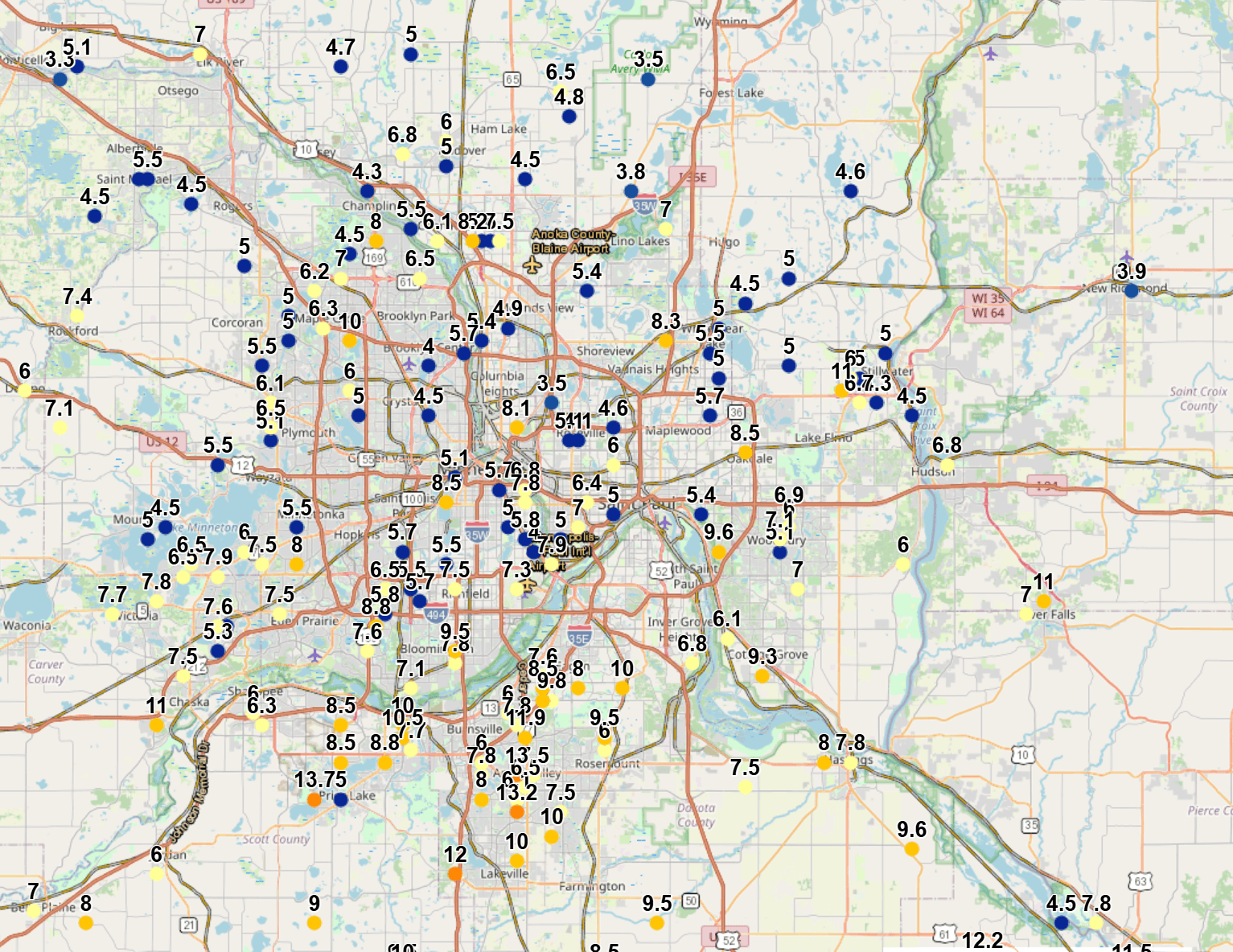
Snowfall in the Twin Cities metro varied, with the south metro receiving 10 to 12 inches, while the north metro saw 4 to 8 inches.
Metro area snowfall
National Weather Service
The shift to the south occurred because the storm’s surface low pressure system tracked farther south than originally expected. Rather than moving from near Des Moines toward Milwaukee, the system is now following a path from Kansas City toward the north side of Chicago.
Winter weather advisories will remain in effect for west-central and central Minnesota until 1 a.m. Monday. Portions of the Twin Cities metro have been downgraded to a winter storm warning until 1 a.m., while a blizzard warning remains in effect until 4 a.m. Monday for areas south of the Minnesota River Valley, including parts of the south metro and southern Minnesota. Additional snow of 1 to 3 inches is possible, along with gusty northwest winds of 40 to 50 mph.
Winter hazards
National Weather Service
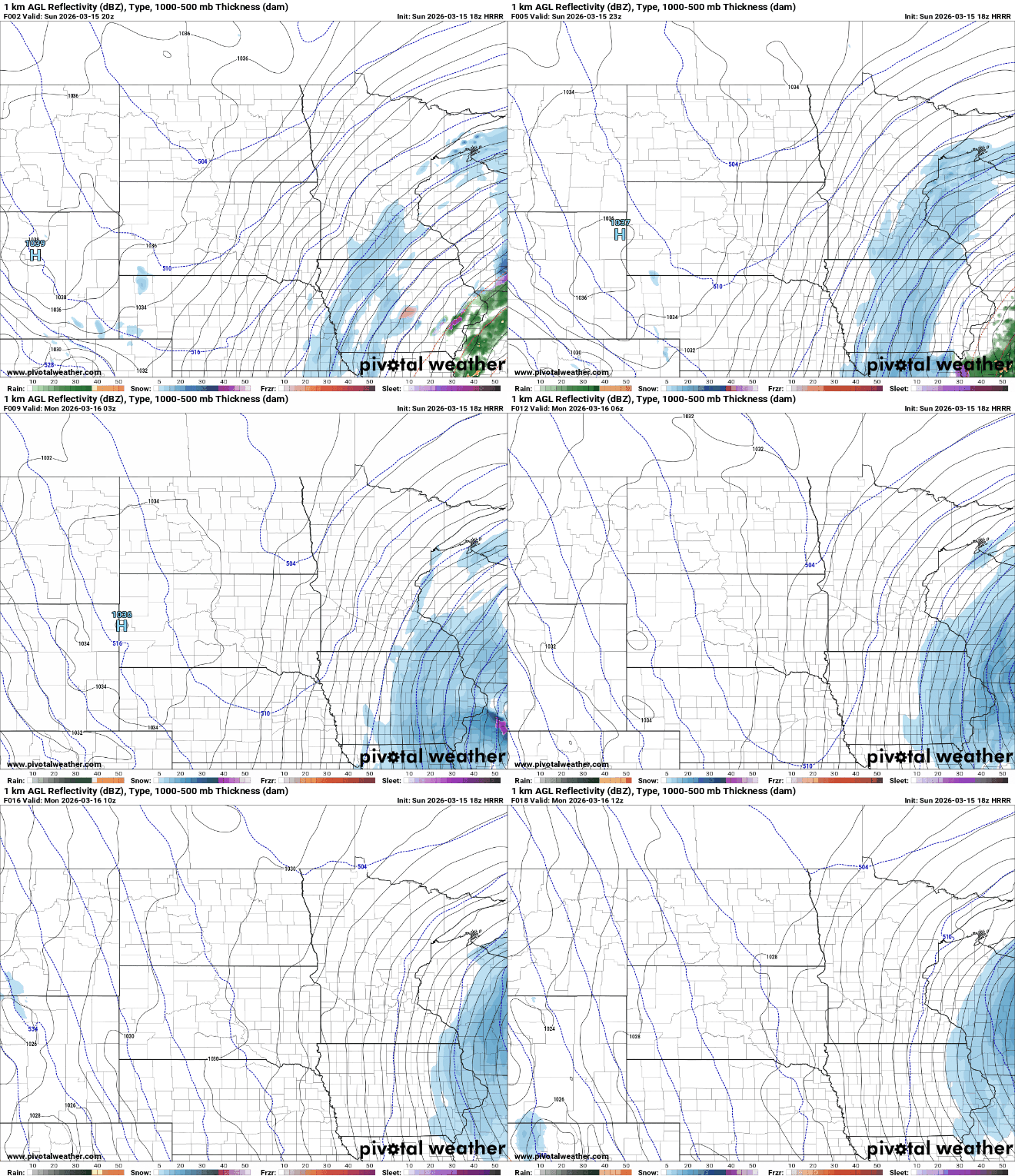
Snowfall is expected to taper off from west to east late Sunday afternoon into Sunday evening, but gusty north-northwest winds will continue to create low visibility and icy roads as snow blows and drifts.
Forecast precipitation Sunday 3 p.m. to Monday 7 a.m.
NOAA via Pivotal Weather
Chilly start to the work week
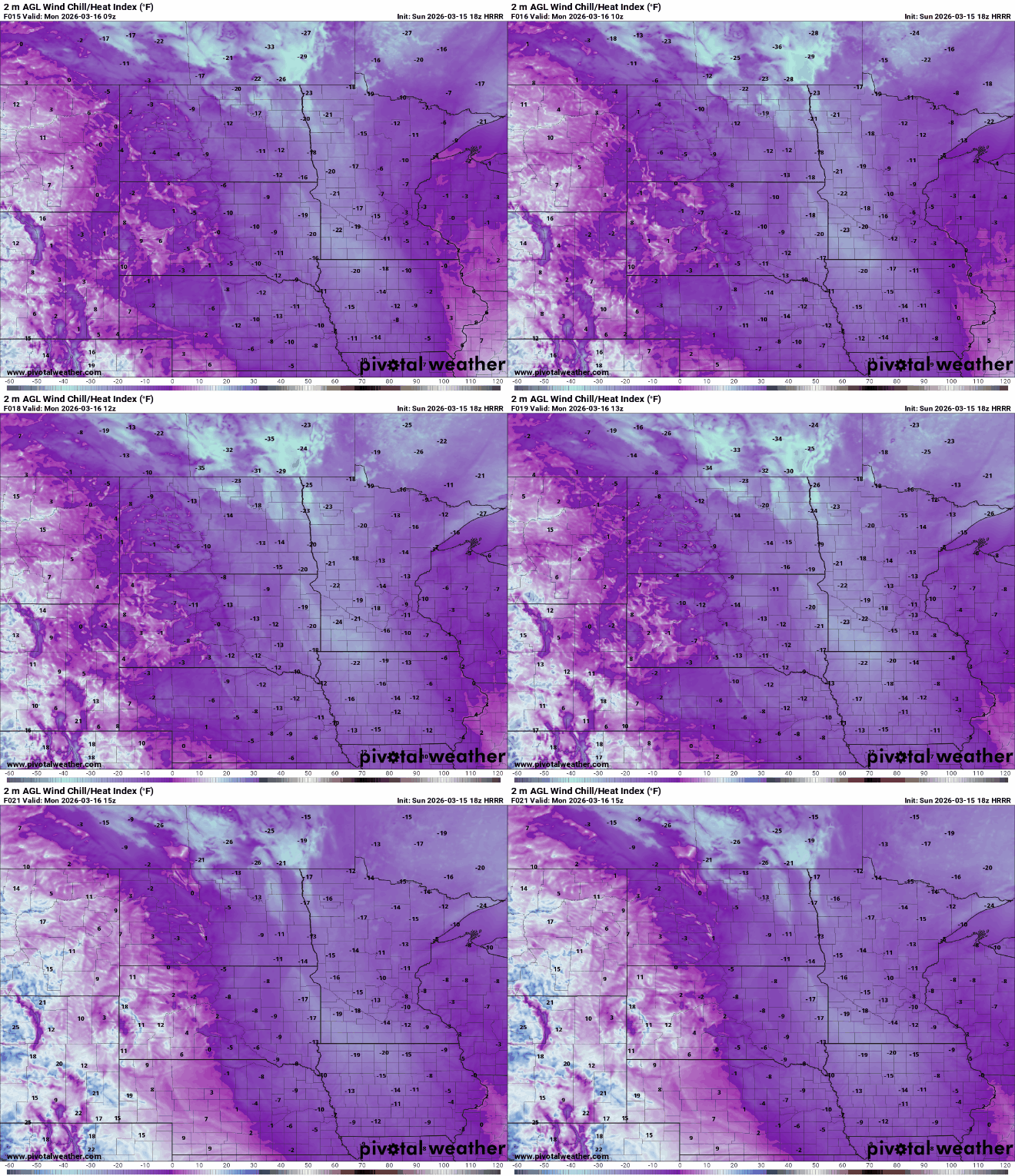
Forecast temperatures for Sunday night will feel more like mid-January than mid-March. Readings are expected to drop into the single digits above and below zero, with gusty northwest winds keeping wind chills in the teens and 20s below zero.
Lows for Sunday night
National Weather Service
Wind chill forecast Monday 4 a.m. to 10 a.m.
NOAA via Pivotal Weather
A quick-moving system is expected Tuesday evening, bringing a brief 1 to 2 inches of snow. Behind this system, a warm-up is forecasted, which will lead to significant snowmelt across the region later this week.
Beth Detuncq helps clear her neighbor's driveway in the alley between North Sheridan and Thomas Avenues in Minneapolis during a snowstorm on Sunday.
Blizzard conditions across much of Minnesota and neighboring states on Sunday are forecast to continue overnight — which could mean another day of difficult travel conditions on Monday.
Because of that, some school districts and colleges have announced plans to delay or cancel classes — or move to online learning — on Monday. Minneapolis, St. Paul and Rochester are among the districts changing plans. Find a complete list below.
In addition, the Minnesota House announced that all committee meetings scheduled for Monday are canceled. The House is still planning a 3:30 p.m. floor session on Monday, “with remote participation encouraged for members unable to arrive safely.”
College and university changes for Monday, March 16
Closed
Dakota County Technical College
Inver Hills Community College
Minnesota State College Southeast — Red Wing and Winona campuses
Riverland Community College — all campuses
Moved to e-learning day
Minnesota State University Mankato
Mitchell Hamline School of Law
South Central College — Faribault and North Mankato campuses
Delayed start
Minnesota West Community & Technical College — all campuses opening at noon
Southwest Minnesota State — campus opens at 10 a.m.
A truck is stuck in the median amid heavy snow as traffic passes by along Interstate 35 north of the Ellendale exit in southern Minnesota on Sunday morning.
MnDOT continued to advise no travel across southern Minnesota as of late Sunday morning.
“Snowplows are having difficulty in current conditions but remain on the roads at this time. Current rates of snow are covering roads faster than snowplows can clear a driving lane,” MnDOT’s District 6, covering southeast Minnesota, reported as of 10 a.m.
To the north along I-35, officials in Steele County — which includes Owatonna — issued an alert advising no travel on all roads.
“Non-essential personnel should STAY OFF ROADS within Steele County to ensure your safety. Current road conditions pose significant risks to drivers and pedestrians,” county officials reported just after 10 a.m.
Rochester and Mankato have announced that public transit is ending all service Sunday due to blizzard-like conditions that could make travel dangerous.
Both cities said they expect to start service again Monday morning, but they warned of delays and potential blocked roadways.
Rochester received 13 inches of snowfall as of 10 a.m. Sunday, according to the National Weather Service. Mankato has received 6 inches.
The cities as well as the Minnesota Department of Transportation urged residents this morning to stay home and remain off the roads if at all possible today.
A neighborhood in the Highland Park area of St. Paul was quiet at 7:20 a.m. as more snow falls on Sunday.
With more snow coming throughout Sunday, warming centers are available to keep people dry who may be unhoused. Find a list below.
Ramsey County
Union Gospel Mission: People can stay dry there all day. There is a warming center overnight 9 p.m. to 6:30 a.m. Their address is 435 University Ave E, St. Paul, MN 55130.
Central Presbyterian Church: Open every night from 9 p.m. to 7 a.m., for youth and families. Their address is 500 Cedar St, St. Paul, MN 55101.
The Holy Christian Church International: Open every night from 9 p.m. to 7 a.m., for men and women. Their address is 125 Stevens St West, St. Paul, MN 55107.
Hennepin County
Hope Avenue Twin Cities: Open every day from 7 a.m. to 3 p.m. Their address is 1229 Logan Ave, Minneapolis, MN 55411.
Minnesota Indian Women’s Resource Center: Open all day Sunday and overnight to Monday for a warming center. At 9 a.m., they have breakfast. Their address is 2300 15th Ave S., Minneapolis, MN 55404.
Hennepin County Libraries: The locations below are open from 12-5 p.m. More locations are open on Monday.
Augsburg Park Library: 7100 Nicollet Ave, Richfield, MN 55423
Brookdale Library: 6125 Shingle Creek Pkwy, Brooklyn Center, MN 55430
Brooklyn Park Library: 8500 West Broadway Ave, Brooklyn Park, MN 55445
East Lake Library: 2727 East Lake St, Minneapolis, MN 55406
Eden Prairie Library: 565 Prairie Center Dr, Eden Prairie, MN 55344
Edina Library: 5280 Grandview Square, Edina, MN 55436
Franklin Library: 1314 East Franklin Ave, Minneapolis, MN 55404
Golden Valley Library: 830 Winnetka Ave, North Golden Valley, MN 55427
You can call the Hennepin Shelter Hotline at 612-204-8200 to reserve a bed. During severe cold temperatures, additional shelter beds are made available.
Blizzard conditions continue to develop across central and southern Minnesota as a powerful late-season storm produces intense snowfall rates and powerful wind gusts approaching 60 mph, creating dangerous travel conditions.
Blizzard conditions develop amid heavy snow and hazardous travel
Our powerful late-season snowstorm continues to hammer the southern half of Minnesota this morning. Early snowfall reports are already showing just how intense these snow bands have been. Rochester has reported 11 inches of snow, while Mankato and Owatonna have picked up around 9 inches. Closer to the Twin Cities, the southern metro has already seen totals near 10 inches, with more snow still falling.
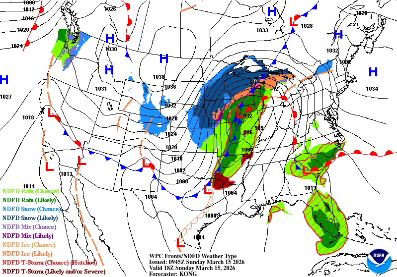
The center of the storm system early Sunday morning is located over central Kansas and is tracking northeast toward eastern Iowa. As the system strengthens and tilts, the northwestern side of the storm, which is typically the heaviest snow region, will sit directly over southern Minnesota and western Wisconsin.
Surface analysis for Sunday 1 p.m.
NOAA via Weather Prediction Center
As the system moves east, it will continue to intensify and bring very gusty winds of 50-60 mph, creating blizzard conditions across southern Minnesota. These increasing winds will lead to widespread blowing and drifting snow, significantly reducing visibility and making travel extremely dangerous. Blizzard warnings remain in effect for the southern half of the state through Monday morning.
Winter hazards Sunday and Monday.
NOAA via Pivotal Weather
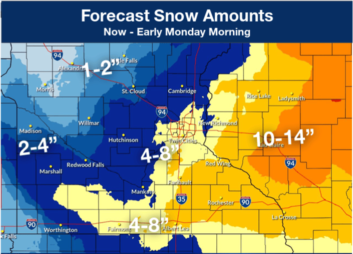
Snow will continue to fall through the day, bringing another 4-8 inches to the Twin Cities and communities along Interstate 90. Meanwhile, southeastern Minnesota and western Wisconsin are positioned under the storm’s most intense snow band, where an additional 10-12 inches or more is possible.
Additional snowfall potential.
National Weather Service
The heaviest snow will ease up Sunday afternoon, but strong winds will continue to blow snow around into Monday, leading to a messy and slow Monday morning commute.
Snowfall timing
National Weather Service
Arctic air follows the storm
Temperatures on Sunday will stay in the 20s and 30s before a brief burst of Arctic air moves in at the start of the workweek.
Highs for Sunday.
National Weather Service
Lows Sunday night are expected to drop into the single digits, both above and below zero.
Lows for Sunday night.
National Weather Service
With winds still gusting around 30–40 mph, wind chills Monday morning could make it feel like the teens and 20s below zero.
Wind chill forecast for Monday morning.
National Weather Service
A smaller system is expected to move in Tuesday evening into early Wednesday, bringing the potential for a few additional inches of snow. Once that system passes, temperatures will warm up significantly, with highs climbing back above freezing.
Kim Detuncq uses a broom to clear her car in the alley behind North Thomas Avenue in Minneapolis during a snowstorm on Sunday.
Authorities advised no travel across southern Minnesota on Sunday, as blizzard warnings remained in effect for the region through early Monday.
As of Sunday afternoon, the National Weather Service had received reports of 8 to 12 inches of snow from Waseca and Lonsdale north to the southern and eastern Twin Cities metro area, with snow still falling.
There were reports of around a foot of snow in the Rochester area, and 14 to 20 inches in a band from Pine Island and Oronoco to Millville to Lake City and Kellogg.
In an update just after 9 a.m., the public works department in Lake City — where weather spotters reported 17 inches of snow — said crews “are actively deployed and doing everything they can to keep streets open and respond to the storm. However, the combination of deep, heavy snow and strong winds is making snow removal extremely challenging, and drifting is quickly covering areas that have already been cleared.”
The city was asking people to stay off the roads “unless travel is absolutely necessary.”
Snow is forecast to gradually taper off through the day Sunday, but increasingly gusty winds will cause blowing and drifting snow, and reduced visibilities.
No travel advised
As of 4:45 p.m. Sunday, the Minnesota Department of Transportation continued to advise no travel on highways from near Worthington, Pipestone and Marshall, east to Mankato, Blue Earth, Faribault, Owatonna, Albert Lea, Rochester, Wabasha and Winona.
That included long stretches of Interstates 35 and 90.
“Blowing snow and strong winds are creating blizzard conditions and are making travel difficult,” officials with MnDOT’s District 7 in south-central Minnesota reported early Sunday. “Conditions are expected to remain difficult today until they gradually improve on Monday.”
“Blue Earth County road crews are out today, but that doesn’t mean it’s safe to travel,” the Blue Earth County Sheriff’s Office in Mankato reported Sunday morning.
MnDOT closed southbound Interstate 35 south of Albert Lea by on Sunday afternoon, because officials in Iowa closed their portion of the freeway amid the blizzard conditions. Iowa transportation officials said I-35 is closed between the Minnesota state line and Ames until conditions improve.
MnDOT reported snow-covered highways across the rest of the southern two-thirds of the state, including freeways in the Twin Cities metro area. Authorities responded to a steady stream of crashes and spinouts through the morning and into the afternoon.
Snelling Avenue in Highland Park remains quiet Sunday morning after a snowstorm buried the Twin Cities overnight, with snow continuing to fall.
Anika Besst | MPR News
Snow emergency parking rules are in effect in Minneapolis, St. Paul and some other communities across the state.
The Minnesota State Patrol reported more than 250 crashes and spinouts across the state from midnight through 10 p.m. Saturday, as the snow started to fall.
From midnight through 1 p.m. Sunday, the Patrol reported more than 375 additional crashes and spinouts. Those numbers are only for state and federal highways; they don’t include city and county roads.
Highways closed in Wisconsin, South Dakota
To the east — Wisconsin transportation officials on Sunday morning advised no travel in the northwest quarter of the state “as all highways are partially or completely covered with snow or impassable, and more snow is expected throughout the day.” That advisory was later expanded to cover most of the northern two-thirds of the state.
As of 10 a.m., officials said all lanes of Interstate 94 in Jackson County, Wis., were blocked “and many alternate routes around the interstate are impassable. Heavy snow, blowing winds and poor visibility have made it difficult for snowplows to keep up, and some counties are pulling plows from secondary routes.”
To the west — South Dakota transportation officials closed highways across much of the state late Saturday “due to the combination of heavy snow and sustained strong winds causing snow-covered roads, blocked bridges and underpasses, and greatly reduced visibilities.”
Interstates 29 and 90 reopened by late Sunday morning, but officials said “extremely difficult driving conditions are expected today due to blowing snow and poor visibility.”
Twin Cities transit
Metro Transit buses and trains are operating in the Twin Cities amid the storm.
Throughout Sunday morning, Metro Transit reported about a quarter to half of bus routes were behind schedule, but only by an average of about 5 to 10 minutes. Officials said “significant delays” are expected through the day.
Metro Transit said Blue Line light rail trains were also experiencing some delays.
If you’re planning to fly from Minneapolis-St. Paul International Airport or another airport around the region — or if you are expecting visitors to arrive by plane — airports offer flight status updates online:
Minneapolis Mayor Jacob Frey and St. Paul Mayor Kaohly Her announced snow emergencies in their respective cities on Saturday at a press conference at the St. Paul Public Works Dale Street Garage.
Mayors Jacob Frey of Minneapolis and Kaohly Her of St. Paul announced snow emergencies for their respective cities starting Sunday night ahead of possibly historic blizzard conditions.
The National Weather Service expects up to 18 inches of snow overnight in the Twin Cities, with up to two inches of snow falling per hour starting Saturday night. Parking restrictions for emergency plowing go into effect for both cities beginning 9 p.m. Sunday.
“This may be a very significant snow and I can tell you that our snowplow drivers are in the starting blocks and they're ready to go,” Frey said Saturday afternoon at the joint press conference in St. Paul. “For them, this is the Super Bowl.”
Her asked St. Paul residents to plan ahead to ensure snowplows operate efficiently.
“Moving now will help you avoid becoming stuck in a snow bank, and will give our crews room to work and make sure you have safe roads to drive on when the time comes,” Her said.
Sean Kershaw, the St. Paul public works director, warned the snow will be “wet and tall” and will freeze in the cold temperatures forecast for Monday.
“Do yourself a favor. Do your neighbors a favor,” Kershaw said. “Because you don't want to be the car that has 18 inches of snow plowed up around you, because you're going to be there for a few days.”
Officials from both cities said vehicles in violation could face tickets or a tow bill if parked illegally.
Both cities are offering free parking to clear the streets.
Free parking is available in St. Paul starting at 5 p.m. Saturday until 5 p.m. Monday at the Block 19 ramp downtown. Some Parks and Recreation lots will also be available once cleared; officials advise looking to stpaul.gov/snow for updates on locations.
Minneapolis is offering more than 700 free spots downtown at the Farmer’s Market and Salvation Army parking lots from 2 p.m. Saturday until 8 p.m. Wednesday.
For $1, people can also park at the Ramp A parking lot in downtown Minneapolis from 6 a.m. Sunday until 8 p.m. Wednesday.
Minneapolis will prioritize main roads on Sunday before the snow emergency. Residential street plowing will begin Monday and Tuesday.
St. Paul will continuously plow main streets starting Saturday through Sunday as the snow falls before the emergency declaration takes effect. Night plow routes begin 9 p.m. Sunday, transitioning to day plow routes Monday.
In St. Paul, garbage and recycling will not be picked up Monday. Kershaw instructed residents to put their bins on the boulevard instead of the street on Tuesday.
Minneapolis garbage collection will continue on schedule.
St. Paul residents can report fallen tree branches via email. Officials asked residents to hold off on calling until Tuesday morning.
Gov. Tim Walz declared a peacetime emergency and activated the Minnesota National Guard to help respond to possible fallout from the impending winter storm.
Walz said in his Friday evening executive order Steele County had already requested help from the state. Walz said local and county governments did not have the resources to respond without assistance from the state.
The National Weather Service is predicting up to two feet of heavy snow in parts of the state, including the Twin Cities, which could cause infrastructure damage or injuries.
Minnesota could be in for a large March snow storm this weekend. A strong system is heading toward the region for March 14 and 15 and there’s increasing potential for some pretty heavy snowfall. Much of southern and eastern Minnesota and western Wisconsin could see 12 to 18 inches of snow, with possible isolated totals of over 20 inches.
MPR News’ meteorologists are tracking the system to bring you the latest forecast.
Traffic moves along State Highway 61 amid snowy conditions on the North Shore near Schroeder, Minn., on Friday.
The first round of a one-two punch of winter storms in Minnesota dropped more than a foot of snow on parts of the North Shore from Thursday into Friday.
As of midday Friday, the top snow total was 14 inches at Hovland in Cook County. Hovland also received more than 40 inches of snow in a winter storm last month.
Other totals reported to the National Weather Service from the Thursday-Friday blizzard are listed below.
Central and southern Minnesota are in line to see heavy snow from the next winter storm, forecast to arrive over the coming weekend.
March 12-13 snow totals
14 inches — Hovland
12.6 inches — Grand Marais
12 inches — Silver Bay
11 inches — Fond du Lac, Esko
10.3 inches — Hackensack
10 inches — Two Harbors
9.6 inches — Mahtowa
9.5 inches — Duluth (Lester Park)
9.3 inches — Duluth airport
9 inches — French River, Barnum, Duquette
8.8 inches — Holyoke
8.7 inches — Lutsen
8.5 inches — Sawbill Lake, Tower
8.3 inches — Brimson
8.2 inches — Poplar Lake
8 inches — Wales, Knife River, Kerrick, Tamarack
7.9 inches — Fredenberg
7.5 inches — Makinen, Payne, Park Rapids
7.4 inches — Chisholm
7.2 inches — Grand Rapids, Libby
7 inches — International Falls, Cook, Embarrass
6.8 inches — Finland, Coleraine
6.5 inches — Hibbing, Sturgeon Lake, Bena
6.2 inches — Cloquet
6.1 inches — Wright
6 inches — Bovey, Blackberry, Hoyt Lakes, Biwabik, Celina, Nevis
Snow and gusty winds combine to create blizzard conditions along State Highway 11 in Kittson County in northwest Minnesota, near Donaldson, on Friday, Jan. 17, 2025. This view is from a MnDOT traffic camera.
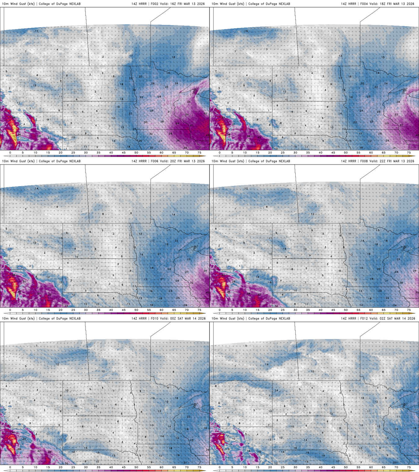
A powerful burst of overnight winds swept across the state Thursday night into Friday, with numerous locations reporting gusts over 60 mph and a few approaching the mid-70 mph range.
One of the strongest wind gusts reported was near Hector in Renville County at 74 mph. Other locations also experienced extremely strong winds. Canby recorded a 73 mph gust and Springfield measured 72 mph.
Several additional sites reported gusts above 65 mph, including:
Blue Earth — 71 mph
Dawson — 71 mph
Redwood Falls Airport — 71 mph
Benson Airport — 70 mph
Morris Airport — 68 mph
Clara City — 68 mph
Across the Twin Cities metro, the winds were also intense. Minneapolis-St. Paul International Airport reported a gust of 61 mph, while Crystal reached 64 mph and Eden Prairie reported a gust of 63 mph.
Winds will gradually ease later Friday, but gusty conditions are likely to continue through much of the afternoon.
Wind speed and direction for Friday 11 a.m. to 9 p.m.
Heavy snow fell across northern Minnesota Thursday night into early Friday. Freelance photojournalist Erica Dischino captured these images for MPR News.
13 of 13
Snow removal is underway Friday, March 13, 2026 in downtown Duluth, Minn. A winter storm warning is in effect along the North Shore.
Erica Dischino for MPR News
1 of 13
Shoveling snow began before the sun rose Friday, March 13, 2026 in Duluth, Minn. A winter storm warning is in effect along the North Shore.
Erica Dischino for MPR News
2 of 13
A skeleton with a Santa hat is buried in snow seen Friday, March 13, 2026 in Duluth, Minn. A winter storm warning is in effect along the North Shore.
Erica Dischino for MPR News
Lake Superior waves crash to the shore as a pedestrian walks along the Lakewalk Friday, March 13, 2026, near Canal Park in Duluth, Minn. A winter storm warning is in effect along the North Shore.
The first part of March started off warmer than usual with places like Pipestone and Worthington in southwestern Minnesota reaching 70 degrees.
“But now we're going to go the other way,” says climatologist and meteorologist Mark Seeley.
Temperatures are expected to dive to between 15 to 20 degrees below normal starting Sunday and lasting through Tuesday. Seeley said it’s often typical for the month of March to have such a range of highs and lows.
Seeley said he expects the Twin Cities will pick up a month’s worth of snowfall over the weekend, with at least 7 to 9 inches.
Listen to the full conversation by clicking the player above.
A snowplow clears Interstate 35E in Mendota Heights amid a winter storm on Dec. 28, 2025.
Wind gusts up to 70 mph swept across the southern half of Minnesota and caused power outages early Friday ahead of a another major storm this weekend.
Wet, heavy snow is forecast to start late Saturday in central and southern Minnesota.
Mike Griesinger, a forecaster at the National Weather Service in the Twin Cities, said anyone in the region with Sunday travel plans should try to reschedule.
“During the heart of the storm late Saturday night into Sunday morning we’ll likely have snowfall rates at 2 to 3 inches per hour, and there's not a snowplow in Minnesota that can keep up with that,” he said Friday morning.
Much of southern Minnesota can expect at least 6 inches of snow this weekend. The Weather Service says a band of up to 2 feet will likely hit somewhere between the Twin Cities and Rochester.
Griesinger said winds will diminish later Friday before picking up again later Saturday as the weekend storm approaches.
The Weather Service said blizzard conditions are possible in southern Minnesota at the peak of the storm on Sunday.
News you can use in your inbox
When it comes to staying informed in Minnesota, our newsletters overdeliver. Sign-up now for headlines, breaking news, hometown stories, weather and much more. Delivered weekday mornings.