MnDOT has closed many highways in southwest and south-central Minnesota, including a long stretch of I-90. Officials are advising no travel on highways across the rest of southern Minnesota
Many school districts and colleges have canceled or moved to e-learning Monday; the Minnesota House has canceled all committee meetings and is encouraging remote participation for its 3:30 p.m. floor session.
Secondary storm possible Tuesday night into Wednesday
Authorities advised no travel across southern Minnesota on Sunday, as blizzard warnings remained in effect for the region through early Monday.
As of Sunday afternoon, the National Weather Service had received reports of 8 to 12 inches of snow from Waseca and Lonsdale north to the southern and eastern Twin Cities metro area, with snow still falling.
There were reports of around a foot of snow in the Rochester area, and 14 to 20 inches in a band from Pine Island and Oronoco to Millville to Lake City and Kellogg.
In an update just after 9 a.m., the public works department in Lake City — where weather spotters reported 17 inches of snow — said crews “are actively deployed and doing everything they can to keep streets open and respond to the storm. However, the combination of deep, heavy snow and strong winds is making snow removal extremely challenging, and drifting is quickly covering areas that have already been cleared.”
The city was asking people to stay off the roads “unless travel is absolutely necessary.”
Snow is forecast to gradually taper off through the day Sunday, but increasingly gusty winds will cause blowing and drifting snow, and reduced visibilities.
No travel advised
As of 4:45 p.m. Sunday, the Minnesota Department of Transportation continued to advise no travel on highways from near Worthington, Pipestone and Marshall, east to Mankato, Blue Earth, Faribault, Owatonna, Albert Lea, Rochester, Wabasha and Winona.
That included long stretches of Interstates 35 and 90.
“Blowing snow and strong winds are creating blizzard conditions and are making travel difficult,” officials with MnDOT’s District 7 in south-central Minnesota reported early Sunday. “Conditions are expected to remain difficult today until they gradually improve on Monday.”
“Blue Earth County road crews are out today, but that doesn’t mean it’s safe to travel,” the Blue Earth County Sheriff’s Office in Mankato reported Sunday morning.
MnDOT closed southbound Interstate 35 south of Albert Lea by on Sunday afternoon, because officials in Iowa closed their portion of the freeway amid the blizzard conditions. Iowa transportation officials said I-35 is closed between the Minnesota state line and Ames until conditions improve.
MnDOT reported snow-covered highways across the rest of the southern two-thirds of the state, including freeways in the Twin Cities metro area. Authorities responded to a steady stream of crashes and spinouts through the morning and into the afternoon.
Snelling Avenue in Highland Park remains quiet Sunday morning after a snowstorm buried the Twin Cities overnight, with snow continuing to fall.
Anika Besst | MPR News
Snow emergency parking rules are in effect in Minneapolis, St. Paul and some other communities across the state.
The Minnesota State Patrol reported more than 250 crashes and spinouts across the state from midnight through 10 p.m. Saturday, as the snow started to fall.
From midnight through 1 p.m. Sunday, the Patrol reported more than 375 additional crashes and spinouts. Those numbers are only for state and federal highways; they don’t include city and county roads.
Highways closed in Wisconsin, South Dakota
To the east — Wisconsin transportation officials on Sunday morning advised no travel in the northwest quarter of the state “as all highways are partially or completely covered with snow or impassable, and more snow is expected throughout the day.” That advisory was later expanded to cover most of the northern two-thirds of the state.
As of 10 a.m., officials said all lanes of Interstate 94 in Jackson County, Wis., were blocked “and many alternate routes around the interstate are impassable. Heavy snow, blowing winds and poor visibility have made it difficult for snowplows to keep up, and some counties are pulling plows from secondary routes.”
To the west — South Dakota transportation officials closed highways across much of the state late Saturday “due to the combination of heavy snow and sustained strong winds causing snow-covered roads, blocked bridges and underpasses, and greatly reduced visibilities.”
Interstates 29 and 90 reopened by late Sunday morning, but officials said “extremely difficult driving conditions are expected today due to blowing snow and poor visibility.”
Twin Cities transit
Metro Transit buses and trains are operating in the Twin Cities amid the storm.
Throughout Sunday morning, Metro Transit reported about a quarter to half of bus routes were behind schedule, but only by an average of about 5 to 10 minutes. Officials said “significant delays” are expected through the day.
Metro Transit said Blue Line light rail trains were also experiencing some delays.
If you’re planning to fly from Minneapolis-St. Paul International Airport or another airport around the region — or if you are expecting visitors to arrive by plane — airports offer flight status updates online:
Minneapolis Mayor Jacob Frey and St. Paul Mayor Kaohly Her announced snow emergencies in their respective cities on Saturday at a press conference at the St. Paul Public Works Dale Street Garage.
Mayors Jacob Frey of Minneapolis and Kaohly Her of St. Paul announced snow emergencies for their respective cities starting Sunday night ahead of possibly historic blizzard conditions.
The National Weather Service expects up to 18 inches of snow overnight in the Twin Cities, with up to two inches of snow falling per hour starting Saturday night. Parking restrictions for emergency plowing go into effect for both cities beginning 9 p.m. Sunday.
“This may be a very significant snow and I can tell you that our snowplow drivers are in the starting blocks and they're ready to go,” Frey said Saturday afternoon at the joint press conference in St. Paul. “For them, this is the Super Bowl.”
Her asked St. Paul residents to plan ahead to ensure snowplows operate efficiently.
“Moving now will help you avoid becoming stuck in a snow bank, and will give our crews room to work and make sure you have safe roads to drive on when the time comes,” Her said.
Sean Kershaw, the St. Paul public works director, warned the snow will be “wet and tall” and will freeze in the cold temperatures forecast for Monday.
“Do yourself a favor. Do your neighbors a favor,” Kershaw said. “Because you don't want to be the car that has 18 inches of snow plowed up around you, because you're going to be there for a few days.”
Officials from both cities said vehicles in violation could face tickets or a tow bill if parked illegally.
Both cities are offering free parking to clear the streets.
Free parking is available in St. Paul starting at 5 p.m. Saturday until 5 p.m. Monday at the Block 19 ramp downtown. Some Parks and Recreation lots will also be available once cleared; officials advise looking to stpaul.gov/snow for updates on locations.
Minneapolis is offering more than 700 free spots downtown at the Farmer’s Market and Salvation Army parking lots from 2 p.m. Saturday until 8 p.m. Wednesday.
For $1, people can also park at the Ramp A parking lot in downtown Minneapolis from 6 a.m. Sunday until 8 p.m. Wednesday.
Minneapolis will prioritize main roads on Sunday before the snow emergency. Residential street plowing will begin Monday and Tuesday.
St. Paul will continuously plow main streets starting Saturday through Sunday as the snow falls before the emergency declaration takes effect. Night plow routes begin 9 p.m. Sunday, transitioning to day plow routes Monday.
In St. Paul, garbage and recycling will not be picked up Monday. Kershaw instructed residents to put their bins on the boulevard instead of the street on Tuesday.
Minneapolis garbage collection will continue on schedule.
St. Paul residents can report fallen tree branches via email. Officials asked residents to hold off on calling until Tuesday morning.
Gov. Tim Walz declared a peacetime emergency and activated the Minnesota National Guard to help respond to possible fallout from the impending winter storm.
Walz said in his Friday evening executive order Steele County had already requested help from the state. Walz said local and county governments did not have the resources to respond without assistance from the state.
The National Weather Service is predicting up to two feet of heavy snow in parts of the state, including the Twin Cities, which could cause infrastructure damage or injuries.
Minnesota could be in for a large March snow storm this weekend. A strong system is heading toward the region for March 14 and 15 and there’s increasing potential for some pretty heavy snowfall. Much of southern and eastern Minnesota and western Wisconsin could see 12 to 18 inches of snow, with possible isolated totals of over 20 inches.
MPR News’ meteorologists are tracking the system to bring you the latest forecast.
Traffic moves along State Highway 61 amid snowy conditions on the North Shore near Schroeder, Minn., on Friday.
The first round of a one-two punch of winter storms in Minnesota dropped more than a foot of snow on parts of the North Shore from Thursday into Friday.
As of midday Friday, the top snow total was 14 inches at Hovland in Cook County. Hovland also received more than 40 inches of snow in a winter storm last month.
Other totals reported to the National Weather Service from the Thursday-Friday blizzard are listed below.
Central and southern Minnesota are in line to see heavy snow from the next winter storm, forecast to arrive over the coming weekend.
March 12-13 snow totals
14 inches — Hovland
12.6 inches — Grand Marais
12 inches — Silver Bay
11 inches — Fond du Lac, Esko
10.3 inches — Hackensack
10 inches — Two Harbors
9.6 inches — Mahtowa
9.5 inches — Duluth (Lester Park)
9.3 inches — Duluth airport
9 inches — French River, Barnum, Duquette
8.8 inches — Holyoke
8.7 inches — Lutsen
8.5 inches — Sawbill Lake, Tower
8.3 inches — Brimson
8.2 inches — Poplar Lake
8 inches — Wales, Knife River, Kerrick, Tamarack
7.9 inches — Fredenberg
7.5 inches — Makinen, Payne, Park Rapids
7.4 inches — Chisholm
7.2 inches — Grand Rapids, Libby
7 inches — International Falls, Cook, Embarrass
6.8 inches — Finland, Coleraine
6.5 inches — Hibbing, Sturgeon Lake, Bena
6.2 inches — Cloquet
6.1 inches — Wright
6 inches — Bovey, Blackberry, Hoyt Lakes, Biwabik, Celina, Nevis
Snow and gusty winds combine to create blizzard conditions along State Highway 11 in Kittson County in northwest Minnesota, near Donaldson, on Friday, Jan. 17, 2025. This view is from a MnDOT traffic camera.
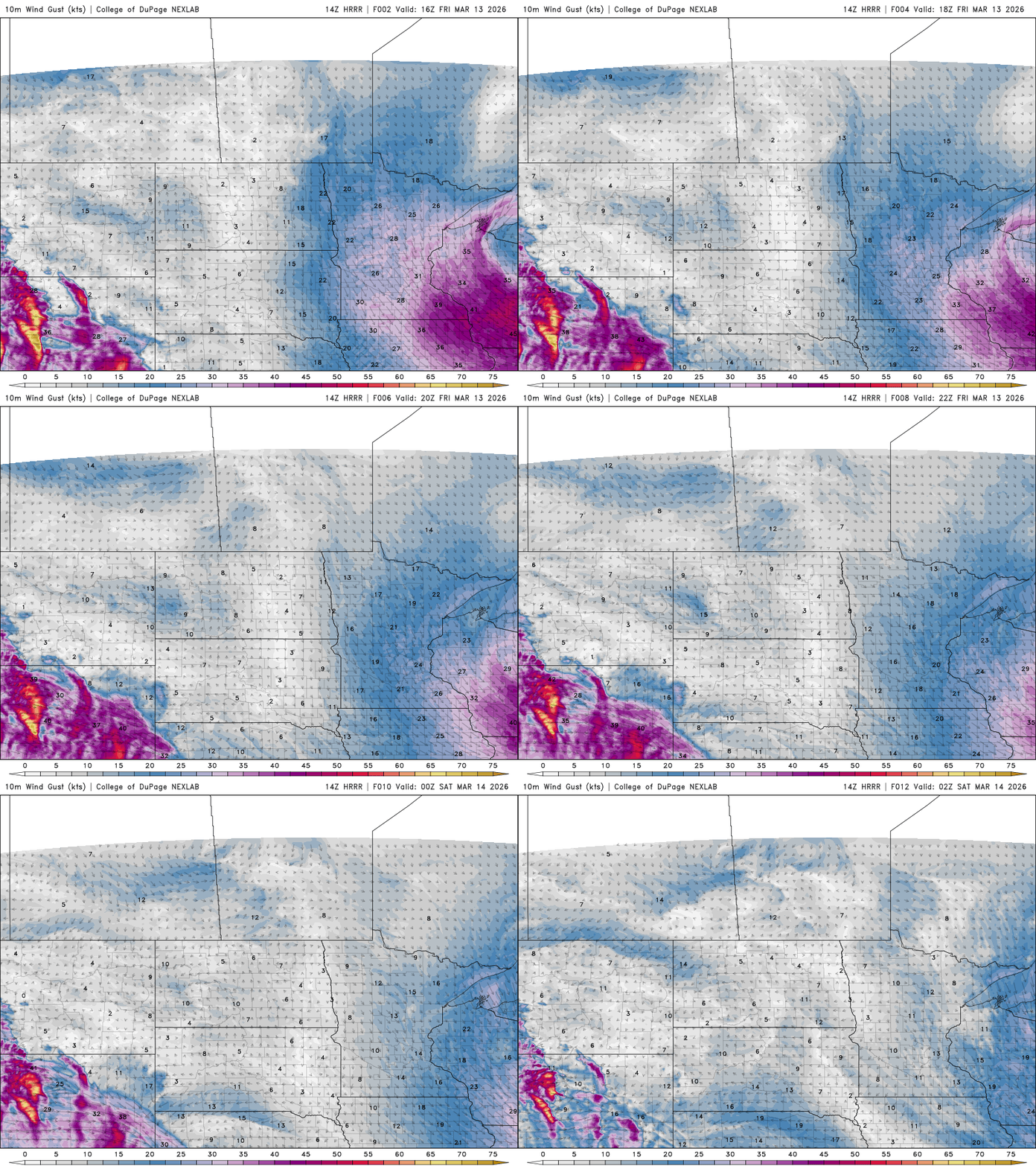
A powerful burst of overnight winds swept across the state Thursday night into Friday, with numerous locations reporting gusts over 60 mph and a few approaching the mid-70 mph range.
One of the strongest wind gusts reported was near Hector in Renville County at 74 mph. Other locations also experienced extremely strong winds. Canby recorded a 73 mph gust and Springfield measured 72 mph.
Several additional sites reported gusts above 65 mph, including:
Blue Earth — 71 mph
Dawson — 71 mph
Redwood Falls Airport — 71 mph
Benson Airport — 70 mph
Morris Airport — 68 mph
Clara City — 68 mph
Across the Twin Cities metro, the winds were also intense. Minneapolis-St. Paul International Airport reported a gust of 61 mph, while Crystal reached 64 mph and Eden Prairie reported a gust of 63 mph.
Winds will gradually ease later Friday, but gusty conditions are likely to continue through much of the afternoon.
Wind speed and direction for Friday 11 a.m. to 9 p.m.
Heavy snow fell across northern Minnesota Thursday night into early Friday. Freelance photojournalist Erica Dischino captured these images for MPR News.
13 of 13
Snow removal is underway Friday, March 13, 2026 in downtown Duluth, Minn. A winter storm warning is in effect along the North Shore.
Erica Dischino for MPR News
1 of 13
Shoveling snow began before the sun rose Friday, March 13, 2026 in Duluth, Minn. A winter storm warning is in effect along the North Shore.
Erica Dischino for MPR News
2 of 13
A skeleton with a Santa hat is buried in snow seen Friday, March 13, 2026 in Duluth, Minn. A winter storm warning is in effect along the North Shore.
Erica Dischino for MPR News
Lake Superior waves crash to the shore as a pedestrian walks along the Lakewalk Friday, March 13, 2026, near Canal Park in Duluth, Minn. A winter storm warning is in effect along the North Shore.
The first part of March started off warmer than usual with places like Pipestone and Worthington in southwestern Minnesota reaching 70 degrees.
“But now we're going to go the other way,” says climatologist and meteorologist Mark Seeley.
Temperatures are expected to dive to between 15 to 20 degrees below normal starting Sunday and lasting through Tuesday. Seeley said it’s often typical for the month of March to have such a range of highs and lows.
Seeley said he expects the Twin Cities will pick up a month’s worth of snowfall over the weekend, with at least 7 to 9 inches.
Listen to the full conversation by clicking the player above.
A snowplow clears Interstate 35E in Mendota Heights amid a winter storm on Dec. 28, 2025.
Wind gusts up to 70 mph swept across the southern half of Minnesota and caused power outages early Friday ahead of a another major storm this weekend.
Wet, heavy snow is forecast to start late Saturday in central and southern Minnesota.
Mike Griesinger, a forecaster at the National Weather Service in the Twin Cities, said anyone in the region with Sunday travel plans should try to reschedule.
“During the heart of the storm late Saturday night into Sunday morning we’ll likely have snowfall rates at 2 to 3 inches per hour, and there's not a snowplow in Minnesota that can keep up with that,” he said Friday morning.
Much of southern Minnesota can expect at least 6 inches of snow this weekend. The Weather Service says a band of up to 2 feet will likely hit somewhere between the Twin Cities and Rochester.
Griesinger said winds will diminish later Friday before picking up again later Saturday as the weekend storm approaches.
The Weather Service said blizzard conditions are possible in southern Minnesota at the peak of the storm on Sunday.
News you can use in your inbox
When it comes to staying informed in Minnesota, our newsletters overdeliver. Sign-up now for headlines, breaking news, hometown stories, weather and much more. Delivered weekday mornings.