Severe thunderstorms knocked out power to more than 60,000 overnight

Strong to severe storms produced wind gusts between 55 and 80 mph.

Xcel Energy outage map
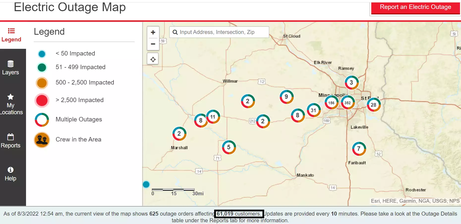
Xcel Energy outage map.
Xcel Energy

Update: 1 a.m.

Severe thunderstorms rolled through southern Minnesota including the Twin Cities overnight. As of this update at 1 a.m., more than 61,000 Xcel Energy customers are without power. That number has been growing.

The post below is a compilation of reports as the storms rolled through.

The storm produced a 62 mph wind gust at MSP Airport at 12:23 am.

Here are some select recorded wind gusts and storm reports as of 12:45 am.

Create a More Connected Minnesota

MPR News is your trusted resource for the news you need. With your support, MPR News brings accessible, courageous journalism and authentic conversation to everyone - free of paywalls and barriers. Your gift makes a difference.

  • 11:02 PM 3 W Hector [Renville Co, MN] DEPT OF HIGHWAYS reports TSTM WND GST of M81 MPH at 2 Aug, 11:02 PM CDT -- MNDOT WIND SENSOR WEST OF HECTOR.

  • 11:09 PM REDWOOD FALLS,MN (RWF) ASOS reports gust of 52 knots (59.8 mph) from NW

  • 11:15 PM OLIVIA,MN (OVL) ASOS reports gust of 56 knots (64.4 mph) from WNW @ 0415Z

  • 11:15 PM 2 SSW Hutchinson [Mcleod Co, MN] AWOS reports TSTM WND GST of M66 MPH at 2 Aug, 11:19 PM CDT -- KHCD - HUTCHINSON AIRPORT.

  • Hutchinson [Mcleod Co, MN] PUBLIC reports TSTM WND DMG at 2 Aug, 11:20 PM CDT -- PHOTOS ON SOCIAL MEDIA OF MEDIUM TO LARGE LIMBS DOWN ON ROADWAY. TIME ESTIMATED BY RADAR.

  • Norwood/Young America [Carver Co, MN] PUBLIC reports TSTM WND DMG at 2 Aug, 11:53 PM CDT -- FULL SIZE TREES DOWN REPORTED ON SOCIAL MEDIA IN NORWOOD YOUNG AMERICA.

  • 12:10 AM 2 SW Eden Prairie [Hennepin Co, MN] ASOS reports TSTM WND GST of M55 MPH at 12:10 AM CDT -- ASOS STATION KFCM EDEN PRAIRIE AP.

  • 12:20 AM 1 SSW Bloomington [Hennepin Co, MN] TRAINED SPOTTER reports TSTM WND GST of M67 MPH at 12:20 AM CDT --

  • 12:23 AM 2 E Richfield [Hennepin Co, MN] ASOS reports TSTM WND GST of M62 MPH at 12:23 AM CDT -- ASOS STATION KMSP MINNEAPOLIS-ST. PAUL AP.

  • 1 AM Xcel Energy outage map reports more than 57,000 customers without power.

Update 12:30 am

Latest severe thunderstorm warning includes eastern Twin Cities and western Wisconsin until 1:15 am.

Severe storms are moving through southern Minnesota late Tuesday night into Wednesday morning. A severe thunderstorm watch is up until 2 am including the Twin Cities.

Severe thunderstorm warnings include the greater Twin Cities area. Large hail and 70 mph winds are possible with storms.

This warning includes most of the Twin Cities.

BULLETIN - IMMEDIATE BROADCAST REQUESTED

Severe Thunderstorm Warning National Weather Service Twin Cities/Chanhassen MN

1152 PM CDT Tue Aug 2 2022

The National Weather Service in the Twin Cities has issued a

* Severe Thunderstorm Warning for... Southern Hennepin County in east central Minnesota... Northwestern Dakota County in east central Minnesota... Northeastern Scott County in east central Minnesota... Southeastern Anoka County in east central Minnesota... Ramsey County in east central Minnesota...

* Until 1230 AM CDT.

* At 1152 PM CDT, a severe thunderstorm was located over Victoria, or 19 miles southwest of Minneapolis, moving east at 60 mph. HAZARD...60 mph wind gusts. SOURCE...Radar indicated. IMPACT...Expect damage to roofs, siding, and trees.

* This severe thunderstorm will be near... Chanhassen and Excelsior around 1155 PM CDT. Eden Prairie, Shakopee and Prior Lake around 1200 AM CDT. Burnsville, Minnetonka, St. Louis Park, Savage and Hopkins around 1205 AM CDT. Edina, Richfield and MSP International Airport around 1210 AM CDT.

Other locations in the path of this severe thunderstorm include Bloomington, St. Paul, Eagan, Inver Grove Heights, South St. Paul and West St. Paul.