
Rain please? Tracking locally heavy rainfall potential this weekend
Scattered strong storms could dump locally heavy downpours this weekend.

Go Deeper.
Create an account or log in to save stories.
Like this?
Thanks for liking this story! We have added it to a list of your favorite stories.


It’s another round of Minnesota rainfall bingo this weekend.
Summer convective systems are notorious for dropping heavy rain in one town, and leaving the town next door parched. That patchwork rainfall pattern looks likely again this weekend.
Some of the storms could be slow-movers with heavy rainfall cores. In fact, a few forecast models are starting to get my attention for the possibility of some localized, multi-inch, flash flood level rainfall this weekend.
Weather chaos theory
This weekend’s weather maps remind me of that classic Edward Lorenz question surrounding chaos theory.
Turn Up Your Support
MPR News helps you turn down the noise and build shared understanding. Turn up your support for this public resource and keep trusted journalism accessible to all.
“Does the flap of a butterfly’s wings in Brazil set off a tornado in Texas?” — Edward Lorenz MIT
A weak frontal system will slowly cross Minnesota. Differential heating between sunny and cloudy areas may trigger a chaotic pattern of thunderstorms and outflow boundaries that will collide and create new cells.
The result will be a patchwork of occasional thunderstorms this weekend. It won’t rain all the time, but the coverage pattern will be random from hour to hour.
Check out the National Oceanic and Atmospheric Administration’s NAM 3 km model below. It shows an initial line in northwestern Minnesota Friday night. A few rain and thunder cells could reach the Twin Cities Saturday morning.
A more aggressive batch of thunderstorms looks likely to develop Saturday afternoon and evening across the Twin Cities and southern Minnesota.
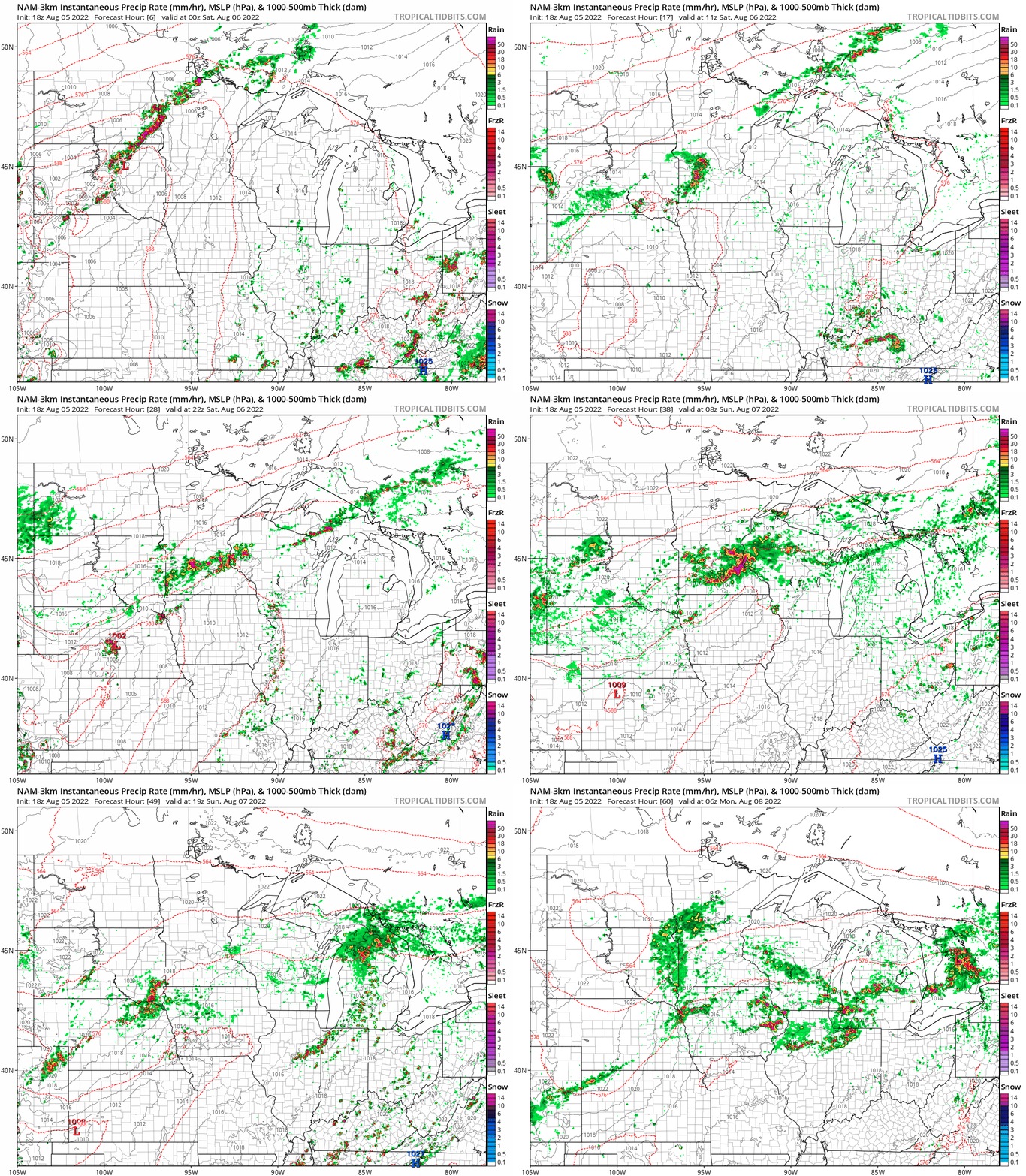
It appears some of these slow-moving cells Saturday have the potential to produce rainfall rates in excess of 1 to 2 inches per hour. That could mean localized flood issues.
If Edward Lorenz isn’t your thing, how about this flood-drought quote generally attributed to Mark Twain?
“It takes a flood to end a drought.” — Mark Twain
Here are two forecast model solutions for rainfall this weekend.
First, the European Centre for Medium-Range Weather Forecasts model paints widespread 1 to 2-inch rainfall totals with locally heavier amounts.

Now, here’s the National Oceanic and Atmospheric Administration’s Friday afternoon (18Z) NAM 3 km model solution. Check out the localized bands of 3 to 5-plus inches of rainfall. And yes, that’s a 7-inch rainfall bull’s-eye right over the Twin Cities by Monday morning.
As meteorologists, we urge you not to take forecast model rainfall placement literally for convective system, but use it as a gauge of what level of localized rainfall could occur in any one or more locations Saturday given eventual storm tracks.
Flash flood potential in a drought zone in Minnesota? Naturally.
Here’s hoping your lawn or farm field gets a much-needed soaking rainfall this weekend. And not all at once.

