
Weekend weather: Periods of rain, thunderstorms; heaviest in southern Minnesota
Severe weather outlooks have been updated

Go Deeper.
Create an account or log in to save stories.
Like this?
Thanks for liking this story! We have added it to a list of your favorite stories.


Thursday’s weather was outstanding. Our heat and humidity will ramp up Friday afternoon.
Areas of showers and thunderstorms are expected to spread into parts of west-central and northwestern Minnesota Friday afternoon and early Friday evening, then expand northeastward later Friday evening and overnight.
The National Weather Service Storm Prediction Center shows a slight risk of severe weather (shaded yellow) Friday afternoon and Friday evening into the overnight in parts of northwestern Minnesota:

Slight risk means that scattered severe thunderstorms are possible. An isolated severe thunderstorm is possible during that same time period in the darker green shaded areas.
Turn Up Your Support
MPR News helps you turn down the noise and build shared understanding. Turn up your support for this public resource and keep trusted journalism accessible to all.
Friday night in NWS lingo ends at 7 a.m. Saturday.
Weekend rain update
Periods of rain and thunderstorms are expected Saturday and Sunday in Minnesota and western Wisconsin. The highest weekend rainfall totals, 1 to 2 inches, are expected from the southern half of Minnesota eastward into Wisconsin. Localized higher amounts are possible.
You can hear updated weather information for Minnesota and western Wisconsin on the Minnesota Public Radio News network, and you can see updated weather info on the MPR News live weather blog.
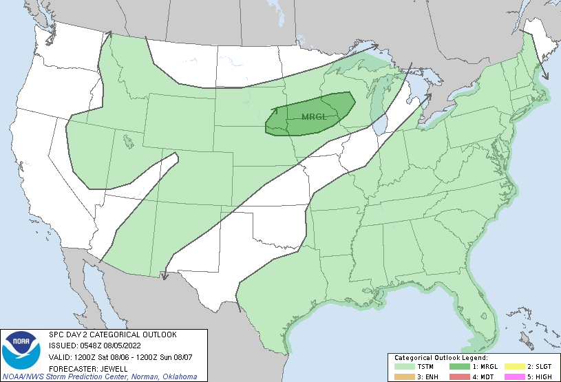
The Saturday-Saturday night severe weather outlook shows a marginal risk of severe weather in southern Minnesota, the southern portion of the Twin Cities metro area and parts of Wisconsin and northern Iowa:
Rain is really needed in some areas
The timing of the rain is unfortunate for people who have outdoor plans this weekend, but many areas could really use some rain.
The latest U.S. Drought Monitor report shows severe drought across much of the Twin Cities metro area and also in Sibley County and southeastern McLeod County:

The beige area on the map is in moderate drought, and the area that’s shaded yellow is abnormally dry but not currently in drought.
Weekend temps and dew points
Saturday highs will be in the 80s in the Twin Cities metro area and much of southern Minnesota, with mainly 70s elsewhere in Minnesota:

Parts of west-central and southwestern Wisconsin will top 90.
Saturday afternoon dew points will be in the steamy 70s from the Twin Cities into southeastern Minnesota, with sticky 60s in central and southwestern Minnesota:

Dew points will be in the comfortable 50s to the north.
Sunday highs will be in the 60s in northern Minnesota, with 70s elsewhere:

Sunday dew points will be in the comfortable 50s in northern Minnesota, with sticky 60s to the south:

Programming note
You can hear my live weather updates on MPR News at 7:35 a.m., 9:35 a.m. and 4:39 p.m. each Saturday and Sunday.

