Pattern change: Cooler temperatures, more clouds and some showers this week

Ther persistent heat of June and July is giving way to near average temperatures in August.
Temperatures
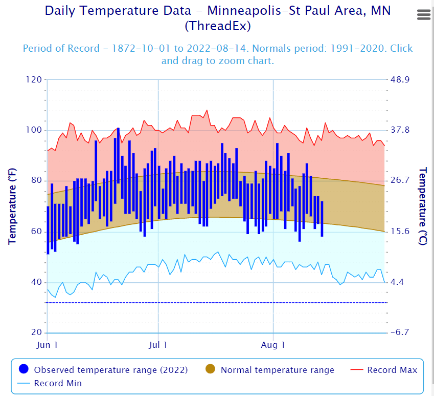
Temperatures at MSP Airport since June 1.
Twin Cities National Weather Service

We’re getting our money’s worth this summer for heat in Minnesota. You can see how temperatures on the bar graph above have run above average through most of June and July in the Twin Cities. But temperatures are trending cooler and closer to average so far in August.

Here are a few quick metrics.

  • June was 3.3 degrees warmer than average in the Twin Cities.

  • July was 2.0 degrees warmer than average in the Twin Cities.

  • 17 days have reached 90 degrees or higher in the Twin Cities so far this year.

  • 13 is the annual average number of days at or above 90 for the Twin Cities.

So far August is dealing us near average temperatures in most of Minnesota. Temperatures at MSP Airport are running 0.1 degrees below average through Aug. 14.

Cooler, cloudier, and wetter

Create a More Connected Minnesota

MPR News is your trusted resource for the news you need. With your support, MPR News brings accessible, courageous journalism and authentic conversation to everyone - free of paywalls and barriers. Your gift makes a difference.

The weather maps this week over Minnesota look cooler and wetter than the past several weeks. A series of weak but wetter weather systems are pushing more moisture into our region. That means more clouds through Tuesday, and eventually more scattered rains later this week.

NOAA’s GFS model gives you the idea of more frequent cloud cover this week. We’ll see some sunny breaks at times, but clouds will be a semi-persistent feature most days. The loop below runs between Monday afternoon and Friday evening.

NOAA GFS cloud forecast
NOAA GFS cloud forecast.
NOAA via tropical tidbits

Now check out the rainfall pattern. Showers will be widely scattered early this week, but coverage looks likely to increase later this week.

NOAA GFS precipitation output
NOAA GFS precipitation output through Friday.
NOAA via tropical tidbits

Rainfall totals by the end of this week look likely to reach an inch in many areas. The best chance for 2 or more inches appears to favor northern Minnesota. Here’s the European model rainfall output through Friday.

European model (ECMWF) precipitation output
European model (ECMWF) precipitation output through Friday.
ECMWF via pivotal weather

Highs this week will mostly be in the 70s across Minnesota, so it will feel cooler than the past several weeks.

Forecast high temperatures Tuesday
Forecast high temperatures Tuesday.
NOAA

Enjoy our free AC this week.