
Summer's last hurrah? October severe weather risk Tuesday
Storms could pack hail and high winds Tuesday evening

Go Deeper.
Create an account or log in to save stories.
Like this?
Thanks for liking this story! We have added it to a list of your favorite stories.


We’re moving into the middle of October this week but one more summery air mass appears ready to bring a severe weather risk to Minnesota on Tuesday.
Let’s start with this glorious Monday. Bright sunshine and temperatures in the 60s and low 70s are making for a beautiful day across Minnesota.

Monday night will be a lovely, windows-open, night with lows in the 50s south and some 40s north.
A shot at 80 Tuesday
Tuesday’s southerly breezes will pump even warmer air into Minnesota. The air mass appears capable of 80 degrees in southern Minnesota if we get enough sunshine in between cloud patches Tuesday.
Turn Up Your Support
MPR News helps you turn down the noise and build shared understanding. Turn up your support for this public resource and keep trusted journalism accessible to all.

Tuesday evening thunderstorms?
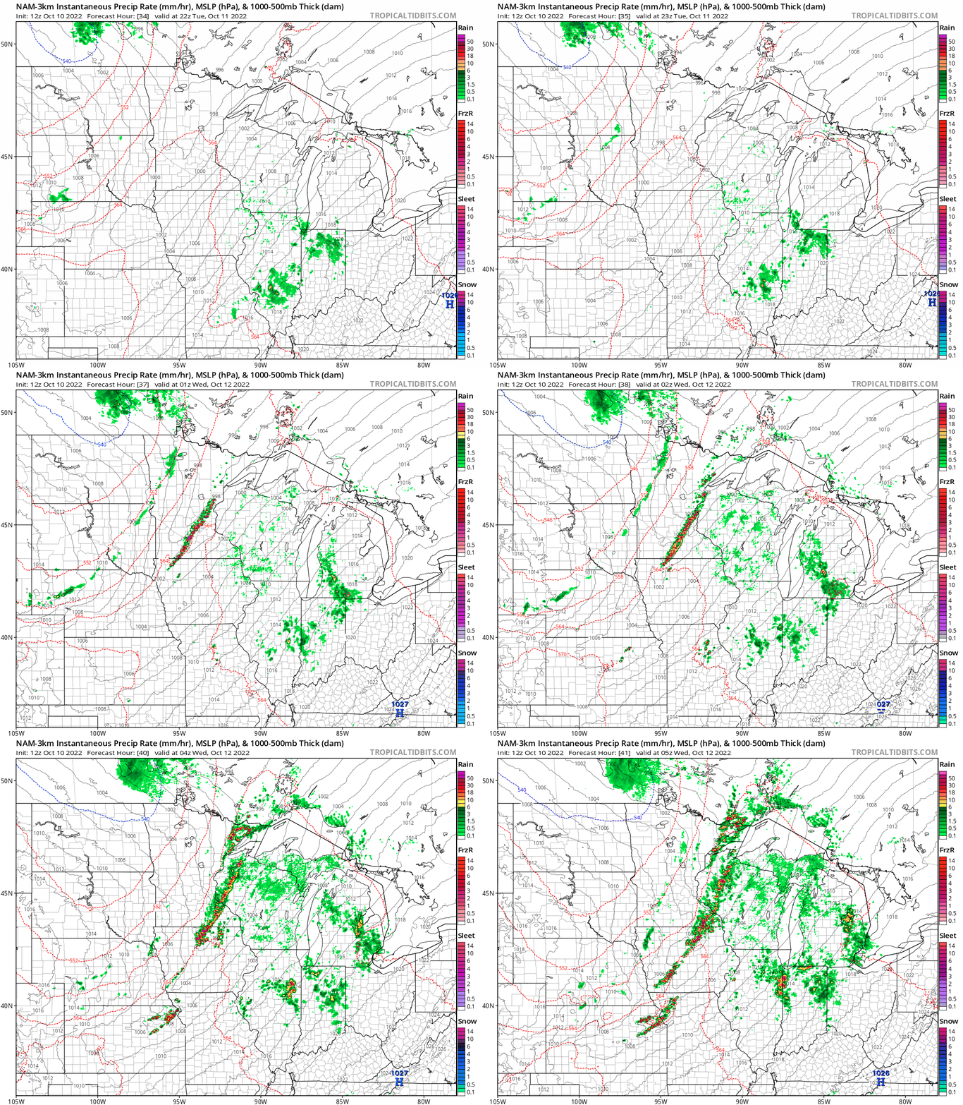
A cold front will cut through the warmer air mass across Minnesota late Tuesday. Many short-range forecast models suggest a line of storms could rapidly develop in the late afternoon warmth near or just west of the Twin Cities across central Minnesota.
The National Oceanic and Atmospheric Administration’s NAM 3 km resolution model blows up a pretty impressive line of cells just west of the Twin Cities around 6 p.m. to 7 p.m. Tuesday.
Severe weather risk
NOAA’s Storm Prediction Center lays out a marginal risk zone for severe weather across much of eastern Minnesota and Wisconsin Tuesday.
The primary threats with storms Tuesday are potentially severe hail greater than 1 inch in diameter and possible wind gusts to around 60 mph.
Here’s more detail if you want to geek out with NOAA’s convective outlook discussion for Tuesday.
...Upper MS Valley/Midwest into the central/southern Plains... Modest low-level moisture is expected to stream northward into parts of the Plains/Midwest and upper MS Valley during the day on Tuesday, in advance of the cold front. Relatively steep midlevel lapse rates will support the development of weak to locally moderate buoyancy, though a substantial capping inversion will likely limit thunderstorm initiation for much of the day. Large-scale ascent attendant to the cold front and amplifying upper-level trough may allow for thunderstorm development along the front during the evening, initially over parts of the upper Midwest/MS Valley, and then farther southwest into the central and possibly southern Plains by later Tuesday night.
Given the anticipated nocturnal timing of larger-scale storm development, initial convection will likely be somewhat elevated, but sufficient buoyancy and effective shear of 25-35 kt will support the potential for organized multicells and perhaps a supercell or two. Isolated hail may be the most prevalent threat, given favorably cool temperatures aloft and relatively steep midlevel lapse rates. However, even with convection likely to become increasingly elevated with time, isolated strong/damaging gusts cannot be ruled out, given the presence of relatively strong low-level flow and a residual well-mixed boundary layer across parts of the warm sector.
A broad Marginal Risk has been maintained for this outlook, though higher probabilities may eventually be needed across parts of the upper MS Valley/Midwest, especially if confidence increases in earlier, near-surface-based storm initiation. The threat becomes increasingly conditional with southwestward extent into the southern Plains, where the environment will be favorable for strong elevated storms late Tuesday night, but large-scale ascent will be weaker compared to areas to the northeast. ..Dean.. 10/10/2022
We need rainfall, so any rain Tuesday evening would be welcome in most areas. But mode forecast models suggest patchy rainfall coverage.
The European Centre for Medium-Range Weather Forecasts model blots out spotty rainfall patches that could reach an inch in a few lucky spots.

So enjoy our beautiful summery weather pattern through Tuesday. But keep an eye out for possible strong to severe storms late Tuesday.

