
Hard freeze: Minnesota headed for coldest night in 6 months
Highs in the 70s likely return to Minnesota this weekend
Go Deeper.
Create an account or log in to save stories.
Like this?
Thanks for liking this story! We have added it to a list of your favorite stories.


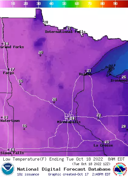
Get ready for the coldest night in almost six months, Minnesota.
A frigid Canadian air mass continues to pour south across Minnesota. The temperature bottomed out at 29 degrees in the Twin Cities Monday morning.
Tuesday morning will bring temperatures even colder. Lows will dip into the mid-20s in the Twin Cities, with teens in northern Minnesota. The last time the Twin Cities was as cold as 25 degrees was on April 19.
Gradually milder this week
This will be another dry week for drought-stricken Minnesota. We’ll see plenty of sunshine this week, and gradually warmer temperatures.
Turn Up Your Support
MPR News helps you turn down the noise and build shared understanding. Turn up your support for this public resource and keep trusted journalism accessible to all.
Highs will still hover in the 30s Tuesday.

Highs in the 50s and 60s will return to the Upper Midwest by Thursday and Friday. See the warmth building to the southwest?

40 degrees warmer this weekend
The upcoming weekend brings another shot of southerly breezes and milder air. Highs will push close to 70 in the Twin Cities and western Minnesota Saturday.
Sunday will be the warmest day. Most temperature products suggest highs in the lower 70s for the Twin Cities and western Minnesota Sunday.
The National Oceanic and Atmospheric Administration’s Global Forecast System model is more aggressive with the warmup. It cranks out highs in the mid to upper 70s across southern and western Minnesota, with 80 degrees possible in Iowa.

Forecast models often underestimate extreme temperature swings. Let’s see how warm it gets Sunday.
Stay tuned.

