Minnesota winter outlook: Will La Niña or climate change rule?

La Niña winters skew colder here but the climate change warming trend looks stronger

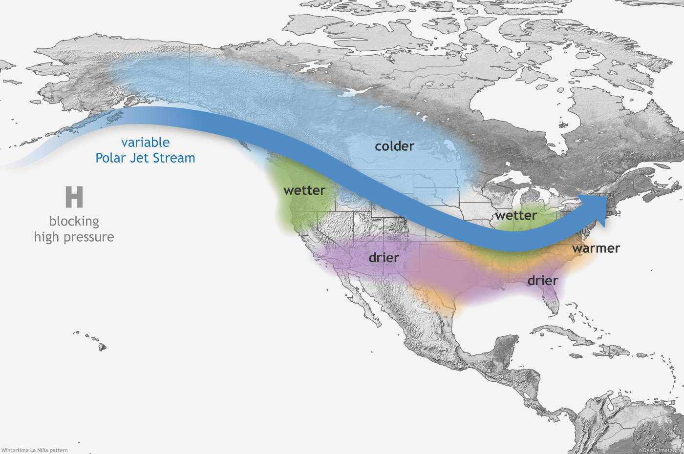
Typical La Nina winter pattern
National Oceanic and Atmospheric Administration

The National Oceanic and Atmospheric Administration says the odds of a colder-than-average winter in the Upper Midwest appear to be higher than average this year thanks to a third straight La Niña event.

However, a warming trend driven by climate change may be stronger.

Warmer winters
Warmer winters in the U.S.
Climate Central / NOAA data

So will La Niña or climate change win out this winter? Let’s assess.

NOAA winter outlook

This winter outlook released by NOAA on Thursday is based largely on the ongoing La Niña event in the tropical Pacific Ocean. This is now the third straight La Niña year. That’s happened only two other times since 1950 (1973-1976 and 1998-2001).

Create a More Connected Minnesota

MPR News is your trusted resource for the news you need. With your support, MPR News brings accessible, courageous journalism and authentic conversation to everyone - free of paywalls and barriers. Your gift makes a difference.

La Niña winters historically produce colder-than-average winters in Minnesota about 70 percent of the time.

Winter outlook 2
Winter temperature outlook
NOAA

NOAA’s winter outlook also calls for equal chances for above or below-average snowfall across most of Minnesota. The only area favoring above-average snowfall is the tip of Minnesota’s Arrowhead region surrounding Grand Marais.

Winter outlook
Winter outlook
NOAA / Duluth National Weather Service office

La Niña vs. climate change

It’s statistically true that Minnesota winters skew colder than average in most La Niña years, but the climate change forcing the effect of warmer winters in Minnesota appears to be stronger overall.

The Duluth National Weather Service office makes some good points with their winter outlook briefing Thursday. Here are some data points that stand out to me. This particular data is for Duluth:

  • In 24 La Niña winters, overall Dec-Feb temperatures averaged 2.0 degrees colder than average.

  • The past 2 La Niña winters have been very different in Duluth.

  • The La Niña winter of 2020-21 was warmer than average (+2.6 degrees) with below-average snowfall. (-12.5 inches)

  • The La Niña winter of 2021-22 was colder than average (-2.5 degrees) with above-average snowfall. (+15.1 inches”)

So you can see the character of the past two winters have been very different, even though both were La Niña winters.

la Nina winters
La Niña winter trends in Duluth.
Duluth National Weather Service office

Now let’s look at the effect of climate change on Minnesota winters.

As our climate shifts, winter is the fastest-warming season in Minnesota. NOAA data and analysis from Climate Central show Minnesota winters have warmed by 5.7 degrees on average since 1970.

Winter warming since 1970
Winter warming since 1970 in the Twin Cities.
Climate Central / NOAA data

So the climate change forcing signal (+5.7 degrees) is actually stronger than the La Niña cooling signal (-2 degrees) in Minnesota.

So the variability of individual La Niña events and the background forcing of warmer winters due to climate change make for a high degree of uncertainty in Minnesota’s winter forecast this year.

I’m much more confident in a forecast of warmer-than-average winters in El Niño years that favor warmer-than-average temperatures in Minnesota. In El Niño years, both the El Niño-Southern Oscillation and the climate change seasonal forcing factor are in alignment.

Stay tuned.