Still on track for snowy travel Tuesday; 3 to 6 inches likely for Twin Cities area
Both morning and afternoon rush hours look slick Tuesday.
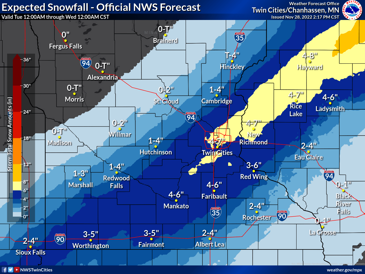
The latest forecast models Tuesday afternoon still confirm the trend for snow most of the day Tuesday.
The latest: View radar and live updates
Winter weather advisories have been posted from much of southern Minnesota through the Twin Cities into western Wisconsin.
Including the cities of Elk River, Cambridge, Center City, Monticello, Minneapolis, Blaine, St Paul, Stillwater, Hutchinson, Gaylord, Chanhassen, Chaska, Victoria, Shakopee, Hastings, New Ulm, St Peter, Le Sueur, Faribault, Red Wing, St James, Mankato, Waseca, Owatonna, Fairmont, Blue Earth, Albert Lea, Hudson, River Falls, Menomonie, Durand, and Chippewa Falls
235 PM CST Mon Nov 28 2022
...WINTER WEATHER ADVISORY IN EFFECT FROM 4 AM TO 9 PM CST TUESDAY...
* WHAT...Snow expected. Total snow accumulations of 3 to 6 inches. Highest snowfall totals will be found along a swath from near Mankato through the Twin Cities metro to near Rice Lake WI.
* WHERE...Portions of central, east central, south central and southeast Minnesota and west central Wisconsin.
* WHEN...From 4 AM to 9 PM CST Tuesday.
* IMPACTS...Plan on slippery road conditions. The hazardous conditions may impact both the mornings and evening commutes.
* ADDITIONAL DETAILS...Winter Storm Warnings may be issued if confidence increases in having snowfall totals in excess of 6 inches.
Here are some quick storm bullet points as of Monday evening.
Snow begins in southwest Minnesota around or after midnight.
Snow develops around the Twin Cities between about 3 and 6 am Tuesday.
The heaviest snow bands will likely occur in the Twin Cities area between 9 am and 3 pm Tuesday.
Snowfall rates between .5” and 1” per hour are possible at times.
Snowfall coverage will taper off from west to east Tuesday evening.
Overall the most likely snowfall totals around the Twin Cities favor 3 to 6 inches. There could be some locally heavier snowfall totals, especially in the south and eastern Twin Cities into Wisconsin.
Here is a look at statewide snowfall projections.

Safe travels Tuesday!
Grow the Future of Public Media
MPR News is supported by Members. Gifts from individuals power everything you find here. Make a gift of any amount today to become a Member!