Winter storm warning now includes Twin Cities area Tuesday

6 inches of snow possible around parts of the greater Twin Cities. Especially the southeastern metro into Wisconsin.

Winter storm warnings and advisories
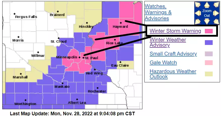
Winter storm warnings and advisories.
NOAA/Twin Cities National Weather Service

Buckle up, Twin Cities. Or maybe just work from home Tuesday if you are able.

Monday evening’s forecast model runs are boosting snowfall totals in the greater Twin Cities area.

As a result, the Twin Cities NWS has upgraded the Twin Cities and surrounding areas into winter storm warning mode. I’m still thinking a range of 3” to 6” is most likely for much of the Twin Cities (especially north and western Twin Cities) with the heaviest localized 6”+ totals in the southeast Twin Cities into northwest Wisconsin. The latest forecast models suggest much of the Twin Cities could pick up snowfall of 6 inches or more by Tuesday evening.

NWS
Winter storm warning.
Twin Cities National Weather Service

Here’s the warning text from the Twin Cities NWS.

Create a More Connected Minnesota

MPR News is your trusted resource for the news you need. With your support, MPR News brings accessible, courageous journalism and authentic conversation to everyone - free of paywalls and barriers. Your gift makes a difference.

Hennepin-Ramsey-Washington-Carver-Scott-Dakota-Polk-Barron- St. Croix- Including the cities of Minneapolis, St Paul, Stillwater, Chanhassen, Chaska, Victoria, Shakopee, Hastings, Osceola, Rice Lake, and Hudson

827 PM CST Mon Nov 28 2022

...WINTER STORM WARNING IN EFFECT FROM 5 AM TO 6 PM CST TUESDAY...

* WHAT...Heavy snow expected. Total snow accumulations of 4 to 7 inches, with locally higher amounts possible.

* WHERE...Portions of east central Minnesota and northwest and west central Wisconsin.

* WHEN...From 5 AM to 6 PM CST Tuesday.

* IMPACTS...Plan on slippery road conditions. The hazardous conditions will impact the morning and evening commutes.

PRECAUTIONARY/PREPAREDNESS ACTIONS... If you must travel, keep an extra flashlight, food, and water in your vehicle in case of an emergency. The latest road conditions for the state you are calling from can be obtained by calling 5 1 1.

Snow will begin before the AM rush hour in most areas, and last through most of Tuesday before tapering off Tuesday evening. Heavier snowfall rates of 1” per hour are possible between 9 am and 3 pm.

Here’s NOAA’s Monday evening (0Z) NAM 3 km model between 6 am and 6 pm Tuesday.

NOAA NAM 3 km model 2
NOAA NAM 3 km model between 6 am and 6 pm Tuesday.
NOAA via tropical tidbits

Overall snowfall totals over 6 inches appear quite possible from around the Twin Cities into western Wisconsin. But there could be a sharp dropoff in snowfall totals in the northwest Twin Cities.

Snowfall projection 33
Snowfall projection.
NOAA/Twin Cities National Weather Service

Here’s the latest statewide view.

Snowfall projection for Minnesota 2
Snowfall projection for Minnesota.
NOAA/Twin Cities National Weather Service

Stay safe out there!