Our massive, lollygagging, dayslong storm is finally beginning to wind down across Minnesota. The heaviest snow bands and bursts are over. Scattered, occasional snow showers will linger through Friday in many areas.
Check out the National Oceanic and Atmospheric Administration’s NAM 3 km model, which shows the center of the low-pressure storm swirling over the Twin Cities through noon Friday:
Overall, expect another 1 to 3 inches for many areas through Saturday. The North Shore could add another 5 inches in some areas.
Incredible snowfall totals
More than 2 feet of snow was reported at multiple locations along the North Shore and northeast Minnesota. As of this post, Finland still leads the Golden Snow Shovel contest with 29 inches of heavy wet snowfall up on the hills above Lake Superior.
Turn Up Your Support
MPR News helps you turn down the noise and build shared understanding. Turn up your support for this public resource and keep trusted journalism accessible to all.
It’s interesting to note that snowfall totals are lower along the lakeshore where it was warm enough for mixed precipitation. But as the air rose up the hill, adiabatic cooling changed it to heavy snowfall.
Air masses cool about 5 degrees for every 1,000 feet of elevation gain. That wrings out even more snow on the ridge tops.
Orographic snowfall enhancement
NOAA
This sprawling weather system dumped even heavier snowfall in South Dakota’s Black Hills, where 3 to 4 feet fell!
The forecast models for this week’s storm performed very well. First, they have a week’s lead time on a major system. Also, they pretty much nailed the thermal profile suggesting a rainy mix in the Twin Cities with the heaviest snowfall across northern Minnesota and the North Shore.
Eastern Minnesota may see a light wintry mix Saturday. Then a bigger, slower storm looks like it has the potential to dump some heavy snowfall across central and northern Minnesota.
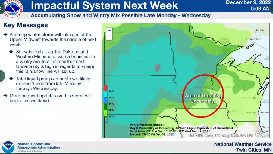
Right now the early forecast models suggest the freezing (rain-snow) zone could set up near the Twin Cities.
Storm outlook next week.
Twin Cities National Weather Service
Stay tuned.
The forecast models also nailed the two-part nature of this system.
A week’s lead time on a major winter storm with an accurate outcome? Overall, you can’t ask for much better model performance and lead time for Minnesota weather consumers. This storm was a big weather forecast success story.
Subzero air ahead next week
Next week brings a bitterly cold air mass into Minnesota. It will likely be our first prolonged subzero stretch of the cold season.
6 to 10-day temperature outlook
NOAA
The European and American models suggest teens below zero next week, with the upstream air mass capable of 20s to 30 below zero in southern Canada and northwestern Minnesota.
European model temperature forecast for 6 a.m. Wednesday, Dec. 21
European Centre for Medium-Range Weather Forecasts, via Pivotal Weather
Stay tuned.
News you can use in your inbox
When it comes to staying informed in Minnesota, our newsletters overdeliver. Sign-up now for headlines, breaking news, hometown stories, weather and much more. Delivered weekday mornings.