
Periods of light snow Saturday; colder Sunday and through the coming week
Winter weather advisories for parts of Minnesota Saturday
Go Deeper.
Create an account or log in to save stories.
Like this?
Thanks for liking this story! We have added it to a list of your favorite stories.


Kids with sleds and cross-country skiers are loving this snow. People who are shoveling twice a day are probably hoping for a break from this snow-globe weather pattern.
Periods of light snow continue today in Minnesota and Wisconsin. The light snow tapers to scattered flurries in most of Minnesota by late Saturday afternoon, with periods of light snow continuing Saturday evening in parts of western Wisconsin.
The areas of snow are rotating around a low pressure system that’s sitting just northeast of Lake Superior. That low will meander slowly away later today. A winter weather advisory continues until noon today in west-central through south-central Minnesota due to light snow and blowing snow plus reduced visibilities:

Here are details of the winter weather advisory:
Turn Up Your Support
MPR News helps you turn down the noise and build shared understanding. Turn up your support for this public resource and keep trusted journalism accessible to all.
URGENT - WINTER WEATHER MESSAGE National Weather Service Twin Cities/Chanhassen MN 647 AM CST Sat Dec 17 2022 MNZ041-047-048-054>057-064-065-067-073>075-082>084-091>093-171800- /O.CON.KMPX.WW.Y.0027.000000T0000Z-221217T1800Z/ Douglas-Stevens-Pope-Lac Qui Parle-Swift-Chippewa-Kandiyohi- Yellow Medicine-Renville-Sibley-Redwood-Brown-Nicollet-Watonwan- Blue Earth-Waseca-Martin-Faribault-Freeborn- Including the cities of Alexandria, Morris, Glenwood, Madison, Benson, Montevideo, Willmar, Granite Falls, Olivia, Gaylord, Redwood Falls, New Ulm, St Peter, St James, Mankato, Waseca, Fairmont, Blue Earth, and Albert Lea 647 AM CST Sat Dec 17 2022 ...WINTER WEATHER ADVISORY REMAINS IN EFFECT UNTIL NOON CST TODAY... * WHAT...Light snow and areas of blowing snow. Additional snow accumulations of up to one inch. Winds gusting as high as 35 mph. * WHERE...Portions of south central, southwest and west central Minnesota. * WHEN...Until noon CST today. * IMPACTS...Plan on slippery road conditions. Patchy blowing snow could significantly reduce visibility. PRECAUTIONARY/PREPAREDNESS ACTIONS... Slow down and use caution while traveling. The latest road conditions for the state you are calling from can be obtained by calling 5 1 1. Road conditions can also be found at 511mn.org for Minnesota or 511wi.gov for Wisconsin.
One inch or less of snow is expected in most of Minnesota today, including the Twin Cities metro area. Northeastern Minnesota and northwestern Wisconsin could see one to two inches of additional snow today. A winter weather advisory continues until 6 p.m. today from Pine County up through much of northeastern Minnesota and into far northwestern Wisconsin:

Here are details of that winter weather advisory:
URGENT - WINTER WEATHER MESSAGE National Weather Service Duluth MN 717 AM CST Sat Dec 17 2022 MNZ037-038-WIZ001-002-006-007-180000- /O.EXT.KDLH.WW.Y.0036.000000T0000Z-221218T0000Z/ Carlton and South St. Louis-Pine-Douglas-Bayfield-Burnett- Washburn- Including the cities of Duluth, Pine City, Hinckley, Superior, Washburn, Bayfield, Grantsburg, and Spooner 717 AM CST Sat Dec 17 2022 ...WINTER WEATHER ADVISORY NOW IN EFFECT UNTIL 6 PM CST THIS EVENING... * WHAT...Snow. Additional snow accumulations of up to two inches. * WHERE...In Minnesota, Carlton and South St. Louis and Pine Counties. In Wisconsin, Douglas, Bayfield, Burnett and Washburn Counties. This includes the Tribal Lands of the Red Cliff Band, the Fond du Lac Band and the Mille Lacs Band, Lena Lake and, Hinckley areas. * WHEN...Until 6 PM CST this evening. * IMPACTS...Plan on slippery road conditions. PRECAUTIONARY/PREPAREDNESS ACTIONS... Slow down and use caution while traveling. The latest road conditions can be obtained by calling 5 1 1. Road conditions can also be found at 511mn.org for Minnesota or 511wi.gov for Wisconsin.
You can find updated weather information for Minnesota and western Wisconsin on the Minnesota Public Radio News network, and on the MPR News live weather blog.
Temps and wind chill
Our average Twin Cities high temperature is 28 degrees on Dec. 17. We’ll have metro area highs in the lower 20s Saturday. Western Minnesota will have Saturday highs in the teens, with mainly 20s in eastern Minnesota and western Wisconsin. Below-zero wind chills are expected Saturday afternoon in western Minnesota, with wind chills slightly above zero in the east.
Sunday highs will be in the teens in many areas, with single-digit highs in far western Minnesota:

Sunday afternoon wind chill temps will be below zero in many areas, but slightly above zero from the Twin Cities into southeastern Minnesota:

Back to forecast high temperatures, Twin Cities metro area highs are projected to be in the mid-teens on Monday, followed by lower teens Tuesday then around 8 on Wednesday and around 4 above zero Thursday and Friday.
Monday PM snow chance
Some scattered light snow showers could move into western Minnesota Monday morning, then spread to cover much of Minnesota and western Wisconsin Monday afternoon and evening.
The National Oceanic and Atmospheric Administration’s North American Mesoscale (NAM) forecast model shows the potential snow pattern from 6 a.m. Monday to 9 p.m. Monday:
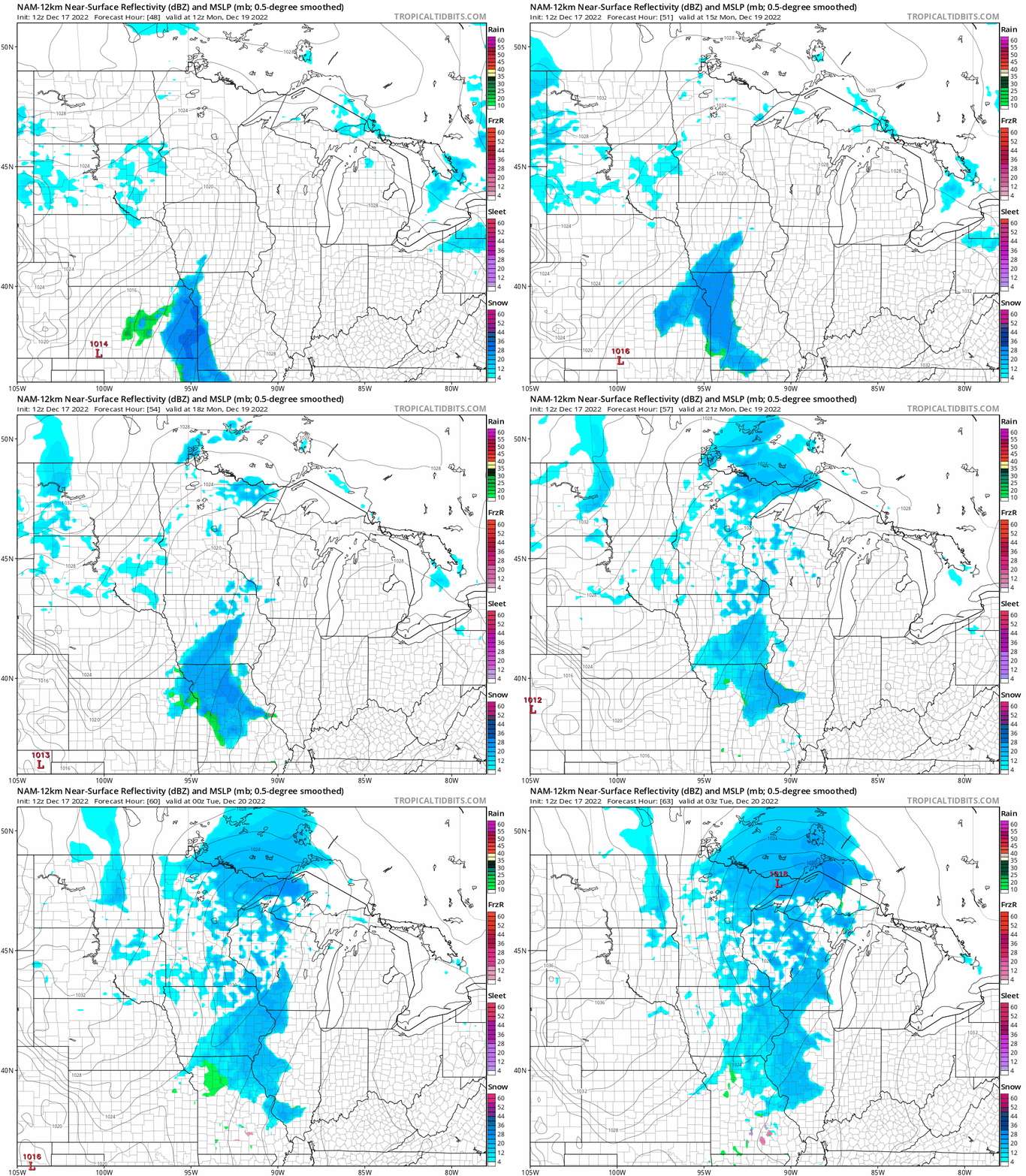
Another batch of snow is possible Wednesday and Wednesday night, and some forecast models give us several inches of snow during that period. Check back for updates in the coming days.
Storm totals
The same low pressure system has been dropping periods of snow on Minnesota and Wisconsin since Tuesday.
We have a new highest storm total, with 30.5 inches reported 6 miles northeast of Rice Lake in northeastern Minnesota:

The note for that snow tally says that the measurement location is on a terrain ridge. That would enhance storm snowfall totals.
You can check northeastern Minnesota snowfall totals here. A Twin Cities centered map of Minnesota and western Wisconsin snow reports can be found here.
Set the slider at the top of the linked map pages to “72 hours” to get the most complete storm totals. You can pan and zoom the map at the linked site to get snow totals plus the time and location of the snow measurement.
Weather nugget
Our average Twin Cities temperature (average of all the daily high temps and low temps) was 1.3 degrees warmer than normal over the first 16 days of December. Much colder weather is expected over the next 7 to 10 days, so we’ll end up with a colder than normal December. April was our last colder than normal month in the Twin Cities.
Programming note
You can hear my live weather updates on MPR News at 7:35 a.m., 9:35 a.m. and 4:39 p.m. Saturday and Sunday.

