Twin Cities set for snowy Wednesday morning rush

Light snow, colder temps could make for slick roads

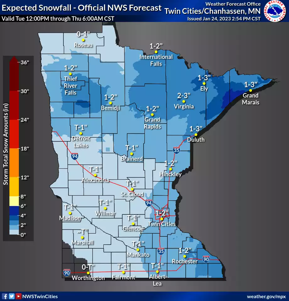
Snowfall projection for Minnesota
National Oceanic and Atmospheric Administration

It may not be a major storm, but Wednesday’s light snow will come during morning rush hours and, combined with colder temperatures, will likely cause some stealthily slick roads.

Overall snowfall accumulations (above) look light through Wednesday. But many areas could see an inch or two around the Twin Cities by Wednesday evening, with 1 to 4 inches more common up north.

Alberta clipper

This is the first of two Alberta clippers sailing through Minnesota this week.

A weak low-pressure system will drift southeast across Minnesota through Wednesday. Bands of mostly light snow will increase overnight and will likely move into the Twin Cities before and through Wednesday morning’s rush hour.

Create a More Connected Minnesota

MPR News is your trusted resource for the news you need. With your support, MPR News brings accessible, courageous journalism and authentic conversation to everyone - free of paywalls and barriers. Your gift makes a difference.

The National Oceanic and Atmospheric Administration’s latest NAM 3 km model shows pretty widespread snow coverage through Wednesday. Most of the snow will be light, but there could be a couple of hours of more moderate snow during Wednesday morning’s rush hours. Bad timing.

The loop below runs between 6 p.m. Tuesday and 3 p.m. Wednesday.

NOAA NAM 3 km model Wednesday
North American Mesoscale Forecast System 3 km model between 6 p.m. Tuesday and 3 p.m. Wednesday
NOAA, via Tropical Tidbits

Temperatures early Wednesday will bottom out from the teens west to mid-20s east. That means it will be cold enough for slick spots Wednesday morning.

Forecast low temperatures Wednesday
NOAA

Stay safe out there, Minnesota.