One more subzero shot Thursday then a weekend thaw

High in the mid to upper 30s by Sunday?
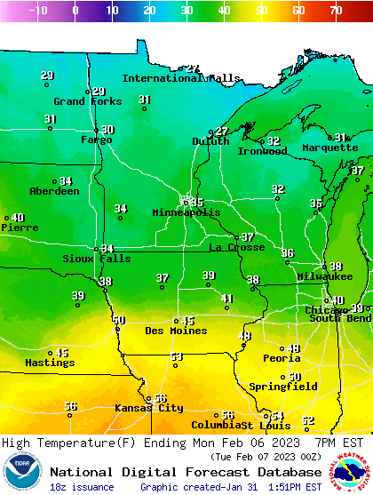
Forecast high temperatures Monday
National Oceanic and Atmospheric Administration

Wednesday brings the final month of meteorological winter.

We’re now two-thirds of the way through this meteorological winter in Minnesota. Here’s where we stand so far with temperatures and snowfall for the Twin Cities compared to average:

Temperature

  • December, 4 degrees cooler

  • January, 4.6 degrees warmer

  • Overall, 0.3 degree warmer

Snowfall

Create a More Connected Minnesota

MPR News is your trusted resource for the news you need. With your support, MPR News brings accessible, courageous journalism and authentic conversation to everyone - free of paywalls and barriers. Your gift makes a difference.

  • Twin Cities, 55.5 inches (25.5 inches above average)

  • Duluth, 80 inches (27.6 inches above average)

February will decide where we land with above or below-average temperatures. Right now, the outlooks slightly favor warmer-than-average temperatures through mid-month.

NOAA 8 to 14-day temperature outlook
8 to 14-day temperature outlook
NOAA

Arctic chill again Thursday

There’s little chance for significant snow this week. Temperatures moderate through Wednesday with highs approaching 20 degrees Wednesday afternoon in southern Minnesota.

Forecast high temperatures Wednesday
NOAA

Another arctic front barrels south Thursday. Temperatures will fall well below zero again Thursday night into Friday morning.

Forecast low temperatures Friday morning
NOAA

Weekend thaw

This weekend brings a milder Pacific air mass to Minnesota. Highs will reach the 30s (above zero) once again this weekend through Monday.

Forecast high temperatures Monday
NOAA