
Rare February soaking rain; blizzard Tuesday night in western Minnesota
An inch of rain for many; Twin Cities set for a little wet snow overnight into Wednesday
Go Deeper.
Create an account or log in to save stories.
Like this?
Thanks for liking this story! We have added it to a list of your favorite stories.


It’s an unusual Valentine’s Day weather map across Minnesota. Rare February rain is soaking the snowpack across much of Minnesota.
Subfreezing air is about to slam into western Minnesota and turn rain to snow, with blizzard conditions developing Tuesday night.

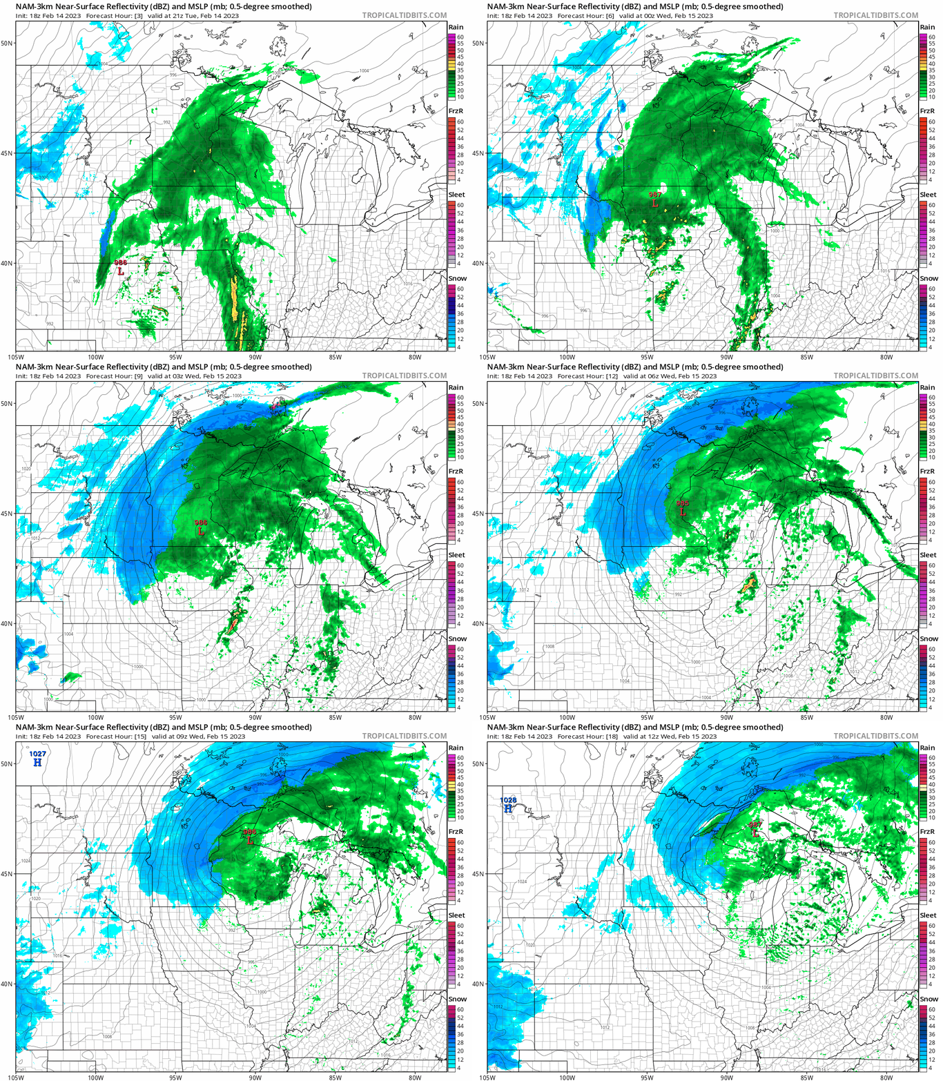
The National Oceanic and Atmospheric Administration’s NAM 3 km model (top of post) shows the system swirling into Minnesota Tuesday.
Notice how it’s warm enough for mostly rain (green) during the afternoon hours, with snow (blue) developing in western Minnesota as we move into Tuesday evening.
Turn Up Your Support
MPR News helps you turn down the noise and build shared understanding. Turn up your support for this public resource and keep trusted journalism accessible to all.
The rain is likely to change to a little wet snow on the backside of the system in the Twin Cities area in the hours around midnight. The loop runs between 3 p.m. Tuesday and 6 a.m. Wednesday.
Record February rainfall
This system is warm enough for all rain today in the Twin Cities and much of Minnesota. Steady light to moderate rains will likely produce an inch of from near Redwood Falls in southwestern Minnesota through the Twin Cities into Wisconsin.

The daily record for precipitation today at Minneapolis-St. Paul International Airport is 43 one-hundredths of an inch (.43) set in 1950. We’ll likely smash that one Tuesday.
Also, the record high minimum temperature for the Twin Cities on Valentine’s Day is 33 degrees. Temperatures will likely stay at or above 33 degrees through midnight. That would set another record.
Blizzard warning
The pressure gradient will tighten rapidly tonight across western Minnesota. That will cause wind over 50 mph in many areas.

Snow will be blowing sideways across the prairie, and that will make for difficult to impossible travel through Wednesday morning. Blizzard warnings are up for the Red River Valley and much of western Minnesota starting between 6 p.m. and 9 p.m. Tuesday night through noon Wednesday.

Including the cities of Alexandria, Morris, and Glenwood
700 AM CST Tue Feb 14 2023
...BLIZZARD WARNING REMAINS IN EFFECT FROM 9 PM THIS EVENING TO 10 AM CST WEDNESDAY...
* WHAT...Blizzard conditions expected. Total snow accumulations of 3 to 4 inches. Winds gusting as high as 55 mph.
* WHERE...Douglas, Stevens and Pope Counties.
* WHEN...From 9 PM this evening to 10 AM CST Wednesday.
* IMPACTS...Plan on slippery road conditions. Widespread blowing snow could significantly reduce visibility. The hazardous conditions could impact the morning commute. Gusty winds could bring down tree branches. The cold wind chills as low as 20 below zero could cause frostbite on exposed skin in as little as 30 minutes.
* ADDITIONAL DETAILS...Rain today will turn to snow from west to east this evening as much colder air arrives. A period of moderate snow will occur late evening and overnight as winds increase steadily and gust as high as 55 mph. A flash freeze and whiteout conditions are likely.
Rain will change to snow from west to east across Minnesota Tuesday evening. Snow will likely develop in the greater Twin Cities from west to east in the hours surrounding and after midnight. Overall snowfall totals look light in eastern Minnesota.

Windy and colder weather follow the system Thursday.

