
Weekend weather: Highs in the 30s; rain-snow Sunday afternoon
Heaviest snow in central Minnesota

Go Deeper.
Create an account or log in to save stories.
Like this?
Thanks for liking this story! We have added it to a list of your favorite stories.


Updated 5:15 p.m.
It was a pleasant Friday afternoon. Much of Saturday will be pleasant after areas of morning fog.
Weekend temps
The average Twin Cities high temperature is 36 degrees on March 4. Metro area highs are forecast to be very close to normal this Saturday.
Saturday highs will be in the 30s across most of Minnesota plus western Wisconsin:

Parts of northwestern and west-central Minnesota could top out in the upper 20s. Winds will be light on Saturday.
Turn Up Your Support
MPR News helps you turn down the noise and build shared understanding. Turn up your support for this public resource and keep trusted journalism accessible to all.
Sunday highs will be in the 30s in most locations, with some lower 40s in southeastern Minnesota:

Periods of rain-snow start Sunday afternoon
Winds will pick up on Sunday as a low-pressure system approaches. It’s expected to spread some rain and snow into Minnesota and western Wisconsin Sunday afternoon and evening. The precipitation will continue overnight Sunday night in some areas.
The National Oceanic and Atmospheric Administration’s North American Mesoscale (NAM) forecast model shows the potential precipitation pattern from 8 a.m. Sunday to 6 a.m. Monday:
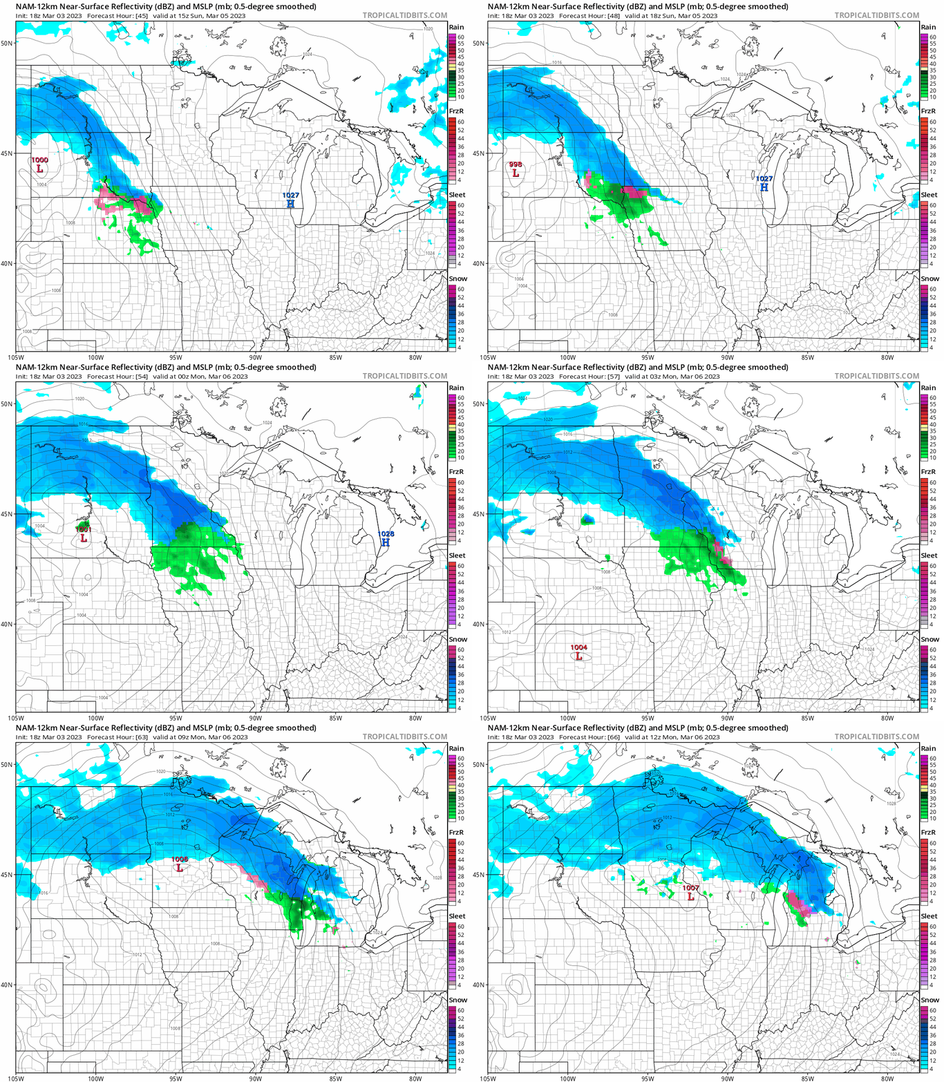
Southern Minnesota and the Twin Cities metro area could see a mix of rain and snow at times or even some periods of rain before it transitions back to snow.
The Twin Cities metro area may see an inch or two of slushy snow from Sunday afternoon into Sunday night, with higher snow totals possible in central Minnesota. Much of northeastern Minnesota will see the snow continue into Monday, with two-day totals of 5 to 10 inches:

There could be some 5-inch snow totals between Alexandria and Brainerd.
You can find updated weather information for Minnesota and western Wisconsin on the Minnesota Public Radio News network, and on the MPR News live weather blog.
Winter storm watch
A winter storm watch, for several inches of snow plus reduced visibilities in blowing snow, covers much of central and southern North Dakota and three counties in western Minnesota Sunday into Monday morning::

Here are winter storm watch details for the Moorhead, Minnesota area:
URGENT - WINTER WEATHER MESSAGE National Weather Service Grand Forks ND 255 PM CST Fri Mar 3 2023 MNZ002-003-029-NDZ028>030-039-053-061800- /O.NEW.KFGF.WS.A.0003.230305T1500Z-230306T1800Z/ Norman-Clay-Wilkin-Griggs-Steele-Traill-Cass-Richland- Including the cities of Ada, Twin Valley, Halstad, Moorhead, Breckenridge, Cooperstown, Finley, Hope, Mayville, Hillsboro, Hatton, Portland, Fargo, and Wahpeton 255 PM CST Fri Mar 3 2023 ...WINTER STORM WATCH IN EFFECT FROM SUNDAY MORNING THROUGH MONDAY MORNING... * WHAT...Heavy snow and blowing snow possible. Total snow accumulations of 4 to 7 inches possible. Winds could gust as high as 45 mph. * WHERE...Portions of northwest and west central Minnesota and southeast North Dakota. * WHEN...From Sunday morning through Monday morning. * IMPACTS...Travel could be very difficult. Widespread blowing snow could significantly reduce visibility. The hazardous conditions could impact the Monday morning commute. PRECAUTIONARY/PREPAREDNESS ACTIONS... Monitor the latest forecasts for updates on this situation.
Snow depths
There’s plenty of snow on the ground across most of Minnesota.
Here’s the latest snow depth map from the Minnesota State Climatology Office:

The snow depth at Minneapolis-St. Paul International Airport is currently listed at 7 inches, but many parts of the metro area have snow depths of 8 to 12 inches. Some higher amounts are found in the north metro.
Snow depths of 18 inches or higher are reported across much of central and northeastern Minnesota, with 24 to 30 inches in the light-purple shaded areas of northeastern Minnesota.
Programming note
You can hear my live weather updates on MPR News at 7:35 a.m., 9:35 a.m. and 4:39 p.m. Saturday and Sunday.

