
Update on Sunday rain chances, plus a look at the hot week ahead
Dew points will be sticky
Go Deeper.
Create an account or log in to save stories.
Like this?
Thanks for liking this story! We have added it to a list of your favorite stories.


Much of Minnesota and western Wisconsin will see showers at times this Father’s Day. There could also be a few scattered thunderstorms this afternoon and early evening.
By mid-to-late Sunday afternoon, the shower and thunderstorm chance is expected to be highest from portions of eastern Minnesota into western Wisconsin. Some locations will carry that rain chance into early evening.
You can find updated weather information for Minnesota and western Wisconsin on the MPR News network. Find the latest radar here.
You can also check these National Weather Service sites for updated weather info: Twin Cities, Duluth, La Crosse, Wis., Sioux Falls, S.D., Grand Forks, N.D.
Turn Up Your Support
MPR News helps you turn down the noise and build shared understanding. Turn up your support for this public resource and keep trusted journalism accessible to all.
Temperature trends
The average Twin Cities high temperature is 80 degrees this time of year. The metro area and much of Minnesota and western Wisconsin will have Sunday highs in the 70s, with a few lower 80s in far western Minnesota.
Juneteenth highs on Monday will be much warmer, reaching the upper 80s to around 90 in many locations:

70s are expected in northeastern Minnesota and far northwestern Wisconsin.
Much of Minnesota and western Wisconsin will have dew points in the sticky 60s Monday afternoon:

Tuesday high temps reach 90 degrees or warmer in many areas:

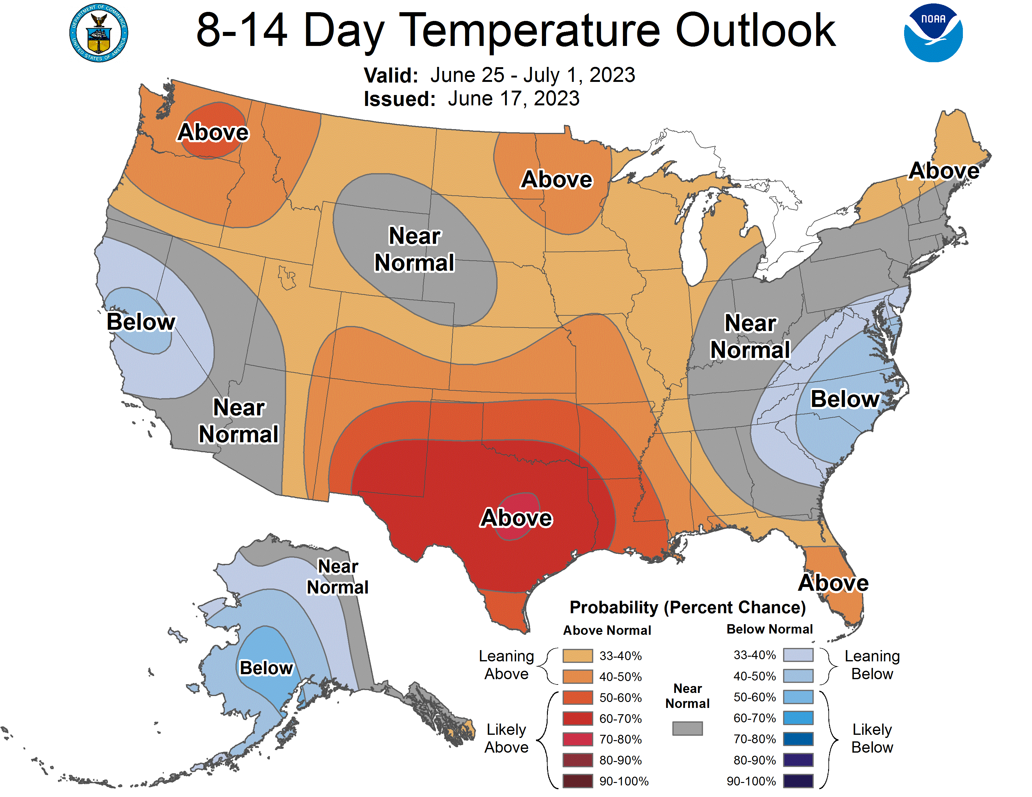
I see Twin Cities metro area highs in the lower 90s Tuesday, Wednesday and Thursday, then around 90 on Friday and Saturday. I wouldn’t be surprised to see a high in the mid-90s on either Wednesday or Thursday.
Warmer than normal temps are also expected next Sunday and into the following week. Here’s the June 25 through July 1 temperature outlook from the NWS Climate Prediction Center:
Saturday’s rain was west and south
Many parts of Minnesota were either abnormally dry (yellow) or in actual drought (beige and orange) on the U.S. Drought Monitor map that was released on Thursday:

It was nice to see that parts of western Minnesota and south-central Minnesota had meaningful rainfall totals Saturday and Saturday night:

An observer near Chokio, in western Stevens County of west-central Minnesota, had 5.50 inches of rain Saturday. Most areas that saw rain received less than one inch.
It’ll be interesting to see how many places see meaningful rain today.
Weather nugget
The official Twin Cities high temperature (measured at MSP airport) has been 90 degrees or warmer on 3 days this June. The highest number of June days with a high of 90 degrees or warmer in Twin Cities weather records is 17 days, in 1933.
Programming note
You can hear my live weather updates on MPR News at 7:35 a.m., 9:35 a.m. and 4:39 p.m. each Saturday and Sunday.

