
Air quality alert update; Some hot temps are in the forecast this week
Spotty strong storms are possible Monday evening
Go Deeper.
Create an account or log in to save stories.
Like this?
Thanks for liking this story! We have added it to a list of your favorite stories.


The Minnesota Pollution Control Agency continues an air quality alert Sunday and until 6 p.m. Monday in much of northern and central Minnesota. The MPCA has added Wright, Hennepin, Anoka, Ramsey and Washington counties of the metro area to the air quality alert until 6 a.m. Monday.

Here are air quality alert details, from the MPCA:
The Minnesota Pollution Control Agency (MPCA) has expanded the current air quality alert for central and northern Minn. to include the northern half of the Twin Cities metro. The expanded alert area in the Twin Cities metro is effective until 6 a.m. on Monday, July 24. The original alert area remains in effect until 6 p.m. on Monday. The affected areas include the Twin Cities, Brainerd, Alexandria, Hinckley, St. Cloud, Bemidji, International Falls, Two Harbors, Hibbing, Ely, Duluth, Roseau, and the tribal nations of Mille Lacs, Leech Lake, Red Lake, Grand Portage, and Fond du Lac.
Heavy ground-level smoke from wildfires in northern Alberta and British Columbia will impact northern and central Minn. on Sunday. Light northerly winds have brought this smoke into the northern half of the Twin Cities metro. Fine particle levels will reach the orange (unhealthy for sensitive groups) category across northern and central Minn., including the northern half of the Twin Cities metro on Sunday. Air quality across the southern Twin Cities metro and southern Minn. will be in the yellow (moderate) category. Winds will become southerly during the overnight hours on Monday and the smoke will begin to retreat north. Air quality should improve below the Orange category across the Twin Cities by Monday morning. Across central Minnesota and north central Minn., air quality is expected to improve below the orange category by Monday evening. Smoke will linger the longest across northeast Minn., and air quality is expected to remain in the orange category across northeast Minn. until the end of the day Monday.
Fine particle levels are expected to reach the orange air quality index (AQI) category, a level considered unhealthy for sensitive groups. In the orange area, sensitive groups should limit prolonged or heavy exertion and time spent outdoors.
You can check the hourly Minnesota air quality measurements here.
Here’s some additional air quality info, from the MPCA:
Turn Up Your Support
MPR News helps you turn down the noise and build shared understanding. Turn up your support for this public resource and keep trusted journalism accessible to all.
What this alert means
Air moves long distances and carries pollutants. During air quality alerts due to wildfires, the air is mixed with harmful smoke. Wildfire smoke spreads or lingers depending on the size of the fires, the wind, and the weather.
The air quality index (AQI) is color-coded. Air quality alerts are issued when the AQI is forecast to reach an unhealthy level, which includes forecasts in the orange, red, purple, and maroon categories. For a full description of each air quality category, visit airnow.gov.
Orange air quality: Unhealthy for sensitive groups
Sights and smells: In areas where air quality is in the orange AQI category due to wildfires, the sky may look hazy and residents may smell smoke even when wildfires are far away.
Health effects: This air is unhealthy for sensitive groups and pollution may aggravate heart and lung disease as well as cardiovascular and respiratory conditions. Symptoms may include chest pain, shortness of breath, wheezing, coughing, and fatigue.
What to do: People in sensitive groups are encouraged to reduce outdoor physical activities, take more breaks, or do less intense activities to reduce their exposure. People with asthma should follow their asthma action plan and keep their rescue inhaler nearby.
Who’s most at risk
Poor air quality impacts health. Fine particle pollution from wildfire smoke can irritate eyes, nose, and throat, and cause coughing, chest tightness, shortness of breath, dizziness, or fatigue. Smoke particles are small enough that they can be breathed deeply into lungs and enter the bloodstream. This can lead to illnesses such as bronchitis or aggravate existing chronic heart and lung diseases, triggering heart palpitations, asthma attacks, heart attacks, and strokes.
Certain groups experience health effects from unhealthy air quality sooner than others, either because they are more sensitive to fine particle pollution or because they are exposed to larger amounts of it.
Sensitive groups include:
People who have asthma or other breathing conditions like chronic obstructive pulmonary disease (COPD).
People who have heart disease, high blood pressure, or diabetes.
Pregnant people.
Children and older adults.
People with increased exposure include:
People of all ages who do longer or more vigorous physical activity outdoors.
People who work outdoors, especially workers who do heavy manual labor.
People who exercise or play sports outdoors, including children.
People who don’t have air conditioning and need to keep windows open to stay cool.
People in housing not tight enough to keep unhealthy air out, or who do not have permanent shelter.
Anyone experiencing health effects related to poor air quality should contact their health care provider. Those with severe symptoms, chest pain, trouble breathing, or who fear they may be experiencing a heart attack or stroke should call 911 immediately.
Take precautions
Reduce or eliminate activities that contribute to air pollution, such as outdoor burning, and use of residential wood burning devices. Reduce vehicle trips and vehicle idling as much as possible. Keep windows closed to ensure outside smoke does not enter your home.
Shower and thunderstorm chances are spotty
Northern Minnesota and northwestern Wisconsin could see some scattered showers and thunderstorms Sunday evening.
An isolated shower or thunderstorm is possible in Minnesota and western Wisconsin Monday morning, but the better chance of scattered showers and thunderstorms develops later Monday afternoon into Monday evening.
The NWS Storm Prediction Center shows a marginal risk (darker green) of severe weather Monday and Monday night in portions of Minnesota and Wisconsin:
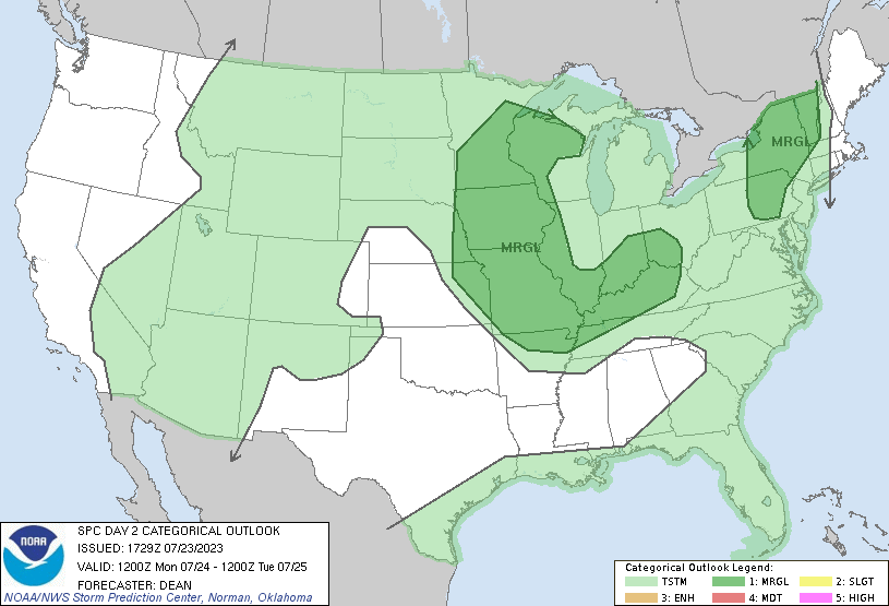
Marginal risk means that an isolated severe thunderstorm is possible.
You can hear updated weather information for Minnesota and western Wisconsin on the MPR News network. You can check MPR’s display of NWS radar here.
You can also check these National Weather Service sites for updated weather info: Twin Cities, Duluth, La Crosse, Wis., Sioux Falls, S.D., and Grand Forks, N.D.
The heat is coming
The Sunday afternoon high temperature at Minneapolis-St. Paul International Airport was 88 degrees. That’s four degrees warmer than the average Twin Cities high temp on July 23. Metro area highs will be around 90 degrees on Monday, with a few spots in the metro area reaching the lower 90s.
Much of Minnesota and west-central Wisconsin will see Monday afternoon highs in the upper 80s to around 90:

There will be some upper 70s in northeastern Minnesota.
Tuesday highs will be even warmer:

On Wednesday, we’ll see highs in the upper 90s in several locations, including the Twin Cities metro area:

Twin Cities metro area highs are also projected to reach the upper 90s on Thursday, then back off to the lower and middle 90s on Friday.
Phoenix hot streak
Sunday was the 24th consecutive day with a high temperature of 110 degrees or warmer in Phoenix, Arizona. The Phoenix high temp hit 119 degrees on two days and 118 degrees on three days during this current hot stretch.
Programming note
You can hear my live weather updates on MPR News at 7:35 a.m., 9:35 a.m. and 4:39 p.m. each Saturday and Sunday.

